
Now in our 34nd year, Integrasys has continued to go from strength to strength, and this year was no exception.
We launched four new innovative products: LEO NMS (Multi-orbit Network Management System), BestPath (Multi-orbit path selector), Orbisat (Space Domain Awareness) and EO Master (Geospatial Intelligence). Each of these products fills a niche in the marketplace and were develped after listening to the unmet needs that were voiced by potential and current customers.
Focus on technical
excellence and
collaboration
Integrasys is a frontrunner in the development of software and engineering tools for the space industry; including satellite network design, deployment, maintenance, monitoring, and securing. We prioritize innovation and
R&D in order to develop advanced tools for interference management, cybersecurity and management of space operations for both the commercial and defense sectors.
We count telcos, satellite service providers, satellite operators and governments around the world among our customers. While some of our products are specific to defense, many of the issues encountered and tools needed when operating a satellite network apply equally to both sectors.
We have a strong portfolio of both commercial and government customers and pride ourselves on the interoperability of our products, not only with each other, but also, in many cases, with other companies’ products, using integrated Restful APIs. We strive to make using all our products intuitive, so they can be used by inexperienced and experienced operators alike.
We’re also very aware that, while we employ some of the top software engineers in the world, we’re stronger together and collaborating and forming alliances with other organizations is to everyone’s advantage.
This year we‘ve worked with Artel to develop LEO NMS, Terran Orbital to further develop our Link Budget tools for multi-payload, multi-orbit applications, with Arabsat for further integration of our APIs within their NMS, and Thaicom, enhancing antenna pointing systems for their networks.
We’ve also strengthened our relationship with Hughes in North America and across the globe, and we’re also working with Network Innovations USG, to provide advanced multi-orbit monitoring systems and interference detection solutions as a global service, to name just a few.
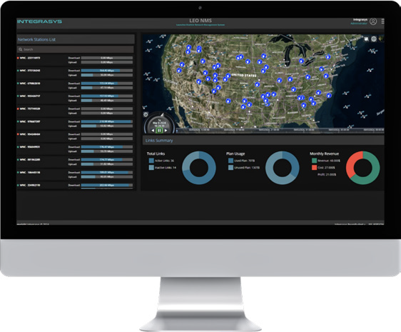
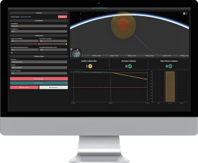
Integrasys' LEO NMS
Of particular importance to us is our continued support for the Ukraine, — although not specifically relevant to the commercial sector, we have developed and improved electronic warfare (EW) products to support operations in that nation.
Our four new products address issues faced by both the commercial and government operators.
LEO NMS
Satellite networks today are very different to those of only a couple years ago. The success of Starlink has completely changed the industry. OneWeb is another that is operating a smaller LEO constellation. Within the next few years, those two will be joined by Kuiper (another huge constellation) and the recently funded Telesat Lightspeed, and perhaps others, as well.
As a result, in many cases a network will consist of bandwidth (Mbits) coming from thousands of satellites operating in multiple orbits, operated by different owners and using different frequencies. A far cry from the networks of only three years ago, when a typical network may have consisted of bandwidth from
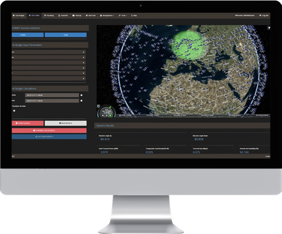
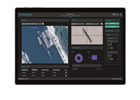
Integrasys' BestPath
few geostationary (GEO) satellites and possibly some from O3b, the sole commercial Medium Earth Orbit (MEO) constellation. We developed a LEO network management system (NMS) after listening to customers complain about the difficulty of managing a network that included numerous Starlink satellites among their traditional network infrastructure. Although Starlink was the “inspiration,” LEO NMS is provider and orbit agnostic; it can handle multi-orbit, multi-vendor and multi-frequency systems in one, combined, network orchestrator.
LEO NMS gives users full control of the network and allows them to see the performance of everything from a single terminal to an individual customer’s network, to the complete network of thousands of terminals for the numerous customers under their control, on a single web-based intuitive screen. It facilitates orchestration, management and maintenance of multiple networks of multi-orbit, multi-frequency, multi-provider satellites, in a seamless and integrated manner.
LEO NMS includes numerous tools to automate and optimize network management up/down speeds, Quality of Service (QoS), and Service Level Agreements (SLAs), for example. Financial reports, contracts and invoices can also be generated. All of this can be accessed via a fully redundant, public or private cloud. It seamlessly integrates with BestPath and other Integrasys products within the Enterprise Management and Control portal.
There is also a customer portal effectively creating a VNO, so that an operator or service provider can offer its customers the filtered ability to see and securely monitor their own networks.
In today’s multi-orbit, multi-frequency, multi-vendor networks, LEO NMS is an essential tool.
BestPath
With the exponential growth in numbers of satellites, created by the LEO constellations, and the rapid increase in multi-orbit offerings, selecting the best connectivity path had become an onerous task, which is why we created BestPath, a disruptive technology based on our Enterprise Management and Control system for ensuring reliable connectivity.
Integrasys' Orbisat
BestPath allows a user or a system to effortlessly compare many different link budgets, options and scenarios to buy or connect to. It is the key to simplifying and automating network selection, purchasing, design and orchestration. It also provides program execution, once a path has been chosen. The best connectivity
path can be selected in less than one second considering user specified criteria, in conjunction with real-time feedback. Links are optimized for each individual customer and for multiple different scenarios with maximum flexibility to cover any use case. Automatically generated reports include well documented reasons behind path selection.
BestPath is an invaluable tool when it comes to selecting a primary and backup link, whether the latter is needed because of service disruption to due to adverse events, electro-magnetic interference (EMI), power outages, cyber events etc., or due to a ship/plane/vehicle maneuver or a military vehicle being required to switch to electronic warfare (EW) systems.
BestPath can integrate with FlexCap capacity management for resource orchestration, and using APIs seamlessly integrate into other systems and automatically orchestrate the BW required for the change. It is a web-based tool that can be accessed from anywhere.
Orbisat
LEO constellations don’t just bring more bandwidth and connectivity options, they also bring more congestion, much more congestion.
Integrasys' EO Master
Space is now more crowded than it ever has been before, and this congestion increases almost daily as more satellites are launched. In addition, mission failures or other accidental incidents, create debris, adding to the congestion, Orbisat is API-driven allowing easy integration with radars, telescopes, optic sensors and classified systems as well as onboard GPS for better and more accurate surveillance. Whilst the impetus for Orbisat came from US Spaceforce, congestion and debris is an equal problem for commercial operators.
Orbisat integrates with existing proprietary and public subsystems allowing seamless tracking, collision avoidance, telemetry, maneuverability detection, Telecommand & Control as well as discovering undocumented objects in all orbits, and deep space. It not only is interconnected with two public databases, Celestrack and Spacetrack, it is also constantly updated with information from integrated antennas, monitoring and measuring S-Band links in orbit, and at launch and early orbit phase (LEOP).
Our under the noise floor level, monitoring capabilities, ensures that unidentified, unrecorded objects will be found. Orbisat does not just identify objects, in case of a potential collision it integrates with TT&C to enable automatic maneuvers to avoid the threat. It also analyzes foreign object behavior to identify potential threats.
Orbisat goes one step further than existing SSA/SST systems.
It provides a system of systems to automate the protection of our space infrastructure. It can be deployed at all security levels in the cloud or on premises. It is hard to overestimate just how important Orbisat is. A major collision at any orbit is likely to have a huge impact in the domain.
EO Master
In the extremely time-sensitive world of geospatial intelligence (GEOINT), timely identification of objects is crucial. EO Master integrates artificial intelligence (AI) and machine learning (ML) into image processing to enable image characterization within milliseconds of an image being downloaded.
EO Master is integrated with AI/ML libraries and algorithms for vast real-time analysis. The image is compared with millions of 3D models on file (For defense applications images of the latest global military platforms can be included for comparison). A restful API is used for easy integration to machine-to-machine automated systems to facilitate fast decision making.
Currently, Earth Observation is provided by both optical and synthetic radar (SAR) systems, with varying degrees of accuracy, and the tools to use each of these are proprietary, EO Master is the first system to utilize both options for object characterization.
The user interface is an easy-to-use, graphical user interface (GUI), allowing governments and other users without deep technical knowledge, to identify the immediate impact of natural disasters, identify traffic and population patterns, and for defense applications compare real versus fake objects.
Geospatial intelligence has many uses. It is a powerful tool for environmental monitoring For disaster response and recovery, it has become a necessity, indicating to first responders where the worst hit areas are, and where access is possible. It is becoming a vital tool for fighting forest fires, and also for identifying cracks in dam walls that may indicate imminent breaches, to mention just a few applications.
For the military, GEOINT is literally “the eyes in the sky,” indicating troop buildup and movement, as well as identifying armaments on the ground.
Our Success
This has been a great year for the company. We attribute much of our success to close communication with our customers. When they buy a product they also gain a trusted relationship they can count on.. We’re there if they need help.
We listen to their needs, in order to develop products to fulfil their latest requirements. How successful this has been is evidenced not only by the longevity of our customers, but by the number of technology awards that we have won, including a Satellite Innovation of the Year award from MSUA for the last three years.
We’re looking forward to 2025 and will continue to stay close to our customers, to listen to their needs, and help them grow and improve their bottom line.
About the author
Álvaro Sánchez, Marquis of Antella, CEO at Integrasys is a Software and Industrial Engineer, with a Master’s Degree in Business from ESIC Business School (Spain). He has worked at Integrasys since 2011, initially in engineering, then management and sales executive roles where he was very successful in growing both revenue and profit, before becoming CEO in 2018. Prior to joining Integrasys he worked at CERN, the European Organization for Nuclear Research as an RF Engineer with responsibility for measuring the timing for a Nanosecond Synchronization, used for measuring the Neutrino Speed. In 2021 Sánchez took on the role of Professor, teaching “Introduction to Business Management” for the AI degree at the IE University (Madrid), thus achieving his goal of helping others. In 2021 he was named by SSPI and one of the 20 under 35 Space Professionals. His current focus is on growing Integrasys; developing new products, forging alliances with other defense and commercial organizations if appropriate, as well as partnering with MoDs and DoDs. In addition, he is also focused on geographical expansion with the opening of two new offices, one in London and one in Ukraine, in the last 18 months.