Using space to keep whales safe
Satellite data can be used in a wide range of fields, including climate change studies, maritime surveillance and the protection of ecosystems and biodiversity. Now, suppose the data were used to help keep whales safe.
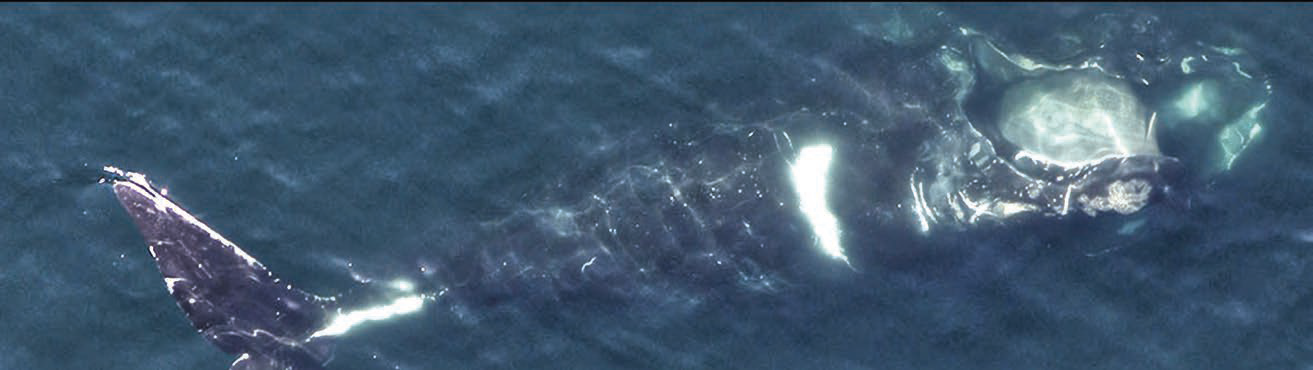
Aerial photo of a North Atlantic right whale named Ruffian. (Credit: Centre for Coastal Studies NOAA federal permit #19315-01) 
This is what the Canadian Space Agency, in co-operation with Fisheries and Oceans Canada and Transport Canada, has called for with the launch of the smartWhales initiative. As a result of a request for proposals published in June of 2020, five Canadian companies were awarded contracts under the smartWhales initiative to advance solutions, using satellite data, to protect North Atlantic right whales (NARWs) in Canadian waters.

This species is designated endangered and occurs along the North American coast of the Atlantic Ocean, where substantial fishing and commercial shipping activities take place. These conditions pose risks for NARWs, including vessel collisions and entanglement in fishing nets.
The projects carried out under the smartWhales initiative focus on two streams: detection and monitoring of the NARW, and prediction and modelling of NARW behaviour and movement in their habitat. Discover the innovative approaches implemented by the five companies and their partners to gain a better understanding of the species’ life habits and help reduce the risks they face as a result of human activity in these environments.
Satellite imagery to
better understand
NARW habitat

Arctus has rolled out the Système intégré de modélisation de la baleine noire de l’Atlantique Nord [Integrated modelling system for the North Atlantic right whale] (SIMBA) project. The company and its collaborators use satellite images to learn more about the whales’ locations. Combining these images with habitat prediction models enables a better understanding of NARW behavior and movement. This information will be valuable to authorities and fishers, who can use it to guide decisions on how best to co-exist with NARWs.
As part of the SIMBA project, Arctus is creating maps of areas where the zooplankton that whales feed on can be found. By combining these maps with satellite images, experts are able to determine where whales are most likely located and gather key information about their marine habitat. Satellite images enhance whale habitat prediction models by providing insight into ocean conditions. They show variations in water colour, caused mainly by the presence of phytoplankton, a tiny plant organism on which zooplankton feed.
Operational object-
detection models
for detecting and
monitoring North
Atlantic right whales
with OCIANA™

Global Spatial Technology Solutions’ (GSTS) proprietary platform, OCIANA™, has been recognized by the maritime transportation industry for delivering solutions to enhance decision making across the maritime supply chain and logistics. As part of the smartWhales initiative, GSTS has created a novel whale detection and monitoring system
to aid in the understanding of environmental impacts, and more importantly, to facilitate how vessel operators and ports can take action within the scope of their day-to-day activities to protect marine wildlife.
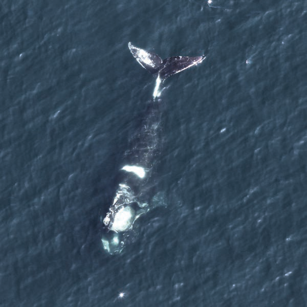
Photo credit: Aerial photo of North Atlantic Right Whale,
Catalog #4714, NARWC, 2019.
Data sources from a variety of satellite providers can be used to screen and detect whales if they exist at or just below the ocean surface. Intelligent tasking based on habitat quality models and vessel traffic can optimize acquisition of appropriate satellite imagery.
That imagery is automatically ingested into OCIANA™ and processed into a form suitable for object detection models. Through the integration of several key data sources with artificial intelligence-based models and OCIANA™, GSTS’s maritime artificial intelligence platform, vessel operators and other stakeholders can take action to mitigate risks to the North Atlantic right whale (NARW).
Several additional capabilities were developed, including the implementation of a dynamic whale risk model which incorporated environmental data on predicted location and abundance of its primary food source (copepods of the genus Calanus, a species of zooplankton).
Hatfield and its partners have created a system that uses artificial intelligence to find potential whales in satellite images, automatically and quickly. This space-based detection system (SBDS) shows only the parts of large satellite images where it found possible whales, reducing the area that needs to be checked by 98%. In a 2023 test over a large area of 2,000 km2, Hatfield’s SBDS found 75% of the whales in the satellite images. More importantly, it was able to do so in only a few hours, compared to the many days needed for a human without the system.
The SBDS saves the locations of the whales and displays them on an interactive map. It can also find whales in a variety of water conditions and world locations and even found the first likely NARW in the Gulf of St. Lawrence ever seen in a satellite image.

A predictive modelling system for the enhanced protection of the NARW in the Gulf of St. Lawrence. WSP Canada, DHI Water & Environment Inc. and their partners
developed a Web-based decision support system (DSS) allowing to forecast suitable whales’ habitats and predict their movements in the Gulf of St. Lawrence up to 3 days into the future. The DSS has the capability to combine a 12-hour forecast of commercial vessel traffic and snow crab fishing area delineations, allowing – as a first – to predict and prevent potential whale-vessel collision and fishing gear entanglement risks.
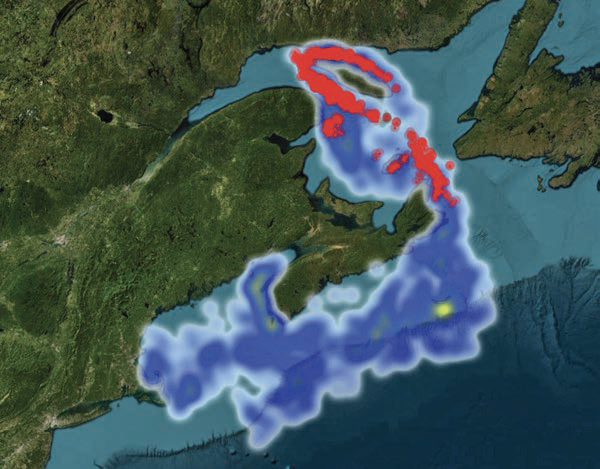
NARW presence
and the risk of
collisions
This map of the Gulf of St. Lawrence and Maritimes regions illustrates the likelihood of NARW presence and the risk of vessel collisions. It combines vessel trajectory data (automatic identification system for vessels), satellite data on environmental variables and whale sightings from aircraft or reported by volunteers. Legend: red = risk of collision between vessels and NARWs, yellow = high risk of finding NARWs, blue = potential risk of finding NARWs. (Credit: ESRI World Imagery)
The DSS Web-based tool is based on academic and commercial models, including hydrodynamic and ecological characteristics such as ocean currents, temperature and nutrient load in the ocean along with
accurate vessel trajectories. The WSP group’s DSS models could potentially be integrated into future forecasts, and help drive forward future advancements in the field of conservation science.
For detections that occurred, GSTS used vessel path prediction tools to look for potential collision risks. Such data could help provide unprecedented intelligence to seafarers and navigators operating in the NARW habitat. This data is used by OCIANA™ to provide dynamic route and speed data to be recommended to vessels, enabling optimized time of berth arrival while protecting endangered marine species.
Fluvial Systems
Research (FSR)
Satellite observation of North Atlantic right whales and RADARSAT Constellation Mission (RCM) detection of their feeding areas.
FSR developed the Satellite Acquisition and Right Whale Detection Algorithm (SARDA) using detection algorithms over optical and synthetic aperture radar (SAR) satellite imagery to detect and identify the NARW and its potential feeding areas. In these areas, there is an accumulation of organic materials, such as zooplankton (the prey of NARW), which makes them suitable feeding grounds for these whales.
Optical imagery involves the use of sunlight, much like photography, to capture objects that are visible, while SAR imagery, particularly from the RCM, is mostly used to provide information about the surface roughness of Earth and the ocean.
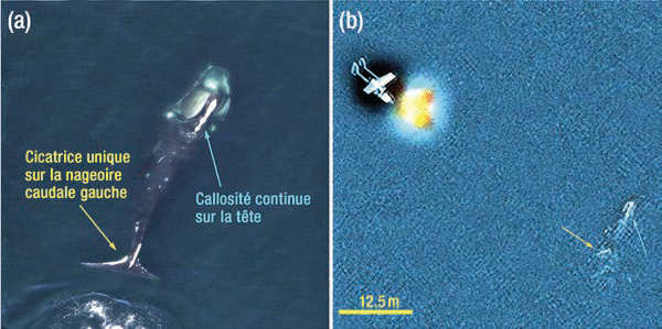
FSR performed the first demonstration that optical satellite imagery can be used to detect and confirm the NARW at a species level and identify a specific individual. As an example, on the image below, a biologist on board a vessel acquired a photograph of a whale named Halo. At the exact same time, the FSR team captured a 30 cm WorldView-3 satellite image of the aircraft and the whale. The white scars along the leading edge of Halo’s left fluke and her continuous head callosity could be seen in both images.
FSR also demonstrated that NARW feeding areas may be characterized by the presence of oily slicks of biological origin. These slicks form a thin film sufficient to suppress the roughness of the ocean’s surface. They can also be seen as dark filaments in SAR images. A correlation was established among the SAR image detection and recorded locations of the research vessel in Cape Cod Bay and in the Gulf of St. Lawrence, along with drone visible imaging observations over the RCM acquisition areas.
Finding whales in satellite
imagery automatically
and quickly using artificial
intelligence (AI).
Finding endangered whales like the NARW in large areas like the Gulf of St. Lawrence helps protect them from fishing lines and ships. However, monitoring these large areas regularly can be challenging. Satellites take detailed images of large areas, but it can take days or weeks to look over them to find any visible whales.
Hatfield and its partners have created a system that uses artificial intelligence to find potential whales in satellite images, automatically and quickly. This space-based detection system (SBDS) shows only the parts of large satellite images where it found possible whales, reducing the area that needs to be checked by 98%. In a 2023 test over a large area of 2,000 km2, Hatfield’s SBDS found 75% of the whales in the satellite images. More importantly, it was able to do so in only a few hours, compared to the many days needed for a human without the system.
The SBDS saves the locations of the whales and displays them on an interactive map. It can also find whales in a variety of water conditions and world locations and even found the first likely NARW in the Gulf of St. Lawrence ever seen in a satellite image.
A predictive modelling system for the enhanced protection of the NARW in the Gulf of St. Lawrence.
WSP Canada, DHI Water & Environment Inc. and their partners developed a Web-based decision support system (DSS) allowing to forecast suitable whales’ habitats and predict their movements in the Gulf of St. Lawrence up to 3 days into the future. The DSS has the capability to combine a 12-hour forecast of commercial vessel traffic and snow crab fishing area delineations, allowing – as a first – to predict and prevent potential whale-vessel collision and fishing gear entanglement risks.
NARW presence
and the risk of
collisions
This map of the Gulf of St. Lawrence and Maritmes regions illustrates the likelihood of NARW presence and the risk of vessel collisions. It combines vessel trajectory data (automatic identification system for vessels), satellite data on environmental variables and whale sightings from aircraft or reported by volunteers. Legend: red = risk of collision between vessels and NARWs, yellow = high risk of finding NARWs, blue = potential risk of finding NARWs. (Credit: ESRI World Imagery)
The DSS Web-based tool is based on academic and commercial models, including hydrodynamic and ecological characteristics such as ocean currents, temperature and nutrient load in the ocean along with accurate vessel trajectories. The WSP group’s DSS models could potentially be integrated into future forecasts, and help drive forward future advancements in the field of conservation science.