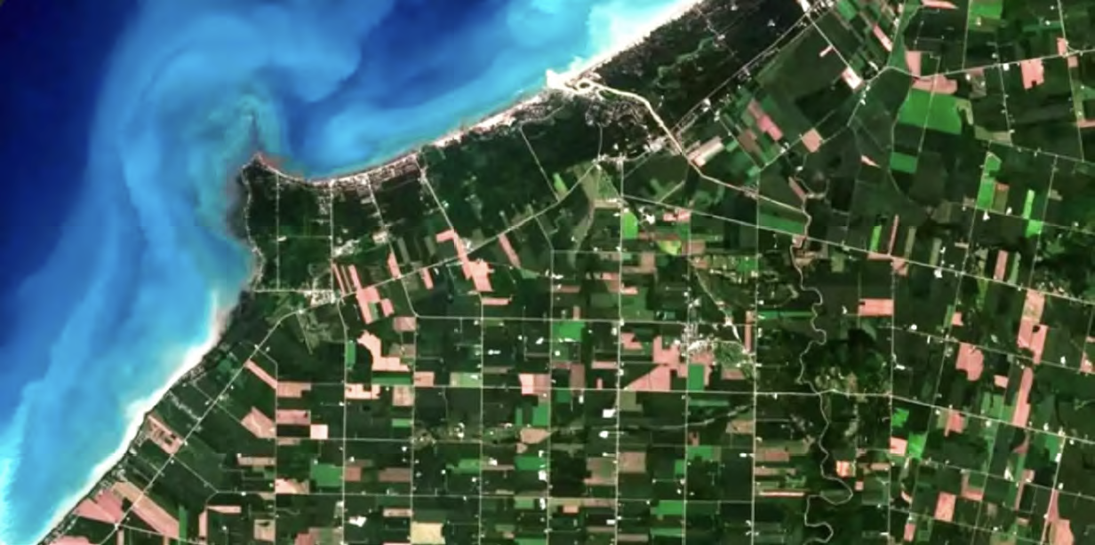
In the 21st century, remote sensing has become a game-changer for tackling environmental issues — satellites, drones, and aircraft offer scientists crucial data about the Earth without the need for direct contact with the object of observation. This acquired information is essential for monitoring deforestation, tracking climate change, predicting natural disasters, and managing urban development sustainably.

One of the standout benefits of remote sensing is the technology’s ability to cover vast, hard-to-reach areas, providing real-time insights that aid in disaster response and environmental conservation.
With many free satellite imagery providers now available, this technology is more accessible than ever, empowering researchers and policymakers around the globe to better study and protect our ecosystems.
Protected Areas
Monitoring
Protected regions, whether nature reserves, wildlife sanctuaries, or national parks, require constant surveillance to maintain their ecological integrity. Through satellite imagery and advanced technologies, remote sensing allows scientists to observe and analyze these areas without disturbing their delicate natural state. It provides real-time data on land cover changes, deforestation, and the health of various habitats, which is crucial for detecting illegal activities such as poaching and logging, assessing the impact of climate change, and managing conservation efforts effectively.
The ability to monitor protected areas from a regional to global scale is one of the most significant advantages of remote sensing. It enables continuous tracking of biodiversity, wildlife movements, and ecosystem dynamics, offering insights that are necessary for smarter management, especially of areas that require special attention.
Water Resource
Management
Although water covers more than 70% of the Earth’s surface, usable water resources are tenuously stretched. Managing this issue requires vigilant observation and precise analysis with the help of free satellite imagery. Remote sensing allows for capturing comprehensive data on water bodies, along with measuring critical parameters like temperature, turbidity, and chemical composition.
One of the significant benefits of remote sensing is its ability to monitor water quality, detect pollution sources, and map wetlands.
For instance, remote sensing can identify harmful algal blooms in lakes or trace pollutants in rivers, enabling timely interventions to protect aquatic ecosystems and ensure safe drinking water supplies. Moreover, it allows authorities to track changes over time, identifying areas at risk of contamination or depletion, and guiding effective management strategies.
In essence, remote sensing acts as the guardian of our water resources. It helps preserve these vital assets while supporting sustainable industrial practices. By balancing environmental protection with industrial needs, remote sensing ensures the long-term health and availability of our planet’s most essential resource.
Agricultural
Monitoring
Agriculture is one of the biggest consumers of free, high resolution, satellite imagery. That is due to a huge set of undeniable benefits this tool has to offer for this industry. To monitor significant fluctuations in vegetation and understand their environmental impact, scientists can employ satellite remote sensors to measure and map the density of green vegetation globally. These sensors capture the wavelengths and intensity of visible and near-infrared light reflected by the land cover, which are then processed using advanced algorithms and vegetation indices.

This data quantifies green leaf vegetation concentrations, monitoring crop vitality, biomass, chlorophyll content, photosynthetic activity, and canopy structural variations.
• Vegetation indices derived from remote sensing have a wide range of applications in farming, including:
• Tracking how vegetation responds to changing climate conditions helps in understanding long-term environmental impacts
• Estimating soil moisture levels, crucial for effective irrigation planning
• Identifying early signs of drought for timely interventions to mitigate crop loss
• Optimizing irrigation schedules and overall crop management practices
• Understanding water usage and loss through evaporation and transpiration for smarter water management
• Assessing changes in biodiversity
• Classifying vegetation types to support better land use planning
By providing detailed and accurate insights into crop conditions, analyzed satellite data empowers growers to make informed decisions, ultimately enhancing crop yields, sustainability, and resilience against environmental challenges.
Forest Health
Assessment
By capturing detailed imagery from satellites and aircraft, remote sensors help analyze canopy density, forest structure, and more. This data allows researchers and forest managers to monitor changes and detect early signs of diseases, pests, and environmental stressors that threaten forest stands.
This means the signs of trouble can be identified early, enabling timely and proactive measures to mitigate potential threats.
Whether it’s pinpointing areas affected by invasive species, detecting early stages of tree disease, tracking illegal logging, monitoring wildfires, or assessing the impact of drought, remote sensing provides critical insights needed to preserve and protect forest ecosystems.
Air Quality
Assessment
Industrial zones, with their factories, mines, and heavy transportation, are notorious for high levels of air pollution.
These pollutants, including particulate matter, nitrogen dioxide, and ozone, pose serious health risks like respiratory diseases, cancer, and asthma, while also contributing to environmental issues such as acid rain and climate change.
Using satellites and specialized sensors, remote sensing collects comprehensive data on these airborne pollutants. This allows scientists and governments to monitor pollution levels, trace sources of contamination, and evaluate the effectiveness of air quality management strategies.
Real-time data analysis enables prompt action to mitigate pollution and protect public health from the adverse effects of poor air quality.
In addition, remote sensing provides a detailed understanding of the spatial and geographical distribution of pollutants, which is crucial for implementing targeted responses in regions most affected by it.
Coastal Zone
Management
Coastal zones are vibrant and sensitive environments that demand meticulous management and monitoring.
Remote sensing technology offers a powerful tool for this task, capturing detailed data on shoreline changes, erosion rates, and sediment transport. By using satellites and specialized sensors, remote sensing provides a comprehensive and dynamic view of these ever-changing landscapes.
This invaluable data aids in effective coastal zone planning and helps assess the vulnerability of coastal communities to sea-level rise. It also plays a crucial role in preserving valuable ecosystems like coral reefs and wetlands, which are essential for biodiversity and coastal protection.
Climate Change
Analysis
Understanding the impact of climate change is vital for creating effective mitigation and adaptation strategies.
Remote sensing offers a window into our planet’s changing climate by providing valuable data on key variables such as temperature, precipitation, and vegetation dynamics.

Remote sensing enables professionals to capture climate indicators data with remarkable precision, often applying the most recent free satellite images to ensure up-to-date analysis.
By continuously monitoring these variables over time, scientists can analyze trends, model future climate scenarios, and assess the impacts on ecosystems and vulnerable regions.
This data helps identify areas at risk, track the progression of climate change, and evaluate the effectiveness of current policies.
EOSDA LandViewer
Free Access To Satellite Images
EOSDA LandViewer is a GIS database with an easy-to-master interface that gives free access to the most widely used open-data satellite maps, offers free previews of high- resolution satellite imagery, allowing you to select and order only the ones you require, and features extensive analytic tools.
EOSDA LandViewer offers medium and high res satellite imagery online free
Imagery: EOSDA LandViewer offers miscellaneous global satellite imagery. You can get the most recent free satellite images from Landsat 7, Landsat 8, Sentinel-1, Sentinel-2, CBERS-4, MODIS, aerial data from NAIP, or historical satellite imagery from Landsat 4 and Landsat 5. On the platform, you may also search and preview for free high-resolution commercial satellite imagery from the world’s top providers before deciding which exact pieces to purchase. Some of the datasets from high-resolution satellite imagery providers you can find there include Kompsat-2, Kompsat-3, Kompsat- 3A, SuperView-1, SuperView-2, SuperView-3, SuperView-4, Gaofen-1, Gaofen-2, Ziyuan-3, GEOSAT-2, and TripleSat; the best spatial resolution comes up to 40 cm per pixel.

Search: The search for free satellite topographic maps is simple and straightforward: once you set the Area of Interest using one of the multiple options (including file upload), select the type of sensor, and pick the dates. Additionally, you are free to apply cloud cover percentage, solar elevation, and AOI coverage percentage filters. Make sure to save your Area of Interest and subscribe to new scenes to get notifications about the newest satellite images, free of charge, available for your chosen territory.
Download: When it comes to downloading free satellite maps, EOSDA LandViewer has a lot to offer. Let’s imagine you’ve come for a free Sentinel satellite imagery. What are your options? First, you can download a free full or manually cropped Natural Color Sentinel image in JPEG, KMZ, or GeoTIFF. If you need only specific spectral bands, use the Analytic download tab to get only those you will use. The third option is downloading a processed image: a band combination or a calculated index. If you don’t want to store satellite maps on your PC, use the WMS feature to streamline it for desktop GIS software.
Analysis: Unlike most free satellite imagery providers, EOSDA LandViewer enables instant visualization and analysis of the maps you’ve found. More than 20 default band combinations and indices such as NDVI, NBR, and SAVI, the raster calculator-like custom index builder, time series analysis, clustering, change detection, and more of its tools are meant to help extract value from online satellite maps for free.
EOSDA LandViewer is the best free real-time satellite imagery provider for GIS beginners and experts from other industries (agriculture, forestry, construction, mining, communications, environmental protection) who don’t use special GIS software and are looking for updated satellite maps with fast and accurate analytics included.
Search for AOI-specific satellite imagery, apply custom band combinations and download for free.


