
Two Industry Experts Added to SpaceLink's Management Team
SpaceLink, a company that is building an information superhighway for the space economy, welcomed two industry experts to the firm’s management team.
Robert Conrad has joined the company as Vice President of NASA and Civil Space business development, and Phil Robinson is Vice President and Chief Security Officer. They join a group of business and technology professionals who have demonstrated confidence in the prospects for a relay service that provides secure, continuous, high-capacity communications between Low Earth Orbit (LEO) spacecraft and the ground.

Robert Conrad has supported dozens of satellite missions with NASA, NOAA, the NSF and JPL. He has deep domain knowledge of TDRSS and experience working with the NASA Space Communications Network and Satellite Ground Network. He spent 17 years at LJT & Associates, a small business government contractor that provided a range of aerospace services, where he was President and CEO.
Mr. Conrad earned a Master of Science degree in Electrical Engineering from Johns Hopkins University where he concentrated on RF and Satellite Communications and he has a Bachelor of Science degree in Electrical Engineering.

As Vice President and Chief Security Officer, Phil Robinson is responsible for SpaceLink’s tactical and strategic security operations. A retired U.S. Army Special Forces veteran, his more than 30-year career encompasses protection of sensitive technologies and classified information, human and counterintelligence operations, and information systems. He has been recognized by the DoD for administering exceptional security, risk, and technology protection programs and he holds a graduate degree in Security Management from Webster University.
A senior member of several well-regarded professional security organizations, Mr. Robinson has served as an industry representative on the National Industrial Security Program Policy Advisory Committee.

He is often an invited guest of the Director for OUSD(I) Security and Intelligence and Director of the Defense Counterintelligence and Security Agency to advise on critical national security issues.
The demand for fast, continuous, high-capacity connectivity for spacecraft on-orbit already outstrips supply and with LEO spacecraft proliferating, it is only destined to grow. SpaceLink will relieve the bandwidth bottleneck for organizations that need to transport data quickly and securely to users anywhere in LEO orbit or on Earth.
The SpaceLink relay network is designed to pick up where the U.S. Tracking and Data Relay Satellite System (TDRSS) leaves off and go beyond with unprecedented capacity that leverages today’s technology advances.
It helps close the business case for Earth Observation (EO) companies, commercial space stations, satellite servicers and tugs, and meets requirements for the
U.S. government and close allies that need to leverage industry solutions to maximize capabilities.

“SpaceLink continues to attract the industry’s top professionals who are inspired by our business strategy and the opportunity to contribute to our game changing data relay service,” said David Bettinger, Chief Executive Officer at SpaceLink. “Robert Conrad and Phil Robinson each bring skills and experience that will be essential to SpaceLink’s success and I couldn’t be more pleased to welcome them to the team.
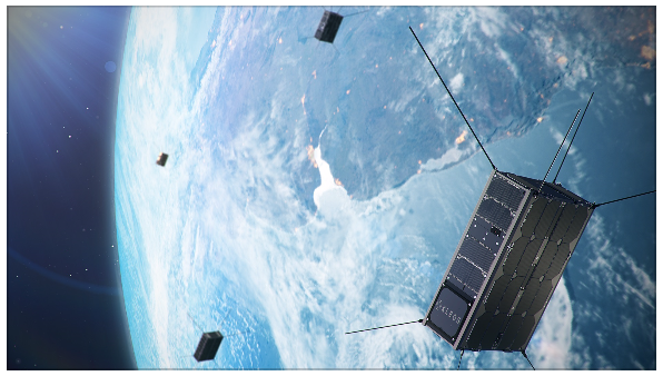
Kleos Space Engages ISISPACE To Build The Company’s Third Satellite Cluster
Kleos Space S.A (ASX: KSS, Frankfurt: KS1, Kleos or Company), a space-powered Radio Frequency Reconnaissance Data-as-a-Service (DaaS) company, has signed a contract with Innovative Solutions in Space B.V. (ISISPACE) to build and support the firm’s third satellite cluster of four satellites, the Polar Patrol Mission (KSF2), scheduled to launch at the end of 2021 onboard a SpaceX Falcon 9.
Specializing in smallsat solutions, the Netherlands-based ISISPACE has more than 15 years of experience in the design, manufacture, and operation of smallsats and is currently also preparing Kleos’ second satellite cluster, the Polar Vigilance Mission (KSF1) for dispatch to the launch site week commencing May 31.
Under the contract, ISISPACE will provide a turn key solution including design, development, production, testing, launch integration services and early orbit phase support. The Polar Patrol Mission creates an opportunity for higher value subscriptions, increasing revenues by adding more frequent cover over commercial areas of interest and additional data products to the Kleos inventory.
Kleos will pay the approximate 2.45 million euros contract in milestone-based installments, with satellite delivery scheduled for Q4FY21. The contract includes an optional addendum for a further three satellite clusters (12 further satellites in total) that will facilitate constellation growth with volume purchasing advantages.
Funding methods for subsequent clusters will be determined by the directors and will be through a combination of revenue, equity or borrowings, depending on capital market conditions prevailing at the time.
Launching into a 500-600 km Sun Synchronous Orbit (SSO), Kleos’ third satellite cluster doubles the company’s coverage over both poles, complementing the Scouting Mission and Polar Vigilance Mission satellites, thereby enhancing global coverage. Data derived from the Scouting Mission satellites is expected to commence to early adopter customers shortly.
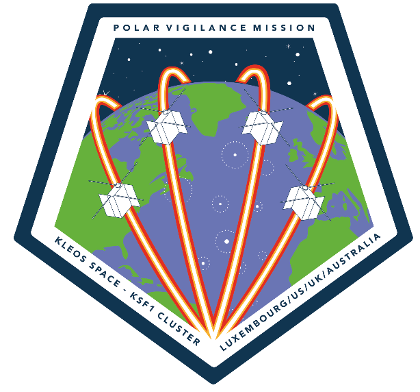
Kleos’ Polar Vigilance satellites are on track for a mid- 2021 launch onboard a SpaceX Falcon 9, following the recent successful completion of key development milestones with ISISPACE. Kleos’ satellites collect data that is used to detect and geolocate radio frequency transmissions, enhancing the detection of illegal activity, including piracy, drug and people smuggling, border security challenges and illegal fishing.
Its global activity-based data is sold as-a-service to governments and commercial entities, complementing existing commercial datasets to improve their intelligence, surveillance,and reconnaissance (ISR) capabilities.
Kleos Space CEO Andy Bowyer said, “ISISPACE has proven to be an ideal development partner for Kleos,with our second satellite cluster nearing completion ahead of a mid-year launch. Targeting a constellation of up to 20 satellite clusters, each new satellite cluster will increase sensing and intelligence gathering capabilities generating higher value data products for subscribers.”
Jeroen Rotteveel, CEO of ISISPACE, said, “We are proud to continue our partnership with Kleos, using our extensive nanosatellite experience to build and design their third satellite cluster within a relatively short timeframe. Asa strategic partner, we look forward to supporting them as they continue to build and launch their small satellite constellation.”
Introducing Ursa Space’s Image Services
As the number of satellites launched into orbit continues to increase, the volume of imagery is growing exponentially, creating a trove of valuable insights waiting to be gleaned from the data. There are many SAR satellite providers responsible for this growth, creating lots of terrific options — how does one select the correct provider?
It would be easier If a significant amount of this imagery were housed under one roof, this selection task would be far easier… this is where Ursa Space enters the picture, with its recently launched Image Services offering.
How can you realize this potential opportunity by accessing the satellite imagery, particularly from synthetic aperture radar (SAR) technology?

Eric Cote, a Product Manager at Ursa Space, recently highlighted the company’s new, image services offerings.
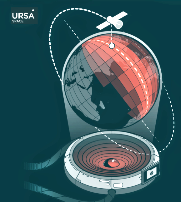
Ursa Space’s Image Services provides a one-stop source for commercial SAR imagery, he said. With this service, customers can search and order imagery from the company’s growing archive catalog of more than 8 million images and 14 years of history. Customers can also use this service to task new images from the firm’s Virtual Constellation, the world’s largest network of SAR satellites from vendor partners.
Ursa Space has partnered with a number of SAR providers, so when someone comes to us, they instantly have access to all of the imagery in each provider’s archives as well as access to task new images from each provider’s satellite network.
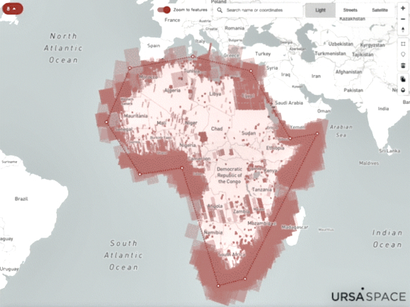 This image shows some of the existing imagery available from Ursa Space’s Virtual Constellation catalog. For this example, parameters included some of the major SAR providers covering Africa during a selected time period.
When someone wants an image for an upcoming date, they tell us the basics—where and when—and Ursa Space handles the rest. More advanced users can also choose to provide detailed collection criteria and we’ll do all the legwork to obtain the images that meet the customer’s requirements from our satellite provider partners.
An additional step between order and delivery is processing. Without going into too much technical detail, let’s just say that there are different formats for SAR imagery. If someone is trying to understand and interpret imagery across multiple vendors or formats, they will run into problems without the proper training. People can work with us instead. We have the in-house SAR processing expertise to turn multiple data formats into one common vendor-independent format, which is then delivered to the customer, ready to be used.
There are any number of motivations behind imagery acquisition. For example, if there’s a natural disaster, say a hurricane in Florida, then an insurance company might want imagery to understand the impact of the storm on infrastructure. Where is there flooding? Or, where did buildings sustain the most damage from high winds?
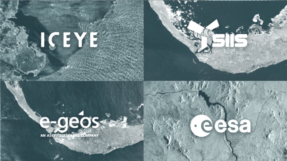
A sample of SAR imagery from some of
Ursa Space’s Virtual Constellation
satellite partners.
Without the proper corrections, a structure or feature might not appear in the same location within each image, leading an individual to conclude that the feature has either changed significantly or disappeared, when in fact, it’s just a technical error because the different formats weren’t properly accounted for in the final product.
Timing is often a crucial factor when a client needs an image. Ursa Space will take care of the processing and deliver the image in one common format. There’s also the benefit of Ursa Space working with multiple SAR providers on your behalf, so you won’t get caught without a backup plan in case of unexpected maintenance or availability issues with a single vendor. We can provide a reliable delivery schedule by tasking a satellite from another provider that’s a part of our Virtual Constellation.

Imagery from Airbus (2019). Processed by Ursa
Space Systems (2021). This is a SAR image of Paris
by Airbus which was then processed into a
“Point of View” perspective by Ursa Space.
The extent of damage can be quickly understood by pulling an archived image to establish a baseline against which the post-event image is compared. This example also makes clear why the benefits of SAR can be critical at times. Unlike optical imagery, SAR works in any weather, day or night. That’s a critical distinction when trying to assess the situation on the ground right after a major storm hits and clouds obstruct the view.
Ursa Space can also assist with image analytics. Using the same example, the company can identify and quantify the damage inflicted by the storm, such as flood mapping or highlighting infrastructure changes.
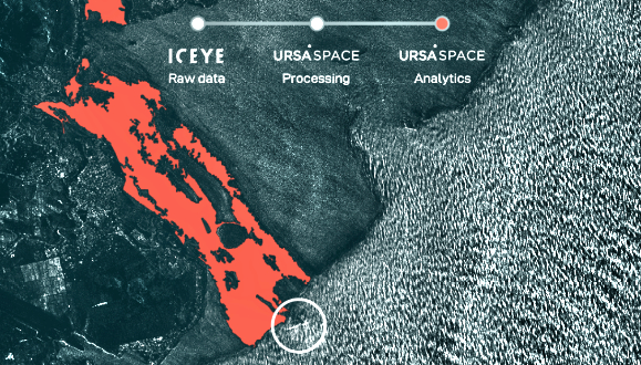
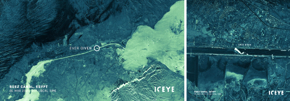
The image above shows the processing and analytics done
by Ursa Space on a SAR image provided by ICEYE, collected
off the coast of Mauritius in August of 2020, after a ship ran
aground, leaking oil into the ocean. The area highlighted in
red is the oil slick.
Another use case is economic monitoring. We can perform analytics to measure economic activity, which is why the archive is so important. Having extensive historical data is critical when trying to interpret current information. That’s true whether it’s a financial firm fine-tuning a trading algorithm, or a local municipality assessing property valuations.
Ursa Space has a streamlined process for searching our catalog, ordering, processing, analyzing, and delivering SAR imagery across a Virtual Constellation from our satellite partners. This provides enhanced capabilities and redundancy when compared to any one vendor alone. Customers can therefore take advantage of the ongoing satellite revolution. As fast as turnaround times are today, they will only improve moving forward.
To learn more about Ursa Space’s Image Services, please access this direct link…
$30 Million Investment To Kymeta From Hanwha Systems
The Committee on Foreign Investment in the United States (CFIUS) has approved a $30 million investment by Hanwha Systems Co., Ltd. (HSC), a global solutions company that provides differentiated smart technologies in defense electronics and information infrastructure to Kymeta Corporation — the communications company making mobile global.
The approval provided by CFIUS clears the way for HSC and Kymeta to close on the transaction that was jointly announced last December. The investment moves Kymeta one step closer toward developing solutions that are future proof and interoperable with both LEO and GEO mega constellations. Today, the Kymeta™ u8 is the only commercially available flat panel antenna that is compatible with LEO and GEO satellite constellations and enabled to take advantage of the growing capacity within space.
The investment from HSC will further Kymeta’s global market reach, accelerate production, and improve the overall growth trajectory of the company. The funding will support increased unit production, enhanced customer experience, and the ongoing development of Kymeta’s next generation capabilities. With the capital investment HSC will also receive a seat on the Kymeta Board of Directors.
HSC plans to support Kymeta’s metamaterial-based antenna technology and gain a foothold in the rapidly growing Low Earth Orbit (LEO) antenna market.
“We are thrilled that the investment is approved and eager to leverage Kymeta’s expertise in hybrid satellite and cellular connectivity solutions,” said Youn Chul Kim, CEO of HSC. “Kymeta’s solutions will further our aerospace capabilities and deliver reliable communications for our defense customers.”
“We look forward to moving ahead and working with HSC,” said Doug Hutcheson, Executive Chairman, Kymeta. “We believe this investment will be instrumental in enabling the continued innovation, advancement and commercialization of Kymeta’s connectivity solutions. We’re excited about the future of Kymeta and the LEO satellite market.”
FCC Filing Completed By Lynk— Global Mobile Connectivity Service Via “Cell Towers In Space” To Be Initiated In 2022
Lynk Global Inc. has filed for a commercial operator’s license with the Federal Communications Commission (FCC). Commercial service is expected to begin around the world starting next year upon FCC approval.

The startup’s patented technology will eventually allow anyone with an existing cell phone to stay connected, anywhere in the world, at all times. Most importantly, Lynk’s system requires no changes to the phone. The existing phone in your pocket will work.
Lynk’s initial commercial license application intentionally uses the FCC’s new streamlined process for up to 10 smallsats to accelerate the license. Previous applications suggest this streamlined process will take

10-12 months, allowing Lynk to start their global service next year. This is the first step in Lynk’s plans for a larger constellation that will grow to several thousand satellites to begin continuous global service in 2025. Ultimately, Lynk’s full constellation will reach 5,000 satellites to provide broadband speeds to your phone.
Using a low-risk development approach, Lynk will integrate some of the most advanced space sustainability methods today to prevent and mitigate orbital debris and is actively advocating within industry and government to develop stronger orbital debris mitigation approaches for tomorrow.
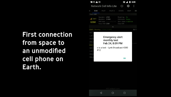
In February 2020, with the help of NASA and mobile network operators (MNO), Lynk sent the world’s first text message from a satellite in orbit to a standard mobile phone on the ground.
Lynk has also signed contracts with the U.S. Air Force and the U.K. Space Agency to support development of the Lynk system.T o date, Lynk has signed dozens of testing agreements with MNOs.
Charles Miller, CEO of Lynk, said, “Lynk is introducing a brand-new, never-been-done-before service—satellite- direct-to-standard-phones. As an American company, we are fortunate to have the FCC, whose process is trusted by officials around the world, to license our satellites. We believe that being good corporate citizens means at every point in the process you must be rigorous—whether it is eliminating harmful interference or minimizing orbital debris. Because using cellular frequencies from space has never been done before, we believe that being licensed by the FCC will help regulators worldwide embrace this groundbreaking technology.”
ICEYE Intros New SAR Satellites
ICEYE recently announced the commercial availability of wide area imaging capabilities covering 10,000 km² data acquisitions with the company’s SAR (synthetic-aperture radar) satellite constellation.

According to the firm, ICEYE is the only New Space SAR satellite provider to achieve wide-area Scan mode imaging, with up to a 100-times larger area coverage from the closest alternatives in the marketplace.
Thanks to the system design of ICEYE’s SAR satellites, ICEYE is now able to provide the world’s single, most comprehensive, persistent monitoring capabilities both for land and sea data use cases.
“It’s really exciting to see another world first from ICEYE. Our leading-edge persistent monitoring capabilities, now boosted with Scan mode, enable our commercial and government customers to quickly and effortlessly survey huge areas for purposes such as sea ice monitoring, ensuring maritime safety and national security use cases,” said Steve Young, Vice President, Business Development and Sales, ICEYE. “Our unique satellite constellation and technology approach makes ICEYE’s capability something alternative approaches simply aren’t able to match.”
“ICEYE’s ability to now generate wide coverage imaging brings an addition to the radar based service market, in particular for maritime users,” said Marte Indregard, Chief Commercial Officer at KSAT, an ICEYE data customer and partner. “As the largest buyer of SAR data for maritime applications we know there is a strong demand for Scan mode images providing effective large area coverage, and we are eager to start delivering this to our customers world-wide.”
These images show the difference between Strip
(medium area), and Spot (detail area) imaging in terms
of their coverage. Each mode has its distinct benefits,
and ICEYE’s unique system versatility allows all data
users to acquire each type for varying information needs.
ICEYE’s new Scan imaging is particularly effective for acquiring wide coverage imagery for maritime use cases, where national security authorities and maritime safety officials require persistent visibility into large sea areas.
The alternative methods of monitoring these areas, such as airplanes and sending out patrol vessels to sea, are costly and not always feasible due to inclement weather or night time. Radar satellite imaging works both day and night, and even through cloud cover. ICEYE provides a current system design that supports comprehensive, wide area imaging.
“We’ve done trials to Scan image areas as large as 100 km x 400 km (60 x 250 miles) with a single acquisition, covering areas at once that would take more than 1500 Spot images as a comparison,” said Pekka Laurila, CSO and Co-founder, ICEYE.
“ICEYE continues to lead the way with several world first technology innovations for the benefit of our customers, as we have continually done since we launched the world’s first New Space SAR satellite over three years ago.”
ICEYE was the world’s first company to launch a SAR satellite under 100 kg in 2018, the first New Space provider to achieve under 1-meter SAR resolution imaging in 2019, the first to demonstrate interferometric capabilities in 2020, and even the first to produce SAR videos from individual satellite passes also in 2020.
In total, ICEYE has raised $15 million in financing, launched 10 SAR missions and has plans to launch as many as 10 more spacecraft during 2021.
Viasat’s IFC System Heading Into 230 Additional Delta Domestic Mainline Aircraft
Viasat Inc. (NASDAQ: VSAT) has announced Delta Air Lines has selected the company’s in- flight connectivity (IFC) solution for an additional 230+ domestic mainline, narrow-body aircraft, expanding the future scale of Delta’s next- generation onboard experience.

Under this expansion, select aircraft from Delta Air Lines’ Airbus 321neo, Airbus 220-300, Boeing 737- 800, Airbus 320ceo and Airbus 319 fleets will be retrofitted with Viasat’s next-generation Ka-band satellite technology. This new aircraft award is in addition to the more than 300 Delta aircraft already announced in January 2021.
With Viasat’s innovative satellite technology — featuring enhanced capacity, quality and speed — Delta customers can stream video or music, browse websites, connect to email, use apps and more—all on their own personal electronic devices.
Additionally, a single Viasat high-capacity Ka-band satellite antenna will power IFC while simultaneously providing live TV access to the seatback screens.
 Delta Airbus 220
“By equipping more than 230 additional aircraft with Viasat IFC, Delta is validating how the system can scale,” said Don Buchman, Viasat vice president and general manager, Commercial Aviation. “We have a proven in-flight connectivity solution that will meet the demands of Delta customers today and the expected increase in demand in the future.”
Select Delta aircraft will be outfitted with Viasat’s latest Ka-band IFC system and will be compatible with Viasat’s complete network of satellites, including Viasat’s first- generation spacecraft and partner satellites, its second- generation spacecraft ViaSat-2, and the forthcoming ViaSat-3 constellation, which is expected to offer global coverage with nearly eight times more capacity than Viasat’s current fleet.According to the company, their IFC solution is an ideal offering to meet both current and future demand, as Delta expects increases for enhanced passenger connectivity and streaming services.
Delta remains focused on delivering innovation in the air and on the ground, having been recognized as one of Fast Company’s Most Innovative Companies worldwide this year, and the airline continues to invest in offering a superior customer experience throughout the travel journey. For more on Delta’s commitment to building the next-generation onboard experience through fast, reliable Viasat Wi-Fi, visit articles and videos on Delta News Hub.