
Landscape monitoring — the ability to precisely detect changes of land features at different scales — is an essential tool that public and private institutions use to assess the conditions of existing infrastructures over time, evaluate sites for the construction of new ones, identify irregularities with respect to urban planning, detect the movement of land and glaciers, prevent and manage natural emergencies, and much more.
While there are several useful field measurement techniques, they are generally expensive and time consuming to implement effectively. On the other hand, space-borne remote sensing enables monitoring and mapping vast areas of territory — including remote areas — providing updated models of temporal and spatial surface dynamics.

Satellite remote sensing has improved dramatically in terms of spatial, spectral, and temporal resolution, with sensors that can detect features down to a 20 cm scale. While the advent of constellations of small remote sensing satellites is enabling applications that require a higher temporal resolution — the ability to repeatedly revisit an area over a given period of time — their spatial resolution is limited to meter-scale maps.

Synthetic-aperture radar (SAR) is a radar sensor that can produce higher resolution two-dimensional images and three-dimensional reconstructions of landscapes by exploiting the motion of the radar antenna over a target region. The term “synthetic-aperture” refers to the fact that the effective size of the antenna is determined by the distance covered by the SAR sensor between when it sends a radar pulse and when it receives it, not by the physical aperture of the antenna itself. This characteristic enables a SAR satellite to produce higher-resolution images with a comparatively small physical antenna.
A space-based synthetic aperture radar (SAR) is the ideal data source for landscape monitoring because it is very precise, it is unaffected by weather or light conditions, and it provides both 2D and 3D maps. The main limits of SAR sensors are the amount of power needed to take a measurement, and the downlink bandwidth. Current state-of-the art sensors are limited to no more than 10-15 minutes of sampling per orbit.
The SAR satellites currently in orbit, owned and operated by governmental agencies, are not available to commercial entities for on-demand services. However, recent technology advancements are enabling a new category of SAR spacecraft that can fill this gap like those investigated by Noctua, a project sponsored by Regione Lombardia, Italy, and developed by a consortium led by D-Orbit S.p.A. that includes Beta 80 S.p.A. Software e Sistemi, Fondazione EUCENTRE, Istituto Universitario di Studi Superiori, RadarSensing/MetaSensing, TRE Altamira s.r.l., with the advice of Fondazione Politecnico di Milano and the support of Lombardia Aerospace Cluster and Fondazione Cluster Tecnologie per le Smart Cities & Communities – Lombardia.
Noctua is a commercial space-based service to collect, process, analyze, and distribute SAR landscape monitoring data. The service features a space segment to collect data, a processing layer to combine and elaborate space-based and ground-based data, and a cloud-based interface that enables end users to query the database and add new requests to the queue.
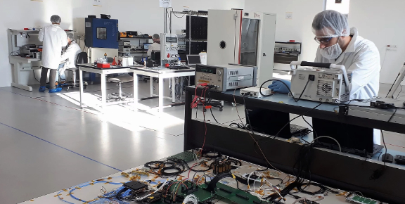
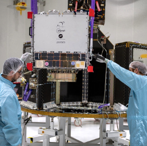
The Noctua space segment is an innovative smallsat developed by D-Orbit, an Italian New Space company equipped with a SAR antenna provided by Metasensing. The satellite is based on D-Orbit’s flagship ION satellite platform, a high-performance spacecraft bus designed with reliability in mind. The sensor is a lightweight, compact, high resolution SAR antenna with a maximum spatial resolution of 30cm, a performance previously unavailable to this class of vehicles.
This combination lowers the barrier of entry to SAR applications, making them accessible to private entities and emerging economies. While the sampling capabilities of a smaller spacecraft like this is limited to 3-4 minutes per orbit, the spatial resolution is not compromised.
A single satellite — much less expensive to build and launch than current platforms — can guarantee adequate coverage of a local municipality.
The ability to operate a fleet of smaller satellites in formation flight ensures the scalability necessary to cover the most demanding scenarios, or to establish commercial end-to-end services available to a much wider range of entities, including private citizens.
A commercial end-to-end higher-resolution SAR service, with the ability to swiftly collect high-precision measurement and allow the user to compare them over time, will enable innovative applications in sectors that require landscape situational awareness like insurance, real estate, precision agriculture, and oil and gas. It will also provide institutional organizations with a complementary data source to integrate with ground sensors and larger, higher performance satellites.
Over time, we can expect this kind of service to become available to a wider audience through computer and mobile apps, opening up new markets and creating more opportunities toward the democratization of space.
www.dorbit.space

Stefano holds a Master’s degree in Space Engineering in a collaboration between the University of Rome "La Sapienza" and the Delft University of Technology. He has worked as Space System engineer in Paris for seven years, focusing on feasibility studies for space exploration and the environmental impact of space activities. When he returned to Italy in 2014, he immediately joined D-Orbit as Program Manager for most of the activities done in collaboration with the European Space Agency. Stefano is now in charge of managing the Institutional Business division, drawing the future of space transportation for the company.