
The Rise Of Anastasia + Adam—Galileos Make Their Way To Orbit
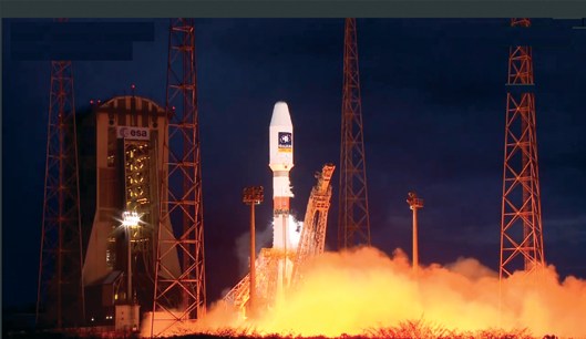
Soyuz Flight VS11 refers to Arianespace’s current Soyuz launch that occurred on March 27 which successfully carried the two Full Operational Capability (FOC) satellites for Europe’s Galileo navigation system to orbit.
Among the many accomplishments of the scientist and astronomer Galileo during his life was the discovery of the four largest satellites of Jupiter (named the Galilean moons in his honor) and now these two satellites, named after him, have been launched.
Soyuz deployed its passengers on a flight that lasted approximately 3 hrs., 47 min. The launcher’s Fregat upper stage, which is responsible for carrying out the final orbital maneuvers, performed two burns that were separated by a three-hour-plus ballistic phase to reach the targeted deployment point for the dual-satellite payload.
Galileo’s FOC phase is being funded and managed by the European Commission, which has designated the European Space Agency as the system’s design and procurement agent. The European Space Agency is delegated as the design and procurement agent on the Commission’s behalf.

The prime contractor for these two Galileo FOC satellites, that weigh some 715 kg. each, is OHB System of Germany. The satellite navigation payloads were supplied by Surrey Satellite Technology Ltd. of the UK. This launch was performed from the purpose-built ELS launch facility for Soyuz.
The Galileo navigation system provides highly accurate global positioning services under civilian control.
Flight VS11 is Arianespace’s second mission performed this year and follows a lightweight Vega launch in February, as well as the 11th Soyuz liftoff performed from French Guiana since this workhorse vehicle’s 2011 introduction at the Spaceport.
According to the European Commission (EC), Galileo will offer greater precision, thanks to a greater number of Galileo signals, the new satellite clock design, and improved corrections of ionospheric effects—positions computed with Galileo satellites will be more accurate.
When combined with GPS, the higher number of satellites available will also offer higher precision. From most locations, six to eight Galileo satellites will be visible, and in combination with GPS signals, this will allow positioning to within a few centimeters, depending on the service used.
Additionally, the high number of satellites will improve the availability of signals in cities where tall buildings can obstruct signals from satellites that are low on the horizon.
Independent studies show, according to the EC infosite, that Galileo will deliver around 90 billion euros to the EU economy over the first 20 years of operations. This includes direct revenues for the space, receivers, and applications industries, and indirect revenues for society such as more effective transport systems, more effective rescue operations, and so on.
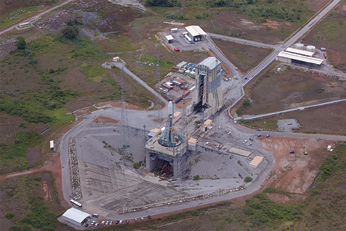
The Arianespace French Guiana Soyuz launch site Photo is courtesy of ESA - S. Corvaja, 2011
The goal of the EU’s satellite navigation programs (Galileo and EGNOS) is to:
• Achieve technological independence with respect to other global navigation satellite systems
• Mobilize the economic and strategic advantages of having European control over the continuous availability of satellite navigation services
• Facilitate the development of new products and services based on satellite signals
• Generate related technological benefits for research, development, and innovation
The European Space Agency (ESA) infosite offers information regarding the Soyuz launch vehicle that was used to deliver these two Galileo satellites to orbit.
The original decision to develop the launch infrastructure to enable Soyuz to be launched from French Guiana was of mutual interest to Europe and Russia, and benefited from funding from the European Community.
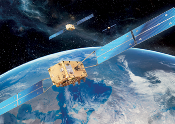
Galileo FOC formation. Image courtesy of OHB Systems.
Soyuz is a medium-class launcher whose performance perfectly complements that of the ESA launchers Ariane and Vega, and increases the competitiveness and flexibility of the exploitation of Ariane launchers in the commercial market.
The Soyuz launch vehicle that is used at Europe’s Spaceport is the Soyuz-2 version called Soyuz-ST. This includes the Fregat upper stage and the ST fairing.
Soyuz-2 is the most recent version of the renowned family of Russian launchers that began the space race more than 50 years ago by launching Sputnik, the first satellite placed in orbit, and then sending the first man into space.
Soyuz-2 has improved performance and is able to carry up to 3 tons into geostationary transfer orbit, compared to the 1.7 tons that can be launched from Baikonur, in Kazakhstan.
Arianespace infosite: www.arianespace.com
The EC infosite: ec.europa.eu/
The ESA infosite: www.esa.int/
Sensing A Fifth Year Of Hyperspectral Imaging Accomplishments For The Naval Research Laboratory
In October of 2014, the fifth-year anniversary for two sensors that the U.S. Naval Research Laboratory (NRL) has been operating aboard the International Space Station (ISS) was celebrated. With the continued and growing interest in hyperspectral imaging from space, a look at the work being done by the NRL is certainly in order.
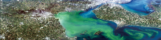
The Hyperspectral Imager for the Coastal Ocean (HICO) took this image of Lake Erie, Ohio on September 3, 2011. Said Dr. Mary Kappus, the U.S. Naval Research Laboratory lead, “Hyperspectral means it takes a picture, but for each spot it separates the light into over 100 separate wavelengths.” Photo is courtesy of the U.S. Naval Research Laboratory.
The Hyperspectral Imager for the Coastal Ocean (HICO) takes images of oceans in many different wavelengths to help scientists see what’s in the water, be it sediment or chlorophyll or runoff.
The Remote Atmospheric and Ionospheric Detection System (RAIDS) also measures light in various wavelengths, but looking at the upper atmosphere and ionosphere.
HICO-RAIDS launched to the ISS as one payload in 2009. Once docked, Dr. Scott Budzien, the Principal Investigator for RAIDS, said, “They took us out and attached us to the ‘porch’ of the Japanese Experiment Module. We have the distinction of being the first U.S. payload that was attached [there].”
HICO and RAIDS were both designed as one-year missions. Said Budzien, “Just about a week ago, we fired up our UV [ultraviolet] instrument again and we’re collecting data as we speak. So, still chugging along—an Energizer Bunny.”
For the first three years, HICO operated with funding from the Office of Naval Research (ONR). NRL partnered with Oregon State University to host a website for the images and to field proposals from outside scientists who want to task HICO to capture certain images.
Today, the National Aeronautics and Space Administration (NASA) sustains HICO. “Now the data also goes to NASA’s ocean color website, where they’ve had open ocean data for years,” said Dr. Mary Kappus, who leads HICO. As of the five-year anniversary, HICO has collected nearly 10,000 images.
Said Kappus, “HICO’s definitely been a really successful transition. It shows the synergy between NASA and NRL and academia. There’s a lot of overlap in the things we need to understand about the ocean. If you work together to do some of these things, you can get a lot of information and share it commonly.”
HICO-RAIDS was integrated and flown under the direction of the Department of Defense Space Test Program. RAIDS was built jointly by NRL and The Aerospace Corporation, with additional support from the Office of Naval Research.
RAIDS accurately measures very fine changes in shades of color from the Earth’s airglow.
“RAIDS is a suite of eight different spectrographs, spectrometers, and photometers,” said Budzien. “We cover a really wide wavelength range—from 50 nanometers in the extreme ultraviolet, all the way out to the near infrared—so we have this unusual, very broad spectral coverage.”
The instrument scans the atmosphere up and down—or, it did. “We scanned from basically the space station altitude all the way to the Earth’s surface, looking down below the horizon.” Then, in December 2010, the scan drive electrically malfunctioned and RAIDS got stuck “pointed down on the atmosphere looking at a slant.” (Electrical malfunctions aren’t unusual for hardware operating in the harsh environment of space.) Even so, Budzien says, “It was a one year mission, and the scan platform worked for 15 months, so we were pleased with that.”
While RAIDS was fully operational, it led to three important scientific discoveries.
First, “We were strongly focused on understanding the temperature of the atmosphere between about 100 kilometers (km) [60 miles] above the surface up to about 150 km [90 miles] above the surface,” says Budzien. “That’s a really difficult altitude range to measure.” By targeting near-infrared wavelengths, Budzien’s team—and partners at The Aerospace Corporation in El Segundo, California—”produced some of the first global measurements of temperature through that altitude range.”
NRL’s breakthrough came from understanding the processes that affect the different energy levels of oxygen molecules as they collide and temperature. “There are many different energy levels in the oxygen molecule,” says Budzien. “Depending on temperature and how these molecules are getting knocked around, that affects the population of the energy states, and so the spectrum changes shape.” He concludes, “Depending on the fine shade of color at the near infrared wavelengths, we can figure out what the temperature is.”
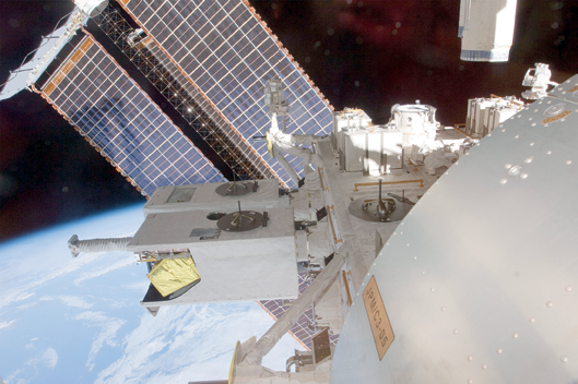
Two U.S. Naval Research Laboratory (NRL) sensors, known as HICO-RAIDS, have been docked on the International Space Station for five years. “We have the distinction of being the first U.S. payload that was attached [there],” says Dr. Scott Budzien, the lead NRL scientist for RAIDS. “We were strongly focused on understanding the temperature of the atmosphere between about 100 km above the surface up to about 150 km above the surface.” Photo is courtesy of NASA.
The second discovery had to do with measuring the electron density of the ionosphere. Dr. Andrew Stephan, an NRL scientist also on the project, “devised a technique by looking at two different extreme ultraviolet bands to make a more precise measurement of the daytime ionosphere.” He and partners at Boston University validated the technique against ground-based radar.
Finally, scientists at Virginia Polytechnic Institute and the New Mexico Institute of Mining and Technology used RAIDS to study nitric oxide (NO). “It’s a thermally important molecule high up in the atmosphere,” said Budzien. “They’re trying to understand how the chemistry of nitric oxide changes through the course of the day and night, and so they used RAIDS data to help refine their model.”
While RAIDS now collects much less scientific data, it’s still useful for understanding how these types of instruments hold up in space. As an example, Budzien’s team learned that RAIDS’ sensitive optical sensors still perform well aboard the ISS.
The Hyperspectral Imager for the Coastal Ocean (HICO) took this image of Christchurch, New Zealand on August 7, 2011. “HICO’s definitely been a really successful transition,” says Dr. Mary Kappus, the U.S. Naval Research Laboratory (NRL) lead. “There’s a lot of overlap in the things we need to understand about the ocean.” Photo is courtesy of U.S. Naval Research Laboratory/Jamie Hartman.
“People were afraid that because of the manned presence and vehicles that come and go all the time, that the environment would be too dirty to collect extreme ultraviolet science data as we do,” he said. “So our experiment contributes to lifetime studies for sensors on the ISS.”
However, Budzien hasn’t given up yet on repairing RAIDS. He’s proposed to build a jack that one of the robotic arms already on ISS could use to “point [RAIDS] at a new altitude that would be more scientifically interesting. And then we could collect more data and do world class science all over again.”
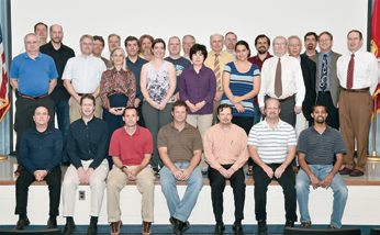
The U.S. Naval Research Laboratory (NRL) researchers who support two sensors, called HICO-RAIDS, aboard the International Space Station celebrated five years of operations in October 2014. “It’s a great team,” says Dr. Mary Kappus, who leads HICO. “Maybe not a lot of money, not a lot of time. You focus, you work hard, and get stuff out.” Photo is courtesy of the U.S. Naval Research Laboratory/Jamie Hartman.
When light shines through water, it reflects and absorbs differently depending on what else is in the water. Said Kappus, “If there’s a lot of chlorophyll it’ll absorb at certain wavelengths, if it’s very clear it won’t absorb at those wavelengths, and so forth. If there’s a lot of sediment, it’ll scatter more at some of the redder wavelengths, which is what makes the water look brown.”
HICO (pronounced “HIGH-co”) captures these variations in light and color with spectra for each point in a picture. Kappus explained, “Hyperspectral means it takes a picture, but for each spot it separates the light into over 100 separate wavelengths.” While more detailed than necessary for open ocean, which Kappus describes as mostly blue, the coast is more complicated. “You’ve got runoff from rivers, you got more turbulence, you’ve got more organic things in the water, and more sediments in the water—and it changes on smaller spatial scales,” she said.
Every day, NRL sends up commands tasking HICO where to take pictures. “We can only take one image on each orbit,” says Kappus, “which gives you about 15 a day maximum.” Some of the tasking supports other NRL projects, NASA sometimes tasks for pictures from a natural disaster area, and many of the tasks come from academia.
“[HICO’s] on the space station, which orbits in a strange orbit,” said Kappus. “You’re at different places, different times—sometimes they’re at angles that are not what you would sensibly choose for imaging.”
NRL looks at how ISS will orbit in the coming week, and “puts out the list of all the opportunities for the coming week, and people say, ‘Oh I want that and that, and that and that.’ And then we have a teleconference once a week to deconflict.”
Kappus mentioned some of the science HICO’s supported, including measuring water flow or velocities remotely. “We have a good [algorithm] in our branch, and so they used HICO data to study a really large area, the whole English channel.” Another NRL scientist worked with colleagues in Russia to measure run-off in the Sea of Azov.
Additionally, she said, “We’ve done a lot of stuff actually just understanding the sensor and signal-to-noise characteristics and changes to radiometric calibration—so really more technical, esoteric things.” She describes remote sensing as a cycle: “We’re interested in the exploitation of the data, but we’re also interested in improving the next sensor.”
Kappus is delighted that, given all the design trade-offs the team made to get HICO built quickly and cheaply (not using space-hardened hardware, for example), that it’s still such a good program. “It’s a great team, not a very big team, which is what works,” she says. “Maybe not a lot of money, not a lot of time. You focus, you work hard, and get stuff out.”
The U.S. Naval Research Laboratory is the Navy’s full-spectrum corporate laboratory, conducting a broadly based multidisciplinary program of scientific research and advanced technological development.
The Laboratory, with a total complement of approximately 2,500 personnel, is located in southwest Washington, D.C., with other major sites at the Stennis Space Center, Mississippi, and Monterey, California.
For more information, visit the NRL infosite at www.nrl.navy.mil/
Story by Kyra Wiens, Naval Research Laboratory
Arabsat’s Dirab Earth Station Gets CID + Monitoring
Arabsat and Siemens Convergence Creators have signed a contract for the installation of a new Communication System Monitoring (CSM) at Dirab Earth Station near Riyadh, Saudi Arabia.
The system will monitor all traffic within the Arabsat satellite fleet and is intended to provide a 24/7 monitoring cycle for the RF & QoS measurements, the characterization, decoding & analyzing of all carriers within the payload. With SIECAMS®, Arabsat will take a major step into a new dimension of satellite monitoring and interference detection and thus improve the quality of their satellite services Thanks to its flexible architecture, the system not only meets the present needs of Arabsat, but is also designed and ready for future requirements.
Furthermore, SIECAMS® was one of the first satellite monitoring solutions available on the market to support Carrier-ID detection, a new technology which enables the identification of the owner of a satellite signal. Both Arabsat and Siemens Convergence Creators are members of sIRG -the Satellite Interference Reduction Group. This new project will combine the strengths of both companies and will lead to a close cooperation for combating and mitigating satellite interference to improve the overall quality of satellite services.
Khalid Balkheyour, President & CEO of Arabsat, said, “Carrier ID is a global, industry-wide initiative aimed at speeding up the resolution of interference and improving the quality of service for all users of satellite communications. ARABSAT is actively involved in the global Interference Mitigation intiatives through its leading role in SIRG & GVF and always strives to use state-of the-art technology to ensure the highest quality services to its customers with current and future satellites.”
Siemens Convergence Creators: www.convergence-creators.siemens.com/
Arabsat: www.arabsat.com/
Moog’s Propulsion Systems Have Galileo’s Orbital Interests In Mind
Moog Inc. Space and Defense Group are enabling the second set of Galileo Full Operational Capability (FOC) Satellites to maintain their orbit 23,222 km above Earth.
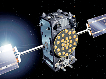
Artistic rendition of a Galileo Full Operational Capability satellite, with platforms manufactured by OHB in Bremen, Germany, and navigation payloads coming from Surrey Satellite Technology Ltd in Guildford, UK. Image Credit: ESA / J. Huart
The satellites, Adam and Anastasia (FM3 and FM4, respectively), launched atop a Soyuz-STB Fregat-MT rocket from Europe’s spaceport in Kourou, French Guiana.
The satellites, manufactured by OHB System AG in Bremen, Germany, are an integral part of Europe’s program for a global navigation satellite system, providing accurate, guaranteed global positioning service, interoperable with the US GPS and Russian GLONASS systems.

The complete satellite system consists of 30 satellites in three planes of Medium Earth Orbit (MEO) and a ground infrastructure.
Moog built the entire Galileo Propulsion System, which includes monopropellant engines, fill and drain valves, latch valves and pressure transducers including the complete thermal control system installation and harnessing.
The propulsion system is a critical subsystem to the satellite, providing orbit maintenance and control capability, support of spacecraft de-tumbling, as well as attitude control in contingency cases (Ultimate Safe Mode).
Moog leveraged the experience gained from the unique Fermi Gamma-ray Space Telescope (formerly GLAST) and critical Landsat Data Continuity Mission (LDCM) propulsion systems with successful launches in 2008 and 2013, respectively, and the high production volume experience from the ORBCOMM Generation 2 (OG2) constellation.
Moog delivered all 14 propulsion systems for the first portion of the constellation, the second batch of eight is currently in the process of delivery.
The complete system design, analysis, qualification, fabrication, test, and delivery of this new system was performed by Moog with sites in both the United States and Europe.
The design incorporates Moog-built components with robust designs and heritage such as fill and drain valves from the United Kingdom; latch valves from East Aurora, New York; pressure transducers from The Netherlands; and thrusters from Niagara Falls, New York.
Final assembly and test is performed at the Niagara Falls facility that has been delivering spacecraft and missile propulsion systems for critical national assets for over four decades.
The Galileo satellites also include fine and cosine sun sensors supplied by Moog. Sun sensors are designed to deliver exact information about the position of the sun. This vital information is used for yaw steering of the spacecraft and therefore applied in earth pointing, solar array orientation and orbit control maneuvers.
The first two Galileo FOC satellites were launched in August of 2014 to an erroneous orbit, due to a launch vehicle anomaly.
The first of the two satellites began maneuvering into its corrected orbit in early November and in its revised orbit after more than a dozen maneuvers using the Moog-provided propulsion system.
The first satellite, although not in the intended orbit, was placed in an orbit that is reduces the damaging radiation from the Van Allen Belts. Once this orbit correction maneuver was verified successful, the same adjustment was made with the second satellite.

The second satellite started making its journey into the corrected orbit in mid-January, performing 14 total maneuvers over six weeks.
The Full Operational Capability phase of the Galileo program is managed and fully funded by the European Union.
The Commission and ESA have signed a delegation agreement by which ESA acts as design and procurement agent on behalf of the Commission.
Moog: http://www.moog.com/