
Greg Mandt is responsible for the success of the GOES-R space and ground developments, launch and on-orbit checkout. This $7.6 billion effort is currently in the early development stage with a projected first satellite launch date in 2015.
Previously, Greg served as the Director, Office of Science and Technology and was responsible for science and technology infusion into the National Weather Service including; science and engineering planning; acquisition and refresh of critical technologies; and the scientific developments of the Meteorological Development Laboratory. Previous assignments in the National Weather Service included Director of the Office of Climate, Water, and Weather Services from 2000 to 2005 and Chief of the Science Branch, Office of Meteorology from 1996 to 2000.
Prior to joining the National Weather Service, from 1992 to 1996, he was the Program Manager and Lead Engineer for the Polar-orbiting Operational Environmental Satellite (POES) Program at the National Environmental Satellite and Data Information Service.
During his 14-year tenure in the United States Air Force, Mr. Mandt held management and executive level positions including; Acquisition Manager of the Defense Meteorological Satellite Program (DMSP); Executive Officer for the Space Systems Division; Chief, Spacecraft Engineering Branch, DMSP Program Office; Research Engineer; Flight Dynamics Laboraory; and Flight Test Engineer.
Mr. Mandt holds a Masters of Science degree in Systems Engineering and a Masters of Science degree in Electrical Engineering both from the Air Force Institute of Technology. He earned his Bachelor of Science degree in Engineering Mechanics from the United States Air Force Academy. He is a graduate of the Defense Systems Management College Program Management Course.
SatMagazine (SM)
Mr. Mandt, first, and most importantly, what does GOES-R offer that is not already operational in other environmental satellites?
Greg Mandt
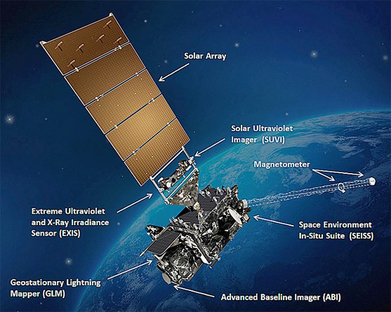
The GOES-R series will offer a significant increase in capability above today’s geostationary satellites. GOES-R will mark the first major technological advance in geostationary observations since 1994 when it launches in late 2015. GOES-R will feature a 16-channel imager—compared with the five-channel imager available on NOAA’s current GOES. This new imager will give us three times more spectral information, four times more spatial coverage, and five times the temporal resolution compared with today’s GOES imagers. This instrument will effectively allow forecasters to “zoom-in” on specific storms and watch them evolve/move in real-time.
GOES-R will also feature a Geostationary Lightning Mapper. This instrument will provide a continuous, near real-time surveillance of total lightning activity during both day and night throughout the Americas and adjacent oceans. This holds great promise for observing the development of severe weather and extending warning lead times.
In addition, GOES-R will include a series of improved space weather instruments. There will be two instruments observing the surface of the sun in the extreme ultraviolet and X-ray spectrums, a suite of instruments measuring energetic particles in the vicinity of the satellite, and another instrument measuring the strength of the Earth’s magnetic field. All of these instruments will have increased sensitivity and a broader range of coverage.
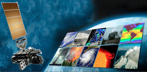
Data from the GOES-R’s advanced instruments will create many different products, helping NOAA meteorologists and other users to better monitor the atmosphere, land, ocean and the sun. This means timelier and more accurate forecasts and warnings.
SM
What is NOAA’s role versus NASA’s role with GOES-R?
Greg Mandt
NOAA manages the GOES-R Series Program through an integrated NOAA-NASA program office, staffed with personnel from NOAA and NASA, co-located at NASA’s Goddard Space Flight Center in Greenbelt, Maryland. NOAA funds, manages and will operate the GOES-R series.
The Program uses NASA Goddard Space Flight Center contracts for the acquisition and development of the GOES-R series spacecraft and instruments and uses NOAA contracts for the acquisition of the ground system and antennas.
The GOES-R Geostationary Lightning Mapper (GLM). Photo courtesy of NOAA/NASA.
SM
What are the satellite’s key functions?
Greg Mandt
Using advanced instruments and sensors, GOES-R’s key functions will be improved capability to monitor weather—from better hurricane track and intensity forecasts, increased tornado warning lead times, to safer and more efficient aviation route planning. Another key function of GOES-R will be advanced space weather forecasting, which includes solar flare warnings for communications and navigation disruptions, more accurate monitoring of hazardous energetic particles and better warning of coronal mass ejections.
SM
How are GOES-R and its instruments being tested prior to launch to determine usability and viability?
Greg Mandt
The GOES-R spacecraft and each of the instruments must successfully complete a series of tests designed to demonstrate that they meet all system functional and performance requirements in all expected conditions, both during launch and on-orbit (e.g., vibration, acoustic, electro-magnetic, thermal, and vacuum). The suite of tests is typical for NASA-developed spaceflight systems, detailed for the mission conditions specific to the GOES-R series satellites.
SM
Given the potential hostilities of space, are there any forms of redundancy built into GOES-R operations?
Greg Mandt
Redundancy is built into the geostationary satellite enterprise currently in place. Today, there are three satellites that provide geostationary weather prediction for the U.S. One satellite covers the eastern side of the U.S., the Atlantic Ocean, and the edge of the coast of Africa.
Another satellite covers the western U.S., including Alaska and Hawaii. A third, fully-capable satellite sits in a “storage” orbit between the other two, in the event it is needed should one or any of the other two satellites, or their primary instruments, not work properly.
After GOES-R is launched and has completed its check out, it will go into an on-orbit spare slot. This redundancy ensures two operating satellites are in place at all times. Satellites are launched, tested, and validated in a staggered manner, so as one satellite reaches the end of its useful lifecycle, another is available to take its place.
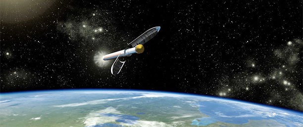
Artistic concept of the Atlas V541 launch vehicle. Courtesy of JPL/NASA.
NOAA also has international agreements and operational procedures in to gain assistance from our partner agencies (EUMETSAT and the Japanese Meteorological Agency—JMA) to provide coverage from their constellations in the event such is needed.
SM
How will GOES-R coordinate its efforts with those of other Earth observation satellites (i.e., NASA’s Aqua and Terra satellites)?
Greg Mandt
Earth observation satellites fall mostly into two types—low-Earth orbits and geostationary orbits. The NOAA Joint Polar Satellite System (JPSS) and NASA’s Aqua and Terra are examples of the low-Earth orbiting satellites. They collect high spatial and spectral resolution information primarily used to feed numerical forecast systems and support climate research/analysis.
GOES-R is a geostationary orbiting satellite providing high temporal resolution information to primarily support severe weather warning efforts. The two types of systems provide complementary data for the Nation’s Earth observation needs.
SM
What launch vehicle was selected to launch GOES-R, given its heavy-weight requirements?
Greg Mandt
GOES-R will launch aboard an Atlas V (541) expendable launch vehicle.
SM
What does the launch schedule look like, as of this writing, and where will the launch occur?
Greg Mandt
The launch of the first satellite in the GOES-R series is currently scheduled for a launch readiness of October 2015. The satellite will lift off from Cape Canaveral Air Force Station, Florida.
SM
Without exceptional ground station support, a satellite is simply another piece of space junk. Would you tell us about NOAA’s ground station operations as it relates to GOES-R, and how does Harris fit into this operational segment?
Greg Mandt
The program is developing a state-of -the-art ground system that will receive data from the GOES-R spacecraft and generate real-time GOES-R data products. The increased capabilities of this new generation of geostationary environmental monitoring satellites require a complete upgrade of NOAA’s ground infrastructure.
Additionally, the program is putting in new data receive antennas at the primary downlink site at Wallops Command and Data Acquisition Center, Virginia, and at the backup facility in Fairmont, West Virginia. The program is also putting in new command and control operations capability for GOES-R at the National Satellite Operations Facility (NSOF) in Suitland, Maryland, where it is also developing a new data processing and distribution system at NSOF.
The Harris Corporation, Government Communications Systems Division of Melbourne, Florida, is responsible for developing the hardware and software components of this ground system. The 10-year contract calls for Harris to design, develop, test, and implement the core ground system functional elements.
Harris was also awarded a separate 10-year contract to supply the ground antenna system. The contract includes design, manufacturing, and testing of six new antennas and upgrading four existing antennas at the three ground station facilities. Harris, under the core GS contract, will integrate the antenna system into the core GS.
SM
How did NOAA select development partners for satellite instrumentation and who are the partners?
Greg Mandt
GOES-R development partners were contracted through a competitive-bid procurement process. The following partners were selected to develop the GOES-R instruments:
- Advanced Baseline Imager: ITT Exelis, Fort Wayne, Indiana
- The Extreme Ultraviolet and X-ray Irradiance Sensors: Laboratory for Atmospheric and Space Physics, University of Colorado, Boulder, Colorado
- Geostationary Lightning Mapper: Lockheed Martin Advanced Technology Corp, Palo Alto, California
- Magnetometer: Lockheed Martin Space Systems Company, Newton, Pennsylvania
- Space Environment In-Situ Suite: Assurance Technology Corporation, Carlisle, Massachusetts
- Solar Ultraviolet Imager: Lockheed Martin Advanced Technology Center, Palo Alto, California
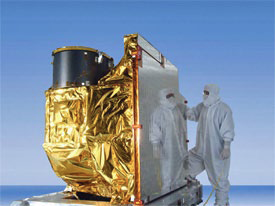
A cornerstone of the mission is the 16-channel ABI instrument, shown above. Photo courtesy of NOAA/NASA.
SM
What instruments are being developed, or have already been developed, for GOES-R? What is each instrument’s purpose?
Greg Mandt
GOES-R will carry three classifications of instruments—nadir-pointing (toward the Earth), solar-pointing (toward the sun) and in-situ (in place).
Two of these instruments point toward Earth—the Advanced Baseline Imager (ABI), which is the primary instrument onboard GOES-R for monitoring Earth’s weather, climate and environment. The ABI will view the planet with 16 different spectral bands, compared with the five on today’s GOES. The ABI channels include: Two visible, four near-infrared and 10 infrared.
With the increased amount of channels, we’ll have twice the spatial resolution, allowing NOAA forecasters to characterize storm intensity and track more accurately, and earlier, in each storm’s development. The ABI is able to provide a continuous full disk view of the Earth every five to 15 minutes and routine coverage of the United States every five minutes. In the surrounding region of a severe storm or tropical cyclone, the ABI will provide images as often as every 30 seconds.
The second instrument pointing toward Earth is the GOES-R Lightning Mapper, which will be the first-ever operational lightning mapper flown from a geostationary orbit. Having an instrument in orbit such as the GLM is critical. While ground-based sensors provide primarily cloud-to-ground lightning strike coverage, the GLM will provide total lightning activity, including in-cloud and cloud-to-cloud, across the entire Americas and adjacent waters, with near-uniform accuracy day and night. In addition to lightning data, the GLM information will provide early indication of storm intensification and severe weather events, helping improve tornado warning lead time and provide data for long-term climate variability studies.
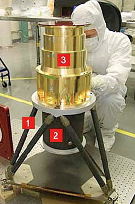
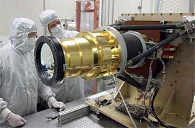
The GOES-R GLM instrument. 1=Sensor Unit Mechancial Support Structure. 2=Metering Tube. 3=Optical Assembly. Photo is courtesy of NOAA/NASA.
GOES-R will fly several advanced solar-monitoring and space weather sensors that will provide vital information to NOAA’s Space Weather Prediction Center in Boulder, Colorado. Two instruments—the Solar Ultraviolet Imager (SUVI) and the Extreme Ultraviolet and X-Ray Irradiance Sensors (EXIS)—pointed at the sun will be incorporated into the Solar Pointing Platform. The SUVI is a high-powered telescope that will observe the sun in the extreme ultraviolet wavelength range. The SUVI will observe and characterize complex, active regions of the sun, solar flares, and the eruptions of solar filaments, which may give rise to coronal mass ejections.
The EXIS will detect solar soft X-ray irradiance and solar extreme ultraviolet spectral irradiance. It will monitor solar flares that can disrupt communications and degrade GPS navigational accuracy, affecting satellites, astronauts, airline passengers and power grid performance.
GOES-R also has two in-situ instruments—the Space Environment In-Situ Suite (SEISS) and the GOES-R Magnetometer—that will monitor their own space environment. SEISS will consist of sensors that track the proton, electron and heavy ion fluxes at geosynchronous orbit.
SM
What new types of imagery will be offered by GOES-R? Could you explain the various “products” that will be available for interested parties?
Greg Mandt
GOES-R will make available 34 meteorological, solar, and space weather products. The GOES-R website lists these “Baseline Products” which are those that are funded for operational implementation as part of the ground segment base contract. There’s additional information at http://www.goes-r.gov/products/baseline.html
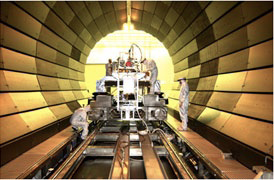
Solar X-Ray Imager Testing in the X-Ray Calibration Facility (XRCF). Photo Courtesy of NASA’s Marshall Space Flight Center.
Additional products may be made available as future capabilities for the GOES-R Series.
SM
What are “Cooperative Institutes” and what is their relationship to NOAA? What resources do they provide to your agency?
Greg Mandt
Cooperative Institutes (CIs) are non-federal academic and non-profit research institutions supported by the National Oceanic and Atmospheric Association (NOAA) that provide resources that support NOAA mission goals and strategic plans. Eight NOAA Cooperative Institutes support GOES-R through algorithm and product development and validation, and user readiness education and training. The CIs supporting GOES-R are:
- Cooperative Institute for Alaska Research (CIFAR) at the University of Alaska, Fairbanks
- Cooperative Institute for Mesoscale Meteorological Studies (CIMMS) at the University of Oklahoma in Norman, Oklahoma
- Cooperative Institute for Meteorological Satellite Studies (CIMSS) at the University of Wisconsin in Madison, Wisconsin
- Joint Institute for Marine and Atmospheric Research (JIMAR), located at the University of Hawaii at Manoa
- Cooperative Institute for Research in the Atmosphere (CIRA) at Colorado State University in Ft. Collins, Colorado
- Cooperative Institute for Research in Environmental Sciences (CIRES) at the University of Colorado at Boulder
- Cooperative Institute for Oceanographic Satellite Studies (CIOSS) at Oregon State University
- Cooperative Institute for Climate and Satellites (CICS)
Scientists from these organizations work with users to understand their operational needs and then develop/modify products which meet those needs.
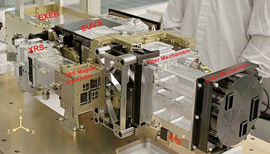
The GOES-R EXIS Engineering Test Unit (EUV + X-Ray Irradiance Senors), which will be mounted in the yoke of the solar array. The subsystems include the Extreme Ultraviolet Sensor (EUVS), the X-Ray Sensor (XRS), EUVS/SRX Electrical Box (EXEB), and the Sun Positioning Sensor (SPS). Photo courtesy of NOAA/NASA.
SM
How will NOAA tackle the need to train users and developers in the use of GOES-R data?
Greg Mandt
The GOES-R Program is committed to providing extensive training for the operational and educational communities that will address both the end users’ and developers’ needs, bridging the gap between research and operations. The intended outcomes of user readiness efforts are day one readiness, maximum use of GOES-R products, and an effective transition to operations.
GOES-R is engaging users early in the process through Proving Ground and NOAA testbed activities, simulated data sets, e-learning training modules, scientific and user conferences, documentation, weather event simulations, special case studies, and other communication and outreach efforts. Training will focus on the quantitative and qualitative use of GOES-R data and products, methods for interpreting GOES-R data, new features, capabilities and algorithms, and a better understanding of atmospheric sciences and mesoscale meteorology in preparation for the future GOES-R Series satellites.
The GOES-R Proving Ground is essential to user readiness. The Proving Ground is a collaborative effort between the GOES-R Program Office, NOAA Cooperative Institutes, NASA, the National Weather Service Weather Forecast Offices, National Centers for Environmental Prediction (NCEP) National Centers, and NOAA test beds across the United States.
The Proving Ground provides testing and evaluation of simulated GOES-R products prior to the launch of the satellites. The simulated GOES-R products are generated using combinations of currently available GOES data, along with higher resolution data provided by instruments on polar-orbiting satellites such as Moderate-Resolution Imaging Spectroradiometer (MODIS) on NASA’s Aqua and Terra satellites as well as model synthetic satellite data.
Many of the GOES-R products will be aimed at monitoring severe weather and helping forecasters issue earlier, more accurate severe weather warnings. In order to create severe weather tools that forecasters have requested, the GOES-R Proving Ground is working with the Experimental Forecast Program and the Experimental Warning Program of the NOAA Hazardous Weather Testbed, developing and utilizing experimental GOES-R products to determine their utility in monitoring and forecasting severe convective weather.
During 2012-2013 GOES-R products have also been demonstrated at the National Hurricane Center, the Ocean Prediction Center, Weather Prediction Center, Aviation Weather Center, Space Weather Prediction Center, and the NWS Operations Proving Ground. The goals of the Proving Ground are:
- Training forecasters to use new products
- Identifying different utilities of each product
- Identifying weaknesses or errors with each product
- User-feedback development
- Day one readiness for GOES-R operations
The GOES-R Program has also implemented the position of “satellite liaison” to prepare forecasters for the data that will be available with GOES-R and to ease the transition to operations. Satellite liaisons are stationed at a number of the National Centers and the NWS Training Center. Satellite liaisons are tasked with running the various GOES-R demonstrations within these testbed locations. They are essentially research-to-operations liaisons, providing training for testbed participants, and providing participant feedback to the product developers for further improvement.
SM
Did sequestration affect any of the NOAA or partner work needed to complete GOES-R?
Greg Mandt
NOAA cannot comment on specific effects of the FY13 appropriation on the program until spending plans for FY13 are reviewed by Congress. We are still assessing impacts of the FY2013 Appropriation to all of our programs. Programs such as GOES-R that are efficiently managed and approaching their launch date are not able to absorb significant adjustments to funding levels without impact. As soon as FY13 spend plans are finalized, we will provide our stakeholders with detailed impacts.
SM
GOES-R will be able to identify weather hazards for aviation… will such include icing projections?
Greg Mandt
GOES-R’s future capabilities include a number of products that can support aviation safety interests including the early identification of rapidly developing clouds, the overshooting tops of maturing intense storms, volcanic ash clouds and sulfur dioxide emitted by volcanic eruptions, as well as regions where icing and turbulence are likely.
SM
What are NOAA’s future plans for additional geostationary environmental satellites? What new capabilities are hoped to be ready for such missions?
Greg Mandt
Behind GOES-R’s currently planned launch readiness date of October 2015, GOES-S is planned to launch in 2017, GOES-T in 2019 and GOES-U in 2024. The entire GOES-R series will extend the availability of NOAA’s operational GOES satellite system through 2036.
GOES-R, The Weather Wonder
More info regarding the program at: http://www.goes-r.gov/mission/spd-welcome.html.