The satellite communications industry continues to wrestle with the undesirable effects of intentional and unintentional interferences on communication signals. The latest strategies for interference mitigation involve new technologies and tools that satellite operators and their customers can use to deal with these effects.

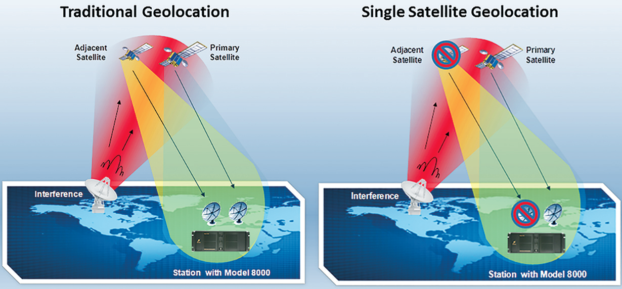
Left: Traditional geolocation using satellite pairs to triangulate an interference emitter (e.g., using a Model 8000 Geolocation Systems). Right: Model 8000-SSG uses only the satellite being interfered with to geolocate, eliminating the problem of not having a usable adjacent satellite while performing geolocation.
Effective ways to deal with satellite interference largely fall into four main categories of strategy: monitoring and detection; geolocating the emitter; removing the interference; and prudent traffic planning. Individually, each of these four strategies may have limited utility against the effects of interference. Together, however, they form a powerful toolset that can minimize and even eliminate the adverse effects of interference, if not the interference itself. Details regarding these four categories follow.
Monitoring + Detection
The SATCOM provider needs to practice continuous cognizance of their carriers through rapidly updated performance and bandwidth availability in order to formulate pictures of the space resources they rely on to serve their customers. This can be accomplished by having a high quality carrier monitoring system that can automatically, or on-demand, scan the carriers/spectrum of interest.
Ideally, the monitoring system should provide as much visibility into spectrum activities as possible at any instant, while gathering specific spectrum performance parameters. To do this, the monitoring system must have a high instantaneous bandwidth (IBW). This will allow the system to rapidly capture a broad swath of spectrum (perhaps even an entire wideband Ka-band carrier).
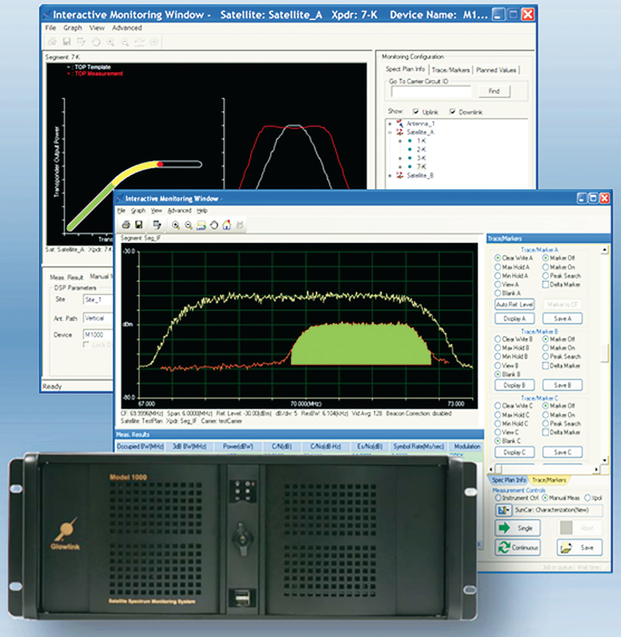
Moreover, interference can be resident adjacent to or buried deep inside a carrier, so it may not be noticed until it becomes a real problem. Imperative is that the monitoring system has high instantaneous dynamic range (typically provided by 14-bit A/D conversion). With a higher instantaneous dynamic range comes a greater capability to expose smaller but potentially troublesome interference signals—a high-quality carrier monitoring system must possess a wide IBW and a high A/D front end, preferably of at least 14-bit. Some systems on the market also have the ability to pick out Interference beneath the authorized carrier without turning off existing traffic—a helpful aid in analyzing the interference and characterizing the possible source without impacting on-going link traffic.
These systems, such as the Glowlink Model 1000 series of carrier monitoring products, possess all of these key attributes. In addition, a unique feature of the Model 1000 is that the product has the ability to assess, in real time, the state of health of a transponder without having to inject tones or measure satellite-transmit EIRP, a performance metric that can be difficult to measure accurately. This capability gives the operator the tool necessary to detect and potentially prevent a potential cause of IM type of interferences: an overloaded transponder.

Locating An Interfering Emitter
A tool able to locate a terrestrial cause of satellite interference, commonly referred to as geolocation, is a must have” element in the battle against communication intrusion. Such is of benefit whether the interference is caused by faulty equipment, unintentional bleed-over from another user, or an intentional interferer.
Traditional geolocation involves triangulation of the interference using two (or more) satellites in close proximity. However, there are two inherent limitations: (1) There may not be any suitable adjacent satellite because of incompatible frequency range or footprint coverage, etc.; (2) An existing carrier on the adjacent satellite is sufficiently strong enough to obstruct the interference’s weaker replica on that satellite. Quite often, (1) and (2) are the root causes for a failed geolocation attempt.
Tools are now available on the market that can help alleviate these limitations. For example, the Glowlink Model 8000 geolocation system can be outfitted with the capability to perform geolocation using only the interfered-with satellite. This capability, marketed as SSG™, operates directly on the interference signal and does not require a second satellite to help locate the emitter. The technology also does not need reliance on databases of known interference emitters, or presumed known characteristics, such as interference Carries ID, should it have one.

Carrier monitoring systems, such as the Glowlink Model 1030, can highlight interference under carrier with 300 MHz IBW and high 14-bit A/D dynamic range. This system can also alert operators to an overloaded transponder, a potential source of IM-type interference. Image courtesy of Glowlink.
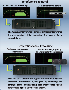
Another interesting tool that can dramatically help with a successful geolocation is the Glowlink GS380L. Working in conjunction with the Model 8000, the GS380L can digitally remove the stronger carrier (without affecting the carrier itself) prior to geolocation, thereby removing the blocking signal and allowing geolocation of the interference signal to proceed.
Together, these products and tools basically ensure geolocation can be run quite successfully.
Removing Interferences
While detection and location of interferences are useful strategies for situational-awareness, often the adverse effect of interferences remains, i.e., there remains interference with the customer’s traffic.
In this case, the ultimate interference mitigation strategy is called for: removing the interference. This idea, while conceptually simple, can be extremely challenging to implement. Fortunately, there are now products on the market that make this strategy possible.
For example, the Glowlink Model GS380X is designed to remove the interference from a communications signal prior to that signal’s demodulation. Based on the company’s patented technology known as CSIR™, the GS380X is designed to remove the interference signal in a real-time streaming fashion. The original signal’s quality is completely unaffected—and in many instances, actually improved slightly—prior to demodulation by the receiver.


