
2021 has been a momentous year for Capella Space and all-weather Earth Observation (EO) with synthetic aperture radar (SAR) technology. Since officially starting our commercial operations in January, the company has served government and commercial customers alike with very high-resolution, ultra-low latency, 24/7, all-weather data to support better decisions.
For the first time in history, Capella Space’s cloud-native approach makes SAR data accessible in an easy and intuitive web application, populated by customer-driven tasking missions with five satellites collecting SAR imagery. As our archive rapidly grows, economic, environmental and geopolitical changes are being experienced.
When Capella was founded almost five years ago, very high-resolution SAR was a rare commodity that was available almost exclusively to specialized governments and research intuitions that possessed large budgets. The company wanted to change that paradigm and make this incredible technology accessible and useful to the many people developing geospatial insights and algorithms with 24/7 all- weather EO data. The firm has officially launched the Open Data Program to the public. This release is a big step in the democratization of SAR, making very high resolution publicly available for the first time.
The Capella Open Data Program
For those following Capella on social media and in the news, you have seen the company’s very high-resolution SAR imagery. The Open Data Program provides access to the underlying SAR data, just as Capella customers interact with our data products to generate insights and analyses.
This community-led effort is designed to give very high resolution, ultra-low latency data directly to researchers, nonprofits, developers and disaster response organizations to foster innovation and discover the next game changing applications of SAR.
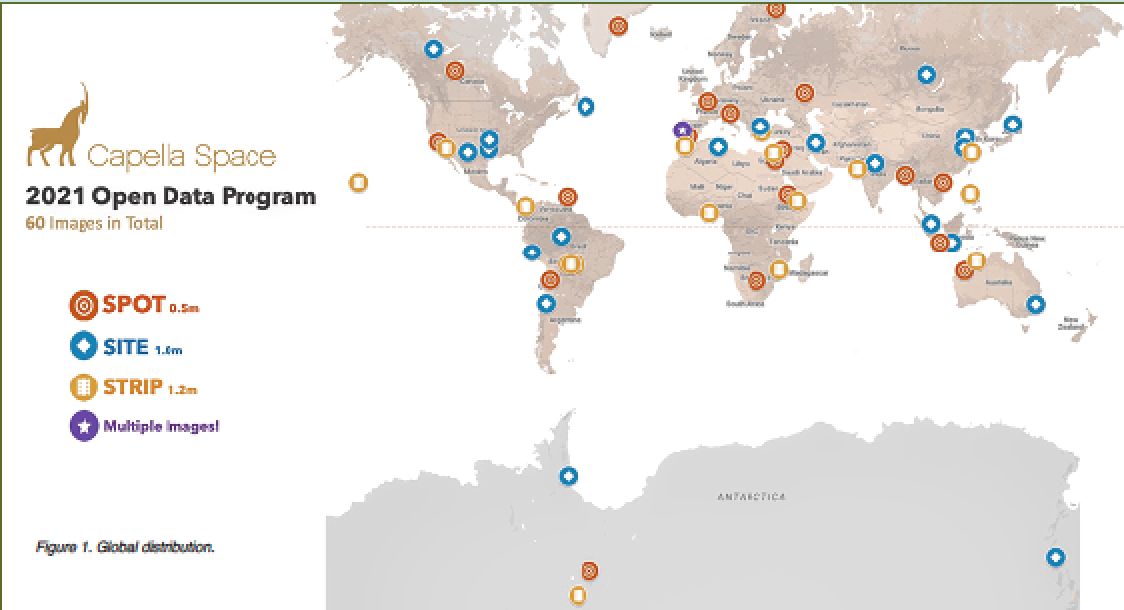
The Open Data Program’s first dataset consists of 60 scenes, covering every continent with examples from agriculture and aquiculture, energy and natural resources, infrastructure, maritime, environmental, as well as humanitarian and natural disaster use cases. Community members will be able to access the data directly through the Capella Console just like an enterprise customer, and access phase and amplitude historical data across all of our SAR Imagery Products — SLC, GEO, GEC and SICD.
Open Data for R&D
These 60 scenes represent a wide variety of geographies and potential use cases, specifically curated to showcase Capella’s products and their utility. This, coupled with an Open Data licensing policy, makes Capella’s data ideal for computer vision and machine learning research and development.
Capella is intent on encouraging and fostering SAR use in the EO community, particularly among those who haven’t worked with imaging radar in the past. Capella provides three imaging modes as products — Spotlight (Spot), Sliding Spotlight (Site) and Stripmap (Strip).
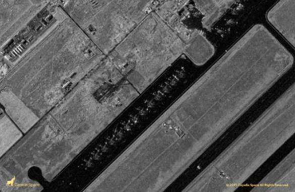
In Spotlight mode, achieving the highest commercial resolution SAR on the market, the antenna beam is focused on a point on the Earth for an extended period of time. Ground resolution is set to be 0.5 meters per pixel, and a special radar processing technique called multi-looking is employed to improve image quality. The swath width of the image is determined by the antenna beam size, yielding a 5x5 km image footprint on the ground. This imaging mode is useful for detecting and counting objects in granular detail such as multiple classes of aircraft, among others.
The Sliding Spotlight imaging mode increases the image length of high- resolution spotlight acquisitions to achieve a 5x10 km image footprint on the ground. Instead of illuminating a fixed point on the ground, as with spotlight mode, the collection angle for Sliding Spotlight is slowly varied to scan the illumination point along the ground. Sliding spotlight provides excellent image resolution (ground resolution is 1 meter/pixel) with larger area coverage than spotlight. For example, sliding spotlight would be a great resource for someone hoping to capture imagery during a flood or hurricane if they didn’t know exactly what region will be impacted and need to look at a wider area.
In Stripmap mode the center of the antenna beam moves in tandem with the satellite. The ground swath is illuminated while the antenna beam is fixed in look angle. This results in an even longer image footprint on the ground at 5x5 km. The ground resolution of the Stripmap is 2 meters/pixel. Stripmap images are useful for identifying land use and change detection of environmental features.
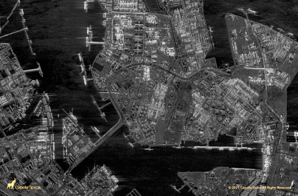
Figure 3. Sliding Spotlight Image of Jurong Island Port, Singapore
Humanitarian Assistance + Natural Disasters
Open data has the potential to positively impact the lives of many people and communities. Synthetic Aperture Radar is particularly suited to capture images during natural and human-made disasters that occlude optical imagery such as Figure 3. Sliding Spotlight Image of Jurong Island Port, Singapore Figure 4. Amazon Deforestation, Luna Camba, Santa Cruz, Bolivia hurricanes, volcanic eruptions and wildfires. This information, when leveraged by emergency response teams, has the potential to save lives, and Capella Space is committed to providing this critical intelligence to those who need it most.
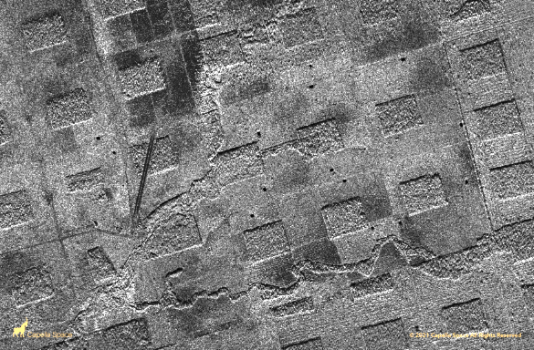
Figure 4. Amazon Deforestation, Luna Camba, Santa Cruz, Bolivia
The company’s initial Open Data Program data includes high resolution SAR data that will become very useful for understanding and responding to humanitarian crises and disasters in real-time. Our first public release includes imagery from the La Soufriere volcano eruption on St. Vincent, the 2021 New South Wales Australian floods and Syrian refugee camps in Jordan, to name just a few.
Community is one of the critical pillars in Capella’s values — new datasets are added as the constellation grows. As natural and human-made disasters occur, the latest imagery to our Open Data Program will be added and information will be shared with first responders for more rapid and efficient disaster response.
How To Access The Data
Accessing SAR data has never been easier. Capella Space has provided imagery previews of 60 images directly in the company website’s SAR gallery. We have outlined three simple steps in order to access the underlying data for each image. Those who access the data will soon be analyzing the highest resolution commercial SAR data and including them in their own applications:

Figure 5. Flooding in Windsor, NSW, Australia. Dark areas indicate inundation
1) Sign up on our community page
2) We will create a user account for you, subject to approval, to access the new Capella Open Data Program Collection
3) Log on to the Capella Console with your credentials and access the entire Open-Data-Program collection


Sign up and join the next generation of SAR users and also explore Capella Space’s Open Data at this direct link...
Author Jason Brown is the Remote Sensing Image Scientist at Capella Space.
www.capellaspace.com