
Demand for high-capacity connectivity and high-speed data and communication services is driving change across the entire satcom industry. Operators are increasingly turning to High Throughput Satellites (HTS) and the even more advanced Very High Throughput Satellites (VHTS). HTS and VHTS operate in higher frequency bands, such as Ka-band and Q/V bands, and allow much higher rates of data transfer than conventional satellites, typically delivering data rates of 500 Gbps – 1 Tbps per satellite.
Alongside using HTS and VHTS, the industry is also increasingly employing non- geostationary satellites (NGSO), whether that be LEO constellations or as part of a multi-orbit system with networks that operate across LEO, MEO and GEO.
Atheras Analytics has developed a suite of AI-based, SaaS-delivered
software tools for designing and operating Ka-band and Q/V-band
satellite networks to mitigate the effects of weather and improve
network and service availability.
By combining orbits, operators can use the specific advantages that each orbit offers, from the wide coverage and high capacity provided by GEO, to low latency offered by LEO. With a multi-orbit system, operators can provide a highly flexible and resilient service that offers just the right level of throughput to meet customer’s needs.
While the push toward HTS, VHTS, NGSO constellations and multi-orbit networks promises unparalleled connectivity, it also creates challenges. HTS and VHTS require multiple gateways to support the substantial payloads, and this considerably adds to ground segment complexities and costs.
Additionally, while the higher frequency bands used by HTS and VHTS offer substantial throughput capabilities, they are also highly susceptible to attenuation caused by atmospheric phenomena with rain being the dominant fading mechanism which can seriously impact service quality and potentially result in loss of service.
Managing Atmospheric Effects
While operators are well versed in mitigating rain fade in legacy satellite systems that use C band, X band or Ku-band networks, the typical fade mitigation tools employed, namely fade margin, adaptive modulation and coding schemes, and uplink power control are less effective at higher frequencies such as Ka-band and Q/V-band.
In these bands the most effective general technique adopted by satellite operators to deal with atmospheric attenuation is to have each primary gateway synchronized with a diversity gateway, so that in the event that one gateway is affected by weather, the traffic can be seamlessly hot-switched to the diversity gateway that is not affected by the same weather event.
It can take between five and 15 minutes to synchronize gateways so, to avoid an outage, it’s standard practice for each primary gateway to have a diversity gateway that is kept synchronized with the primary. This allows it to accept traffic as soon as needed when the primary gateway starts experiencing a problem. While this reactive approach is generally effective in terms of maintaining quality of service, having a diversity gateway for each primary gateway considerably adds to ground segment costs.
An important point to note here is that even before you factor in the inclusion of diversity gateways, ground costs for LEO and MEO constellations are already much higher than those associated with GEO networks because of the need for a large network of full-motion tracking gateways spread across multiple locations.
However, if you’re able to accurately predict weather-related outages before they happen, this gives you time to set up synchronization, and transfer traffic to an alternative gateway, all before the outage occurs.
The benefit of building in this time buffer is that the network no longer requires each primary gateway to have its own permanently synchronized diversity gateway. And if primary gateways share diversity gateways, the network needs fewer diversity gateways overall.
This is the underlying basis for Smart Gateway Diversity (SGD) which significantly lowers overall ground segment costs, while at the same time, enabling satellite operators to maintain the high levels of network availability demanded by their customers.
NGSO Ground Segment Complexities
The ground segment required for NGSO constellations is far more technically complex than that required for GEO satellites because the link and slant path are continuously changing. NGSO networks require a ground segment that is dynamic and flexible, with gateways able to seamlessly switch, track and point, as satellites pass overhead.
NGSO gateways must communicate effectively with each other and with the many satellites that form the constellation. Establishing and maintaining effective communication links for NGSO satellites takes understanding and careful management of link geometries which are dynamic because the elevation- azimuth direction changes during a pass.
With the right tools, operators can gain a comprehensive view of how azimuth angles affect station availability in all directions. More accurate link outage predictions can be obtained by integrating slant path elevation-azimuth geometry into weather-related outage prediction algorithms.
When combined with the ability to predict propagation impairment and weather- related outages, ground stations can be positioned, designed and optimized for enhanced network reliability.
To this effect, Atheras Analytics has extended the proprietary Outage Prediction Algorithm to NGSO links that take into account the azimuth and elevation angle. The link availability is dynamically predicted for all the visible satellites and displays outage predictions.
Using the NGSO-OPA, Atheras Analytics has developed the Polar Link Analysis Tool (PLATo) that visualizes link availabilities, both historic and real-time predictions, on a polar chart
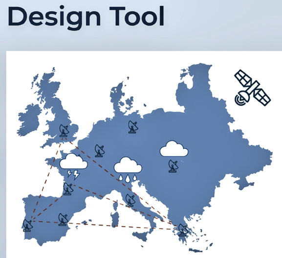
Designing Multi-Gateway Networks

The locations of the gateways used in Ka-band and Q/V bands networks need to be carefully considered because their position will affect gateway availability. Some sites may be particularly susceptible to rain and other precipitation events because of topography. Additionally, it’s also critical that diversity gateways are placed in a position that tends not to experience the same weather as the primary gateway. This is where historic weather data comes in to play, because by analyzing past weather patterns, operators can make informed decisions about network design and positioning of gateways.
Using PLATo, Atheras Analytics analyses five years of historic weather data for not only the actual gateway location but also for weather data points along the slant path for all azimuths and elevations thus enabling network designers to evaluate availability for all slant paths for a given gateway location.
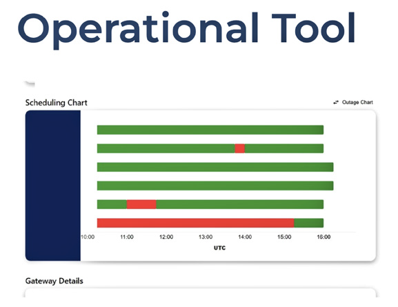
Once in operation, with the use of AI-powered tools capable of predicting outages up to six hours, operators can pro-actively manage simple two- station diversity gateways and more complex Smart Gateway Diversity (SGD) arrangements, by executing traffic switching messages either manually or automatically, all before outages actually happen.
By employing the correct tools at the design phase and combining these with pro-active management of gateways, operators can substantially reduce costs, and deliver the quality of service that customers expect, no matter which orbit they are dealing with.
atherasanalytics.fr
Authors: John Yates is the Managing Director, and Charilaos Kourogiorgas is the Technical Director, both with Atheras Analytics.

John Yates
John Yates has 37 years’ experience in the commercial satellite communications sector. After having completed a BSc(Hons) in Electrical Engineering and Electronics at the University of Nottingham and a post-graduate Diploma in Business Administration at Manchester Business School, in 1986 he joined Europe’s first commercial satellite operator, the recently incorporated SES Astra, in Luxembourg and has been working in the commercial satellite communications sector ever since.Since 1998 he has worked as a freelance consultant and, more recently, as a Board Director and angel investor providing expert advice for companies, organisations and governments worldwide in the commercial satellite telecommunications sector. John co-founded Atheras Analytics Ltd with Dr. Charilaos Kourogiorgas in 2020. John co-founded Atheras Analytics Ltd with Dr. Charilaos Kourogiorgas in 2020.

Charilaos Kourogiorgas
Charilaos Kourogiorgas has a Ph.D. on channel modelling for satellite and wireless terrestrial communication systems for which he received an award for outstanding research, following which he was awarded a Marie Curie fellowship in which he studied the applications of Artificial Intelligence (AI) in the operation of next generation high frequency satellite communications. He has been working for more than 10 years on research and development in satellite communication systems and has applied different AI and ML techniques for channel prediction, ACM optimization and resource allocation for flexible payloads and the use of neural nets in transceivers for real-time modulation and coding of digital information. He has published more than 100 journal and conference papers on wireless communications topics.