Unseenlabs is a French company based in Rennes, Brittany, and founded in 2015 by three brothers — the Galics— who developed a new technology using radiofrequency signals detection — or, space-based RF detection — to geolocate vessels at sea that do not want to be found.

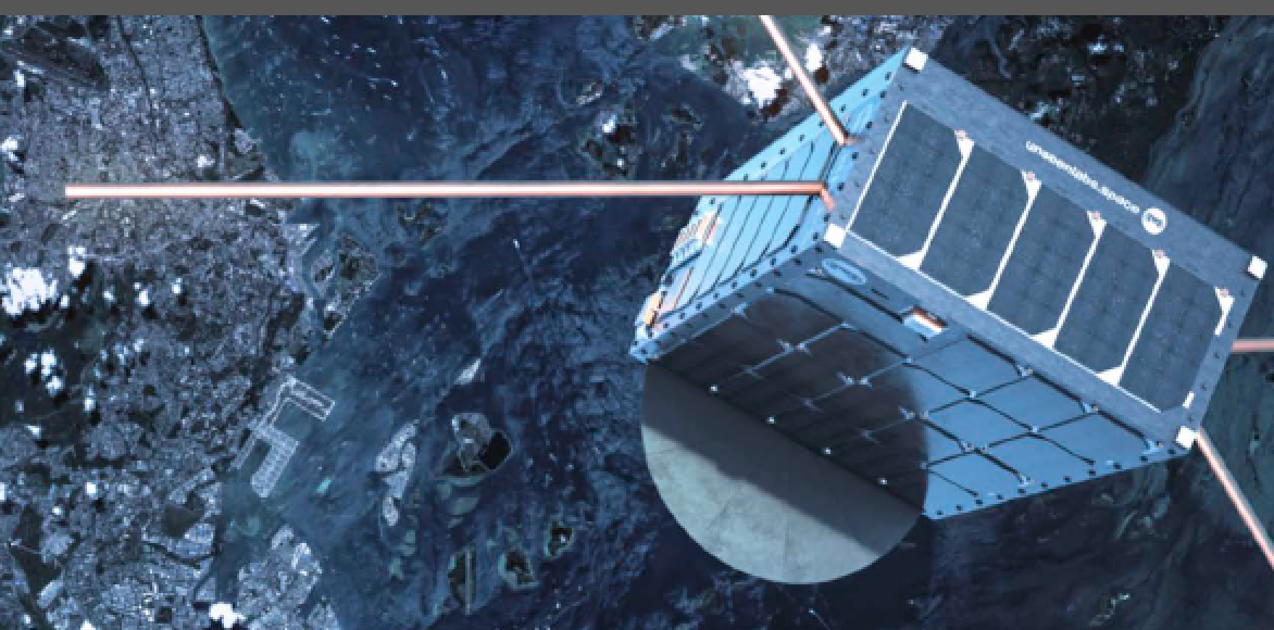
Artistic rendition of Unseenlabs’ BRO-1 smallsat on-orbit, courtesy of the company.
After receiving an award by the French Ministry of Research the year following the company’s creation, a successful fundraising in 2018 allowed Unseenlabs to develop and launch their first satellites. The French company has been fully operational since 2019, and provides RF data to public and private clients.
Unseenlabs uses nanosatellites — also called CubeSats and smallsats — to provide data to the firm’s private and public clients (governments, shipping companies, NGO, etc.) worldwide.
Unseenlabs’ monosatellites constellation specifically detects, characterizes and geolocates RF signals coming from a wide range of emitters. These smallsats cover sea areas of hundreds of thousands of square kilometers.
After a second 20M€ fundraising in April of 2021, and since the launch of BRO-1 (BRO stands for Breizh Reconnaissance Orbiter) in 2019, six additional BROs were launched into space.
In January of 2023 the constellation is comprised of eight satellites. The aim is to further develop the constellation by adding five or six satellites per year: six more in early 2023 and the complete constellation of about 25 satellites on-orbit around 2025.
The Vision
The initial idea for the company was derived from an observation of vessels at sea: there was an extensive lack of geolocation data. That was mainly due to the fact that ships may disappear from radars and become... invisible. This is a serious matter as these invisible vessels may engage in unlawful activities — a non-exhaustive list follows...
• Illegal or undeclared fishing.
• Hostile intrusions in waters under national jurisdiction (exclusive Economic Zone, continental shelf, territorial waters).
• Environmental damages (illegal discharges).
• Destruction of sensitive submarine installations (submarine cables, etc.).

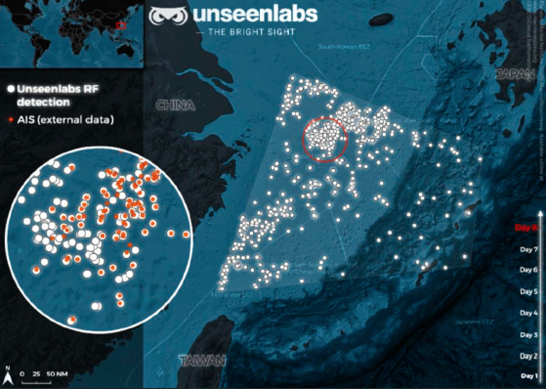
An example of RF data delivered by Unseenlabs technology of the South China Sea (November 2021). In this illustration, note that very few vessels are emitting AIS signals. Unseenlabs satellites present an exhaustive picture of the real estate of the maritime traffic in this zone. Image is courtesy of the company
Our oceans are an invaluable resource in many, many ways: they provide us with food and jobs, they play a key role in climate regulation, harbor more than half of all life on Earth, and they are at the center of the global trading system.
Yet, as the global fleet keeps growing (more than 90,000 ships in the world’s commercial fleet), the lack of precise and up-to-date ship location data leads to environmental and security issues in public and private sectors.
Unseenlabs’ aim is to collect a new type of data in order to help overcome these maritime challenges.
The Technology
Radiofrequency signals detection from space, or space-based RF detection, is the detection by satellites of electromagnetic signals emitted by electronic devices from the Earth’s surface.
Vessels at sea are equipped with many communication and navigation devices that emit — continuously or occasionally — waves that are propagating themselves at a short, medium or long distance.
RF satellites are equipped with very specific receiving antennas and have the capacity to detect these signals on very vast areas. After a sophisticated signal processing, they characterize all these emitters by geolocating them in a precise space-time. Then, they can give any vessel at sea a unique signature — or finger print — to monitor its location in real-time.
Unseenlabs’ one-of-a-kind technology detects every ship emitting radiofrequency signals with or without an active location beacon, regardless of the time of day and weather conditions or maritime areas covered. With seven satellites, the current revisit time on a zone is around six hours (three hours in 2023 and less than 1 hour in 2025). The geolocation accuracy is close to the nautical mile (2 km).
The Markets
Unseenlabs maritime surveillance service provides players of the maritime world with accurate and up-to-date data on marine traffic.

From States willing to better control their territorial waters to fishing companies wanting to monitor their areas of activity, Unseenlabs collects crucial data for public and private actors, efficiently characterizing all forms of maritime activity and detects emergency situations as well as illegal or suspect behaviors with great reactivity.
Unseenlabs’ operational capacity has major application areas in the following defense and security policies (non-exhaustive list):
• The fight against malicious or hostile activities and intrusions in waters under national jurisdiction (Exclusive Economic Zone, continental shelf, territorial waters).
• The fight against terrorism at sea and piracy.
• The protection of the offshore installations (oil rigs, wind farms).
• The protection of the main sea routes and sensitive submarine installations (submarine cables, pipelines, underwater acoustic systems, etc.).
• The fight against illegal or undeclared fishing.
Unseenlabs’ goal is to provide essential data to help its clients in many ways: protection of the oceans, safeguarding of their waters, assistance of vessels in distress, monitoring of maritime traffic, etc.
Unseenlabs’ Service
►
On January 3, 2023, Unseenlabs successfully launched the company’s eighth satellite that is dedicated to the geolocation of vessels at sea from space (launch photo above). BRO-8 was launched with Exolaunch as part of SpaceX’s Transporter-6 Mission from Cape Canaveral, Florida. Communication with the satellite was successfully established a few hours after launch. In total, Unseenlabs has now deployed eight satellites since 2019. The Unseenlabs constellation is designed to provide customers with reliable and frequent radio frequency data for rapid detection and monitoring of activities at sea, regardless of the time of day, or weather conditions. This capacity is ideally suited for applications such as national security, insurance and marine area protection. To date, Unseenlabs has built and launched the largest fleet of independent satellites dedicated to the detection of radio frequency signals. The technology created by the company helps its customers to gain the most up-to-date analysis on maritime traffic for their area of interest. In 2023, the French SME plans to expand the team based at its headquarters in Rennes, France. Additionally, the company plans to increase the number of spacecrafts to reach a constellation of 20 to 25 independent satellites, dedicated to the geolocation of vessel at sea from space. “The new satellites add essential capacities to the Unseenlabs constellation: it means more solutions and deeper analysis for our customers. If you need to know what is happening in your areas of interest, Unseenlabs provides you with an efficient solution for an exhaustive view of maritime traffic through maritime surveillance”, Clément Galic, CEO and cofounder of Unseenlabs adds.
UNSEENLABS offers a geolocation data service with a characterization of maritime emitters worldwide and is available for any sea area all around the globe. This service is operational and covers all the Earth’s oceans.

A satellite pass over a planned reference point covers large sea areas. With seven satellites, the current revisit time on a zone is around six hours (three hours in 2023 and less than one hour in 2025). The geolocation accuracy is close to the nautical mile (2 km).
Furthermore, the geolocation detection works for all commercial navigation radars, regardless of transmission power or specific parameters. Unseenlabs’ maritime operational image enables an immediate detection and characterization of all the radars at sea that do not emit AIS signals, or those whose AIS parameters are inconsistent (spoofing, for example).
To conclude, Unseenlabs’ data allows to (for Defense and Security):
• Determine patterns of life on poorly known or unknown areas.
• Expose and characterize aggressive activities or phenomena (illicit or undeclared).
• Follow vessels of interest for intelligence or action purposes.

