In just a few years, Low Earth Orbit (LEO) networks have gone from rare to one of the main alternatives for telecommunication infrastructures. LEO networks offer a wide range of use cases, from government users to media houses, from NGOs to consumers, fundamentally changing the satellite communication industry and applying pressure on Geostationary (GEO) network owners to upgrade their customer experience.

The satellite communication market has profoundly changed in the past five years since the debut of SpaceX’s own LEO constellation. However, this is in no means bad news for GEO networks. On the contrary, at Satcube, we have seen this as a tremendous opportunity for GEO constellations to renew and upgrade their services.
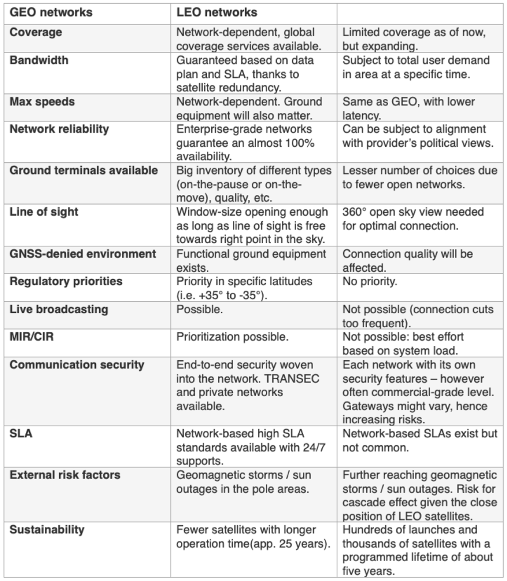
Important to keep in mind is that LEO constellations are not just an improved version of GEO — there are some key differences between the two networks that are crucial to know about in order to select the correct orbit for your needs. Review the key takeaways and comparison table included in this article to learn more about what differentiates GEO and LEO networks to assist in making an informed decision.

Constant Connections Versus Speeds
From a user standpoint, one of the main differences between GEO and LEO networks is the quality of the connection one receives. LEO networks usually boast higher speeds and lower latency; however, the link will break regularly during satellite handover. How long that connection interruption lasts can vary, but it can be as much as a few seconds.
Takeaway #1: It is important to consider if you need a constant link, which is what a GEO network will offer (for example, for a live broadcast) or if higher up and down link speeds are more important, in which case LEO might be a more appropriate choice.
Coverage Area
Given the difference in altitude (about 36.000km vs. 500km above Earth), the number of satellites needed to offer global coverage varies immensely. Where three satellites could, technically, suffice for GEO, one would need thousands of small satellites for a global LEO network.
Intelsat and Starlink are a couple of good examples: Intelsat offers global coverage (except for the poles), thanks to 22 GEO satellites and they are enough to provide overlapping coverage, allowi for redundancy as well as the freedom to choose what direction to point an antenna in denser areas.
On the other hand, Starlink has already launched close to 6,000 satellites by April of 2024 but coverage is still limited to the Americas, Europe and Oceania. Starlink does not yet provide broadband coverage over most of the African or Asian continents (and that’s also due to a lack of ‘official’ approvals).
Important to note is that there exist priority rules for networks in specific latitudes where GEO constellations have priority — LEO terminals are not allowed to transmit toward the GEO arch. As a result, coverage and speeds will be degraded for LEO networks for latitudes from about +35° to -35°.
Takeaway #2: Check coverage maps and average speeds for different locations and constellations, especially if you’re going to be working around the equatorial line.
Line Of Sight
Consideration must be given as to what type of geographical environment the terminal will be located to enable satellite connectivity. LEO terminals require an open sky view, ideally at 360°, for a maximum speed connection, as the terminal needs to follow the satellites over their orbit until their elevation gets too low and a connection switch is made to a following satellite.
One downside to this is that LEO terminals will be visible from the sky. As far as GEO is concerned, especially in regard to Communication-On-The-Pause (COTP), then the requirement would be to have a free line of sight toward one fixed point in the sky — even an open window would then be sufficient for terminal to satellite and vice versa connectivity.
Takeaway #3: Research how the geographical conditions are expected to be locally and how easy or difficult it might be to have a good enough line of sight to have a functioning satellite broadband connection on either orbit type.
GNSS-Denied Environments
If the location for connectivity is the scene of an ongoing conflict, chances are there will be disruptions to GNSS-signals. As LEO terminals need to locate the closest/best satellite and synchronization requirements must to be accurate, GNSS signals are needed for this connection to function.
On the other hand, not all GEO terminals have that limitation, as those synchronization requirements are more relaxed (as everything is stationary), meaning higher-quality terminals can function independently of GNSS-signals
Takeaway #4: Going to a conflict-ridden area? Check out a GPS-jamming map and choose your orbit and ground equipment accordingly!
“At Satcube, we develop state-of-the-art terminals that offer stable and global connections, even in situations with limited line of sight or GNSS-jamming, to deliver the best possible user experience. This is one reason why our first terminals focused on GEO networks. With that said, we are also looking to expand our offering to the LEO orbit as we always have our end-users in mind when developing products and services and believe that this would be a great add-on to our portfolio,” said Jakob Kallmér. “If there are any questions, please contact us.”
satcube.com