
Mission Maneuverings Mustered By SSL For nbn™
October 6th was an important day for Space Systems Loral (SSL) and nbn™ — the SkyMuster II mission was launched after a one-day hold, due to weather conditions, and gained the assigned orbital slot without difficulty.
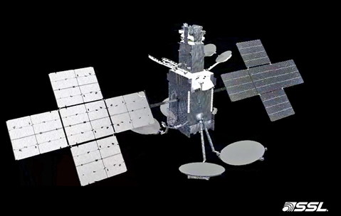
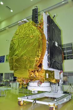
Artistic rendition of nbn’s SkyMuster II satellite is courtesy of SSL.
Sky Muster™ II, which is the second high-throughput satellite (HTS) that SSL has designed and built for Australia’s national broadband network (nbn™), has successfully performed all post-launch maneuvers according to plan.
The satellite’s solar arrays were deployed on schedule following the launch aboard an Ariane 5 launch vehicle from the European Spaceport in Kourou, French Guiana.

The satellite fired the main thruster early in the morning in order to propel the spacecraft toward the craft’s final geostationary orbit.
nbn will use Sky Muster™ II in conjunction with their first satellite, Sky Muster™, to provide high-speed broadband service to more than 200,000 Australians. Similar to the first nbn satellite, also built by SSL and launched last year, Sky Muster™ II is a Ka-band, high-throughput broadband satellite (HTS) that uses multiple spot beams in an advanced design that optimizes bandwidth for Australia’s widely distributed population.
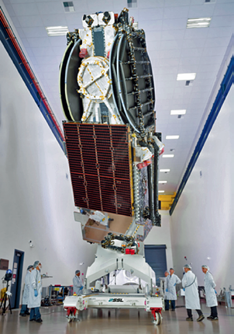
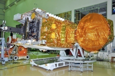
nbn™’s SkyMuster II satellite during the final build process at SSL’s manufacturing facility. Photo is courtesy of SSL.
Together, these two satellites provide advanced services to Australia’s most difficult to reach citizens, including those in mainland Australia as well as those on offshore islands including Norfolk Island, Christmas Island, Lord Howe Island, Cocos, and Macquarie Island in the Antarctic.
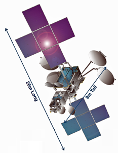
Sky Muster™ II is based on the SSL 1300 platform, which provides the flexibility for a broad range of applications and advanced technologies.
According to John Celli, the president of SSL, the two nbn satellites are quite sophisticated and complex HTS that will bring broadband Internet to people that can’t be reached by Australia’s fiber, cable, and wireless networks. SSL commended nbn on the implementation of their vision, which is to improve the quality of life for so many Australians.
Bill Morrow, the chief executive officer of nbn, added that the two SkyMuster satellites will help bring essential services, such as telehealth, video-conferencing, and distance education, to people in regional and remote Australia.
www.sslmda.com
www.nbnco.com.au
GSAT-18 Gains 74 Degrees East Groove
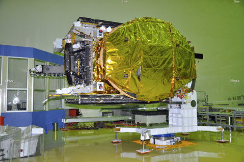
The GSAT-18 Spacecraft undergoing test at ISITE Bengaluru. Photo is courtesy of ISRO.
India’s latest communication satellite GSAT-18 was launched on October 6th by Ariane-5, a heavy duty Arianespace rocket, from the spaceport of Kourou in French Guiana.
GSAT-18, built by the Indian Space Research Organisation (ISRO), aims at providing telecommunications services for the country by strengthening ISRO’s current fleet of 14 operational telecommunication satellites.
The fully Integrated GSAT-18 Spacecraft in the clean room at ISITE Bengaluru. Photo is courtesy of ISRO.
The European launcher Ariane-5 VA-231 blasted off at around 2:00 a.m. (IST) and injected GSAT-18 shortly after orbiting co-passenger Sky Muster II satellite for Australian operator nbn (National Broadband Network) in a flawless flight that lasted about 32 minutes.
GSAT-18 aims to provide telecommunications services for the country by strengthening ISRO’s current fleet of 14 operational telecom satellites and gained a Geosynchronous Transfer Orbit (GTO) about 32 minutes after lift-off.
“GSAT-18 successfully launched by Ariane-5 onboard Flight VA-231 from Kourou, French Guiana,” Bengaluru-headquartered ISRO announced after the mission.
GSAT-18 undergoing Reflector Deployment test. Photo is courtesy of ISRO.
GSAT-18 is the 20th satellite from ISRO to be launched by the European space agency and the mission is the 280th for Arianespace launcher family.
ISRO, which has been dependent on Ariane-5 rocket for carrying its heavier satellites, is developing their own GSLV Mk III launch vehicle for such activities.
Weighing 3,404 kg at lift-off, GSAT-18 carries 48 communication transponders to provide services in Normal C-band, Upper Extended C-band and Ku-bands of the frequency spectrum.
The designed on orbit operational life of GSAT-18 is approximately 15 years.
www.isro.gov.in/
One Year Of On Orbit Success For AstroSat
The Indian multi-wavelength space astronomy observatory AstroSat completed one year on orbit as of September 28, 2016.
The spacecraft has orbited the Earth more than 5,400 times and has executed 343 individual pointings to 141 different cosmic sources.
Several celestial sources have been observed and studied in detail. The satellite is functioning normally and all of the payloads are operating as originally planned.
AstroSat observes the universe in optical, near and far ultraviolet and X-ray regions of the electromagnetic spectrum. The interesting feature is the simultaneous multi-wavelength capability on the same satellite platform. These studies are being extended by co-ordinated observations using other spacecrafts and ground-based observatories.
The first six months were dedicated to performance verification and onboard calibration of payloads indicated, which has shown that all the payloads conformed to the designed parameters.
The first set of scientific observations were completed from April to September 2016. Some of the salient science observations include:
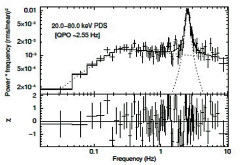
• Large Area X-ray Proportional Counter (LAXPC) has observed rapid variability of high energy (particularly >20keV) X-ray emission from a black hole system, GRS 1915+105 for the very first time.
The figure above reveals the power density spectrum for the source GRS 1915+105. As seen in the figure, Quasi periodic oscillations (QPOs) at 2.55 Hz are observed in the energy band 20 – 80 keV for the first time. This QPO changes in frequency as the flux of the source changes.
LAXPC also measured the arrival time difference between the high and low energy X-rays (which is of the order of tens of milli-seconds). This provides direct clues to the geometry and dynamic behavior of the gas swirling around a spinning black hole (Ref: arXiV:1608.07023 [astro-ph.HE]).
The Cadmium Zinc Telluride Imager (CZTI) normally operates in the energy range 15 – 100 keV. At higher energies, the Field of View of this imager becomes wide and it can detect Gamma Ray Bursts (GRBs). These are transient gamma ray events that can occur at any time, in any part of the sky, and are considered to arise at cosmological distances beyond our Galaxy.
CZTI has detected more than 40 GRBs. CZTI has demonstrated capability to detect polarization in GRBs.
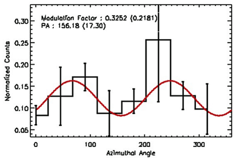
The figure on the next page shows the identified events corrected for geometry contributing to the GRB 1510016A (in black) as a function of azimuthal angle. The red solid is the fit to the modulation curve. The fitted modulation factor is 0.32 with the detection significance of 1.5 sigma.
The scientific details will be published shortly in the Astrophysical Journal (Ref : arXiV:1608.07388 [astro-ph.HE].
Polarization properties and their relation to the spectral evolution have potential to clearly distinguish between various models of GRB prompt emission mechanism Polarization estimates are being undertaken for Crab and several other X-ray sources.
• Ultraviolet Imaging Telescope (UVIT) observed the field stars in the open cluster NGC 188. One source which was earlier thought to be a sub-dwarf is found to be a binary with sources having temperatures around 12500K and 5750K.
• Scanning Sky Monitor (SSM) observed the X-ray pulsar 4U0115+63 in its outburst phase and the pulsations of 3.6 seconds were detected.
• Soft X-ray Telescope (SXT) detected the continuum and lines from bright Supernova Remnant such as Tycho. The advantage of having a good spectral resolution along with large field of view is expected to be extremely important to study the clusters of galaxies.
Regular satellite tracking and data processing is being done at ISRO. The data is distributed to the scientific community by the Indian Space Science Data Center (ISSDC).
ISRO, in collaboration with IUCAA, has established an AstroSat support Cell (ASC) at IUCAA (astrosat-ssc.iucaa.in/), Pune, to consider long term scientific support for AstroSat as well as to train young scientists to explore the numerous possibilities for proposal submission and data analysis. Details on the science meeting organized at IUCAA to commemorate the one year completion and the posters released during the event are available at the ISRO website (isro.gov.in/update/29-sep-2016/science-meet-to-commemorate-one-year-of-astrosat-orbit).
An Act Of GRACE By Airbus Defence & Space
The build has now been completed by Airbus Defence and Space on the GRACE-FO (Gravity Recovery and Climate Experiment, Follow-On) satellites in Friedrichshafen, Germany, with the satellite to now be transferred to Ottobrunn near Munich for several months of operational testing in the IABG test center.
NASA’s Jet Propulsion Laboratory (JPL) will send both GRACE-FO research satellites into a polar orbit at an altitude of around 500 km and at a distance of 220 km apart.
This is a follow-on to the GRACE mission, which has been successfully in operation since 2002.
As they travel around the Earth, these satellites constantly take very exact measurements of their separation distance, which changes depending on the Earth’s gravity.
In this way, scientists are able to map the Earth’s gravitational fields.

A global positioning system and a microwave ranging system enable the distance between the satellites to be measured to within one micron.
The GRACE-FO satellites will feature an additional element: a new inter-satellite laser ranging instrument, developed by a German/American joint venture, which will be tested for use in future generations of gravitational research satellites.
Launch of the GRACE-FO twin satellites is planned for no earlier than late 2017.
Over the course of the five-year mission, measurements will be taken to provide an updated model of the Earth’s gravitational fields every 30 days.
In addition, each of the satellites will supply up to 200 profiles of temperature distribution and water-vapor content for the atmosphere and the ionosphere on a daily basis.
The second GRACE-FO satellite will be ready for testing in about four weeks.
GRACE-FO is a partnership between NASA and the German Research Centre for Geosciences (GFZ).
airbusdefenceandspace.com/
How Serendipitous For EUMETSAT
Thought lost forever, but now found, are 40-year-old satellite images that will significantly add to the understanding of the Earth’s climate.
The data, from the European Space Agency’s (ESA) prototype Meteosat-1 geostationary meteorological satellite, was found at the University of Wisconsin-Madison’s Space Science and Engineering Center (SSEC) in the United States.
The imagery has now been provided to EUMETSAT, which operates and disseminates data from Meteosat-1’s “descendants” and, crucially, has an uninterrupted record of climate data from these satellites stretching back more than 30 years. That record, although with a small gap, the discovery extends even further back in time.
To say that the discovery of this lost data was greeted with enthusiasm would be an understatement, with climate scientists describing it as “like finding a lost child”— “the first born”!
Meteosat-1 was launched on November 23, 1977, and was positioned in a geostationary orbit at 0 degrees longitude, with a constant view of most of Europe, all of Africa, the Middle East and portions of South America.
From that position, this view of the “full-disk” was scanned every 30 minutes, with the data being provided in near-real-time to users. The satellite’s mission lasted until November 25 , 1979.
At the time of Meteosat-1’s on orbit present, such represented cutting-edge technology and introduced the concept of a global system of geostationary platforms capable of observing the atmospheric circulation and weather around the equator in near-real-time.
This was also the first geostationary meteorological satellite to have a water vapor channel, tracking the motion of moisture in the air.
The data found in the US comprises 20,790 images, from December 1, 1978, to November 24, 1979.
On June 27, 2016, EUMETSAT held an event to celebrate the organization’s 30th anniversary, in Darmstadt, Germany. Among the guests was Dr. Paul Menzel, Senior Scientist with the Cooperative Institute for Meteorological Satellite Studies, part of the University of Wisconsin-Madison’s Space Science and Engineering Center.
A memento received by guests at that event was a memory stick with links to EUMETSAT’s climate data record, from January 1, 1984, up until this anniversary in 2016—that’s more than 32 years.
“It was pointed out that the data was all there, except for two days, which were missing,” Dr. Menzel said. “That prompted me to have a look whether we had the data for those two days. When I went back, we started looking for the data but I was told we didn’t have any Meteosat data from before 1992. I knew that couldn’t be right.”
The SSEC Data Center didn’t have the data for the missing two days but did find something even more valuable.
In 1978 to 1979, the First GARP (Global Atmospheric Research Program) Global Experiment (FGGE) was undertaken, a project reported by New Scientist at the time as the biggest cooperative international venture ever undertaken.
The project was to find out which gaps in global weather monitoring could be filled to improve weather forecasting seven to 10 days in advance.
Meteosat-1 data was provided to the SSEC for this project. The center’s founder, Verner Suomi, often referred to as the “Father of Satellite Meteorology,” had the foresight to recognize the importance of preserving Earth Observation (EO) data.
“I thought we must have the FGGE data,” Dr. Menzel said. “Vern’s mentality was, I don’t want to lose any of the data.”
Dr. Menzel’s colleague, CIMSS Program Manager Dr. David Santek said teams of experts had worked in three shifts around the clock tracking cloud features in the images from the 1,200 nine-track tapes of Meteosat-1 data that was shipped to them for the FGGE project in 1978-79.
“Then those tapes sat around for 20 years,” Dr. Santek said. “In 1997, we started converting data from old tape media on to more modern media. We could not dispose of those old tapes. From 2001-2004, new nine-track tape drives were acquired to extract most of the data from the tapes and, over the past 15 years, the original data were stored on disk, although without any attempt to use it.”
That’s why the old data were able to be found. However, finding the data was not the end of the story. The files were stored on disk in the original tape format and needed to be decoded.
Dan Forrest, SSEC’s Senior Systems Engineer, spent several weeks piecing the files together, dug up old documentation, wrote a decoder and was able to retrieve the data, but it was not quite usable. In another serendipitous twist, D.r Santek was the person who wrote some of the original code and he provided modules for navigating and calibrating the data.
EUMETSAT Climate Services and Product Manager Dr. Jörg Schulz said the discovery would not only provide a longer time series of climate data but would be reanalyzed and reprocessed using the latest methodology.
“[This data] gives us information about the state of the Earth’s atmosphere from a time when there was less interference from human activity,” Dr. Menzel added.
Dr. Schulz added this find would help further improve understanding of the Earth’s climate system. “One of the grand challenges in climate science is to better understand atmospheric circulation in general,” Dr. Schulz said. “Where is the tropical, warm, moist air going? Where is the polar, cool, dry air going? And how does this change over time? This data will be very important to support the analysis of position, strength and variability of storm tracks as well as circulation-cloud interactions.”
The three scientists were keen to stress the scientific and historical importance of the data as well as how this demonstrates the value of strong collaboration and cooperation.
www.eumetsat.int