
Interference is a problematic issue that causes significant impact to satellite communications and sometimes makes a satellite frequency spectrum unusable.
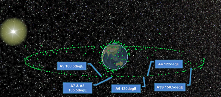
Figure 1. A graphic illustration of the AsiaSat Fleet’s orbital slots1
When satellite operators experience interference, they may have to relocate their customers to a temporary frequency slot for service recovery until the interference issue is resolved. In some cases, commercial satellite operators have to pay outage compensation to their customers, incurring unnecessary revenue loss. In addition, the non-salable frequency spectrum that occurs due to interference will limit profit growth and business development.
The effectiveness of using assigned spectrum resources in outer space is a major goal to maintain the success of an operator. To achieve this goal, geolocation is a practical and proactive method to both locate the source of interference and to help tackle interference issues.
Figure 1 is an illustration of the orbital slots of the AsiaSat Fleet in space. Considering the geostationary arc between the longitude 95 degrees East to 125 degrees East, there are 28 commercial communications satellites in service. Note that the average satellite separation is only 1.1 degrees, which makes the work to minimize interference quite challenging. Uplink Adjacent Satellite Interference (ASI) can be an issue for the satellite networks operating with communications satellites in such close proximity to one another not properly coordinated and managed.
Interference Types And Mitigation
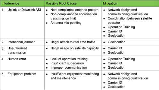
With the growth in the number of satellite networks, and if network qualification and activation are not properly executed, the probability of interference increases. Satellite operators are facing different types of interference threats every day and they can be classified into five main categories:
1. Uplink or Downlink ASI
2. Intentional jammer
3. Unauthorized transmission
4. Human error (ground antenna mispointing, incorrect frequency, polarization, power, bandwidth or transmission time)
5. Equipment problem (noise pickup, oscillator drift or other spurious activity)
Depending on the root cause of each type of interference, some suggested mitigation methods are summarized in the table on the next page.
Geolocation is applicable in the mitigation method to all the main interference types.
Geolocation Approach
Dual Satellite Geolocation (DSG)
A conventional geolocation approach is the so-called Dual Satellite Geolocation (DSG). This solution uses the technique of time difference of arrival (TDOA) and frequency difference of arrival (FDOA) multilateration described in [2].
When an uplink antenna (Interference Source) transmits a signal to a satellite (Primary Satellite), this uplink antenna is also transmitting a copy of the signal in a lower power level to a nearby satellite (Secondary Satellite). The power level of the signal copy toward the Secondary Satellite depends on the uplink antenna size. The larger antenna size has smaller antenna beamwidth, and hence its off axis gain toward the nearby satellite will be smaller. A smaller antenna will be vice versa.
Due to the difference in the signal propagation path of the two satellite links, the downlink antenna systems of the primary and secondary satellite observe a different time delay for the received signals. The resulting differential time offset (DTO) gives partial location information of the interference source. (Green line in Figure 2)
In the real situation, the two satellites are moving with respect to the ground station and each other. Therefore, the downlink antenna systems see a different Doppler shift in the frequency of the signals received. The resulting differential frequency offset (DFO) provides additional location information. (Red line in Figure 2)
Based on the position data of the two satellites, i.e., the ephemeris data, together with the DTO and DFO information, a line of position (LOP) can be computed and defined. By taking measurements of the DTO or DFO at different times, additional LOPs can be retrieved. Finally, the intersect point of the two LOPs indicates the estimated location of the uplink interfering station.
AsiaSat published a paper in 2012 that presented the application of a DSG system, satID, to detect sweeping interference with support from SAT Corporation [4]. The geolocation principle of satID is shown in Figure 2, below.
Single Satellite Geolocation (SSG)
Another approach is the Single Satellite Geolocation (SSG) method. The main advantage of this method is that only one satellite is required for the geolocation. This means it has less limitation on the geolocation application because it does not require two satellites to provide parameters for interference source calculation.
One existing implementation available in the market is applying the concepts from quantum information theory for the algorithm process to find the best matching carrier to detect the interference source location.
Another possible way is to track the interference for longer periods, e.g., over a 24 hour cycle, for collecting more measurement samples in the correlation calculation, assuming accurate ephemeris information is available. In Q1 2016, Siemens Convergence Creators announced they would start the implementation of their single satellite geolocation solution (SIECAMS ILS ONE) to Eutelsat [3].
Geolocation Considerations
Geolocation is widely used in the industry for interference mitigation. In order to effectively facilitate the capability of this solution, the considerations below have to be thoroughly studied.
1. Measurement uncertainty
Result accuracy of geolocation is the most important parameter to be evaluated for reliability justification. It is well known that the accuracy of geolocation depends mainly on the Ephemeris error and achievable processing gain of the carrier signal to noise ratio. The ephemeris will be heavily depending on the ranging data collected from the operator. In general, operator requires two to three days of ranging data to determine the satellite drift and position information.
Also, when the satellite itself is equipped with electric propulsion system for maneuver control, the actual ephemeris will be continuously changing during the thruster firing period. Depending on the type of electric propulsion, the firing duration for each maneuver can last from one to six hours for twice a day. At this specific occasion, the actual ephemeris would not be available for geolocation.
Conventional chemical propulsion duration is comparatively much shorter than that of the electrical propulsion. However, this does not mean that the satellite with electric propulsion is not suitable for geolocation. The only consequence is the measurement accuracy on the geolocation during the electric thruster firing period.
The processing gain of the correlation Signal-to-Noise Ratio (SNR) depends on the interference SNR on the primary and secondary satellite. The SNR on the secondary satellite depends on the receive G/T of the interference location at the secondary satellite coverage and also its uplink antenna size.
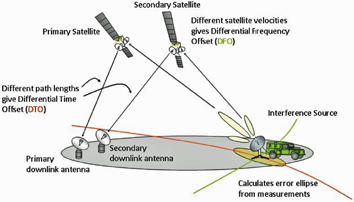
Figure 2. Geolocation Principle of satID.
2. Compatible adjacent satellite
In order to have the signal copy from a secondary satellite perform correlation calculation, an adjacent satellite that receives and retransmits interference uplink in the same polarization and geographic area as the interference is required. However, this condition may not be always met in a real situation. For example, a satellite with multi-spot beams coverage in Ka-band may not be able to find an adjacent satellite with overlapping geographic beam coverage in the same frequency band. Without a compatible adjacent satellite, DSG detection is not possible.
3. Reference sites
To correct the ephemeris error and the geolocation system measurement uncertainty, the typical method is applying reference sites information to calibrate the results. It should be noted that this information may not be available at the time of geolocation. It is because the other customer uplink locations (i.e., potential reference sites) on the same polarization as the interference may not be within the secondary satellite coverage. Also, the reference site carrier towards the secondary satellite may not have enough SNR for a good correlation calculation.
When good reference sites information is not available, the operator would need to set up on their own site. All they need to do is to setup a carrier uplink at a location which can provide transmission toward the primary satellite as well as radiating to the secondary satellite by its side lobe at the same time in order to provide useful information to the geolocation calibration. The more information available will be more favorable to the calculation. As time is required to setup the ground reference, the interference may be gone at the time for the geolocation measurement. A systematic database for searching customer uplink information is essential to help the reference sites information support.
4. Latest and accurate ephemeris data
Usually, the secondary satellite available for DSG is not owned by the primary satellite (i.e., the one suffering from interference) operator. Hence, getting the latest detailed ephemeris data of the secondary satellite may be difficult.
In most cases, we can only rely on the public two line element (TLE) data as the geolocation result input. This information is limited and sometimes being out-of-date. If accurate ephemeris data is available, it will be beneficial to the correlation calculation.
Consider the AsiaSat fleet—AsiaSat 5 (100.5 degrees East) and AsiaSat 7 (105.5 degrees East) have an orbital separation of 5 degrees. These two satellites are acting as a good secondary satellite to one another for geolocation in both C- and Ku-band. Similarly, AsiaSat 4 (122 degrees East) and AsiaSat 6 (120 degrees East) have an orbital separation of 2 degrees, which is also an optimum adjacent satellite pair for geolocation in C-band. Taking this advantage in the orbital slots, AsiaSat can manage its own internal resources for more accurate and quicker geolocation application and does not require other operators’ satellite information.
5. SSG Application
With the new and innovative technology available, geolocation may not be solely dependent upon the conventional DSG method. Some products, by using single satellite geolocation, have been available in the market for operator implementation.
To provide better understanding of interference to the satellite community, the best solutions for providers is for there to be more demonstration regarding a product’s capabilities. Therefore, when DSG is not possible, the satellite operator can have an alternative solution to tackle interference. If the achievable accuracy of SSG can be enhanced as the level of DSG, a satellite operator can have an alternative and a more cost effective solution at hand.
As interference mitigation is critical in maintaining high service quality and in protecting a customers’ networks, AsiaSat is willing to partner and contribute to advancing geolocation technologies within the industry. The company is also committed to providing an interference free environment and ever better service to all customers and affiliates. Although satellite interference cannot be predicted, AsiaSat believes the occurrences of interference can be reduced through the joint efforts of the satellite industry community.
Reference
1. AGI online application for viewing real-time satellites. Analytic Graphics Inc. Retrieved from http://apps.agi.com/SatelliteViewer/
2. P. C. Chestnut, "Emitter Location Accuracy Using TDOA and Differential Doppler," IEEE Trans. Aerosp. Electron Syst., vol. AES18, no. 2, pp. 214-218, Mar. 1982.
3. Press release, “Eutelsat to Implement SIECAMS® ILS ONE for Advanced and Simple Geolocation.” Siemens Convergence Creators GmbH. Retrieved from http://www.convergence-creators.siemens.com/eutelsat-siecams-ils-one-satellite-geolocation.html/
4. Application of a Dual Satellite Geolocation System on Locating Sweeping Interference, http://www.asiasat.com/sites/default/files/Application-of-a-Dual-Satellite-Geolocation-System-on-Locating-Sweeping-Interference.pdf
Paul Chan is AsiaSat’s Spacecraft Engineer. He received the B.Eng. Degree in Electronic Engineering from the Chinese University of Hong Kong in 2004 and the MSc. Degree in Telecommunications from the Hong Kong University of Science and Technology in 2008. Mr. Chan has over 10 years of experience in satellite operations and engineering. He is responsible for technical evaluation of satellite payload systems design and performance.