
Accurate and timely forecasts are key to today’s space weather forecasting.
As commercial operations and national defense become increasingly dependent on satellites and satellite connectivity, the ability to accurately predict space weather will be paramount — collecting and analyzing data and key information about space weather can help commercial and government entitities manage the risks for satellite launches, operations and infrastructure, optimize the success rate of launches and further strengthen the resilience of satellite networks.
Last December, scientists from the National Oceanic and Atmospheric Administration (NOAA), the National Aeronautics and Space Administration (NASA), the U.S. Air Force (USAF), and the National Science Foundation (NSF) announced a new collaborative approach to improve space weather forecasting and services.
This agreement is a direct result of the Promoting Research and Observations of Space Weather to Improve the Forecasting of Tomorrow (PROSWIFT) Act, which was signed into law in October of 2020.

These initiatives underscore the far-reaching impacts that space weather can have on critically important satellite infrastructure and operations. Furthermore, they reflect a growing momentum in the public and private sectors to enhance space weather forecasting.
Challenges To Space Weather Forecasting
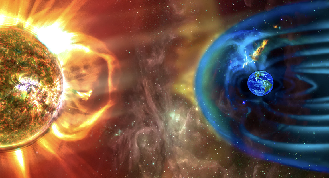
The term “space weather” refers to variable conditions in space and on the sun, which can dramatically influence the performance of satellites and impact technology on Earth. For example, radiation storms and ionospheric disturbances can disrupt a satellite’s ability to operate and communicate. Orbital drag also reduces Low Earth Orbit (LEO) satellites’ longevity.
In spite of the significant influence of space weather on critical satellite systems, space weather predictions are often incomplete or inaccurate.
Modeling space weather is an immensely complicated task, involving extremely diverse processes. Physical processes occurring millions of miles away may catalyze an event that impacts Earth minutes or even hours later. As scientists strive to better understand, analyze and forecast space weather, they must account for interactions between the lower atmosphere, the ionosphere, the magnetosphere and the solar wind.
Scientists have created models of the ionospheric electron density to predict impacts on communication, navigation and surveillance systems. Models can also be used to forecast satellite drag, which is extremely useful for predicting satellite orbits in the LEO environment.
With modern advancements in supercomputing and data analytics, great strides have been made across the space industry to better understand space weather patterns. As computers have become faster and more capable, it has become possible to simulate the space environment in more detail on finer spatial and temporal scales and to do it in real-time.
One of the biggest challenges in understanding and predicting space weather is obtaining relevant environmental measurements at the times and locations where they are needed.
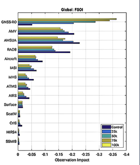
Comparison of observation impacts for OSSE experiments with additional GNSS Radio Occultation (GNSS-RO) observations on the 24-hour forecast error growth using Forecast Sensitivity Observation Impact (FSOI). Experiments include 25000, 50000, 75000, or 100000 additional GNSS-RO soundings per day compared to a Control scenario. GNSS-RO show large beneficial impacts with 25000 or more additional observations compared to other spaceborne or in-situ data types. Chart: NASA.
To address this challenge, scientists are working to develop space weather sensors that include remote sensing capabilities that span the entirety of the electromagnetic spectrum, from HF radio waves to ultraviolet light. These sensors may be ground-based or space-based, and the data they collect can be used to create and augment advanced space weather models.
In comparison to meteorological measurements, space weather measurements are incredibly sparse. The disparity between space weather and meteorological forecasting capabilities is due to the vast regions of space that need to be monitored, versus the relatively small area represented by the surface of the Earth for meteorology.
Simultaneously, with advances in sensor technology and new measurements made from space, scientists have also learned a great deal about the physical processes that drive space weather. With these technological breakthroughs, the space weather industry is making great strides toward quickly, accurately and reliably forecasting space weather.
Key Considerations To Enhance Space Weather Forecasting
To accurately simulate and predict space weather, many more measurements are required to help constrain current space weather models. In the past, during the discovery phase of space weather, sparse measurements were tolerableb as little was known about the various regions of space. There has since been a realization that additional distributed measurements from smaller and lower-cost satellites are necessary to help constrain and inform space weather models.
With cutting-edge data and modeling tools, mission managers can operate spacecraft more efficiently and safely through improved orbital analysis. Satellite locations can be tracked in various ways, such as via GPS or direct observation from radars or telescopes, and then their locations can be assimilated into models, in the same way that data are ingested into meteorological models.
Operators can then use the model’s specification of the space environment to predict their own satellite orbits and the orbits of other objects they may be interested in, such as space debris.
Space weather models can also enable scientists, mission managers and decision-makers to study different mission scenarios and understand the potential impact of new sensors before they are acquired or deployed. Such studies are known as Observation System Simulation Experiments (OSSEs) that consist of simulated data from potential future sensors to determine the value of that sensor. OSSEs can be tailored for a specific space-related mission, such as satellite orbit prediction or HF communications.
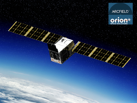
Orion Space Solutions , a wholly owned subsidiary of Arcfield, launched
an Electro-Optical/Infrared Weather System (EWS) Satellite for U.S. DoD.
OSSEs provide quantitative assessments for Analysis of Alternatives (AoA) studies. With access to these critical insights, government agencies and commercial entities can save valuable costs and resources by preventing the deployment of unnecessary or redundant sensors and optimizing the deployment of future sensors.
Progress Requires Cross-Sector Coordination
Nearly seven decades into the space age, space weather forecasting is becoming a reality; however, further research is needed to deepen humanity’s understanding of space weather, and its impact on civilian, commercial and defense missions.
To continue driving innovation and improving space weather forecasting capabilities, it’s imperative to foster productive interactions between the research community and the operational community. As such, the PROSWIFT Act mandates “promoting opportunities for research-to-operations and operations-to-research collaborations both within and outside of the federal government.”
Thorough, consistent communication between academic institutions, government agencies and commercial entities will be essential to improving the flow of information between the research and operational communities.
There may be national security and cybersecurity concerns about satellite communications or operations — matters of national defense are undeniably paramount — and, therefore, collaboration between sectors should always prioritize security and privacy while not entirely stifling cross-sector communication.
Organizations such as the American Commercial Space Weather Association (ACSWA), and legislation such as the PROSWIFT Act, are pivotal steps in the space weather sector that will drive collaboration and lead to enhanced forecasting capabilities.
Comparison of observation impacts for OSSE experiments with additional GNSS Radio Occultation (GNSS-RO) observations on the 24-hour forecast error growth using Forecast Sensitivity Observation Impact (FSOI).
Experiments include 25000, 50000, 75000, or 100000 additional GNSS-RO soundings per day compared to a Control scenario. GNSS-RO show large beneficial impacts with 25000 or more additional observations compared to other spaceborne or in-situ data types. Chart: NASA.
Experts in the industry may also consider hosting or participating in forums, roundtables, workshops and conferences to further support space weather collaboration and information sharing, as appropriate.
Quite apparent is the space weather industry is poised for significant growth during the coming years, which is fortunate considering Solar Cycle 25 is already proving to be more active than originally predicted.
As scientists continue to design and deploy cutting-edge sensors, digital models, and data analysis algorithms, we will be able to better understand and mitigate the effects of space weather phenomena on our daily lives.
Orion Space Solutions , a wholly owned subsidiary of Arcfield, launched an Electro-Optical/Infrared Weather System (EWS) Satellite for U.S. DoD.
https://www.arcfield.com/