The value of space exploration, beyond science, inspiration, and adventure, is bolstered with the application of space technology here on Earth. Interplanetary exploration is more commonly seen as a matter for pure science, but Israel based Utilis (with offices in San Diego and the UK) has well and truly pushed beyond non-stick pans and microcomputers, to bring a technique developed for hunting Martian water to bear on pressing environmental issues here on Earth.
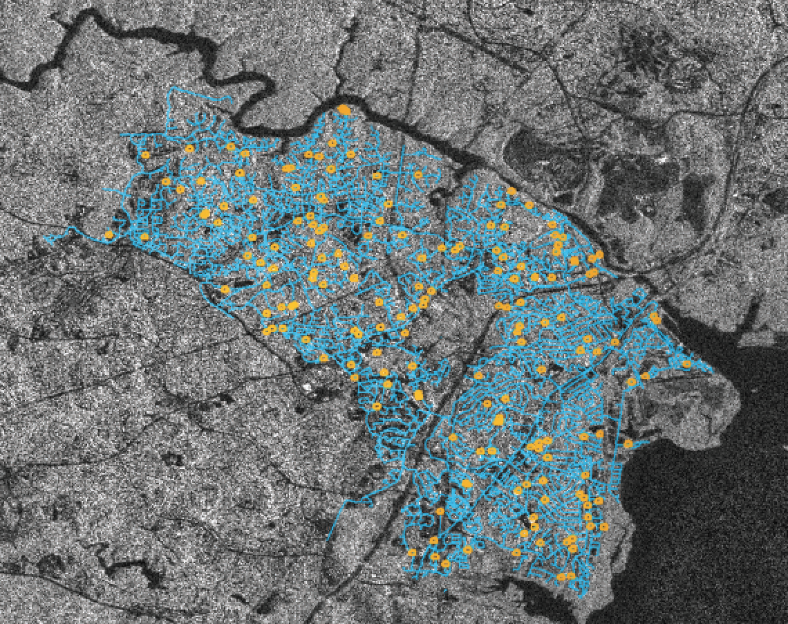 SAR image with pipe layers (blue) overlayed, and likely leak locations circled (yellow), demonstrating how Utilis can save a utility time by only highlighting the areas with leaks. ©JAXA All Rights Reserved Distributed by PASCO CORPORATI
To date, Synthetic Aperture Radar (SAR) companies have focused on launching SAR satellites for use in applications such as foreign intelligence data gathering for defense agencies or for fintech applications (e.g., counting car numbers at shopping malls). Utilis is distinctive in that they are targeting a mainstream market - water utilities - using SAR data from existing spacecraft to help countries around the world fight water loss.
Rather than aiming to establish another SAR constellation, Utilis have focused on processing downstream SAR data into concise product solutions, which are far more intuitive for network operators. They combine information derived from soil moisture levels, into a GIS-based data set identifying likely leak locations of drinking water pipes, providing an assessment across entire networks. Following a period of rapid growth in recent years, Utilis now plans to deploy their talents in additional infrastructure markets such as wastewater, dams, and transportsystems, including roads and railways.
Utilis was founded in 2013 and has understandably attracted great interest from water utilities across the world, due to the resource and cost savings they can offer via their services. The company has so far completed more than 400 projects worldwide, finding over 30,000 leaks, saving more than 27 million cubic meters of water and 11,000 metric tonnes of carbon dioxide emissions per year. In this time, they have grown to 40 employees working out of their three offices.
Despite the challenges of the past year, they have expanded in 2021 with a new office in central London, and recently attracted $6 million of new investment from Anglo-American venture capital fund Beringea. The funding is being used to accelerate the growth of the business just as Utilis has brought a new product, MasterPlan, to market.
With five years of leak detection behind them Utilis have been able to develop a new algorithm used for their MasterPlan pipe deficiency product. This enables MasterPlan to assess the efficacy of an entire pipe system from a stack of SAR data. The dataset can then be imported into a risk model containing other data on pipe materials, age of the structure, and even recorded maintenance. MasterPlan provides a direct insight into actual pipe conditions across a wide area, as opposed to predictive or AI produced products. It is a GIS data file and can integrate with any geographical information system to improve utility mapping of network health and asset planning.
SAR is a remote sensing technology that was first conceived of during the Atlas program in the early fifties. With SAR, microwaves are transmitted at a planetary surface and the reflections received like conventional radar; however, the SAR technique exploits the motion of its transceiver to effectively create a much larger “synthetic” reception area.
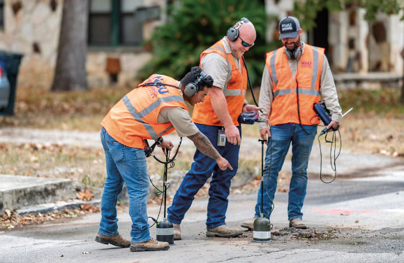
A field team pinpoints a leak provided by a Utilis-
provided point of interest.© Utilis Corp
In addition, the reflected signal encodes more than simply distance information, with variations in intensity and polarization providing insights into the nature and constituents of the reflective surface. SAR spacecraft can transmit specifically in horizontal or vertical polarizations, depending on the specific sensor. Hard substances, and particularly humanity’s love of right-angle corners, preserve transmitted polarizations; whereas vegetation and softer soils can scatter the polarization, leading to return signals that are distributed between horizontal and vertical antennas. It is this aspect of L-band SARs that enables Utilis to penetrate the ground, and not only spot moisture, but the specific characteristics of treated water.
Using commercially available data streams from SAR instruments already on orbit, Utilis have been able to avoid the major potential barrier of having to launch actual bespoke spacecraft. In addition, they have taken an unusual direction within the SAR imaging sector in their focus directly on utilities; something they are building on this year with a move into broader infrastructure. The same techniques can be used to better manage infrastructure located in areas with damaging soil moisture beneath.
Utilis was founded by physicist Lauren Guy who, after completing a bachelors in Geomorphology and Remote Sensing at Ben Gurion University, had pursued a Masters in Atmospheric Physics and Dynamics at The Hebrew University in Jerusalem. There he studied the application of SAR for mapping moisture in Martian soil.
Following these studies, he became aware of the ubiquitous problem of water loss from global water supply networks. Some estimates suggest that up to 46 billion liters of treated water are lost per year, and water utilities lose an average of between
20 to 35 percent of their flow rate to “Non-revenue water” or NRW. NRW wastes an increasingly precious resource and leads to significant energy inefficiency. Traditional leak hunting is slow and expensive, having to work pipe-by-pipe, but Guy realized the techniques developed to survey Mars from orbit could provide the means to conveniently map water leaks quickly and efficiently.

Utilis is a wonderful example of how “blue sky,” or perhaps in this case “red sky,” research can unexpectedly bring massive environmental benefits back to Earth itself.
utiliscorp.com
Author Karen Dubey has worked with synthetic aperture radar since 1997, when as a senior scientist at NOAA she researched derived solutions from RADARSAT-1. Her career has focused on product development and communicating real world earth science issues. She is a certified project management professional (PMP) with expertise in product management and market strategy. She is currently the Corporate Marketing Director for Utilis, based in San Diego.