The demand for instant, high speed, global communications services, including cellular (mobile) phones and in particular the Internet, has led to the concept of low-Earth Orbit (LEO) systems—they would operate at an altitude of 700 to 1400km and possess a polar orbit. At an altitude of 700km, the surface area to be reached by a satellite would be about 3000 x 3000km.
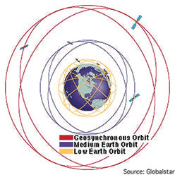
However, to provide global (or, in some cases, regional) coverage from a lower altitude requires more satellites. They must communicate with one another to achieve long distance communications. Moreover, with the satellites moving within their orbit, users must constantly (automatically) switch between satellites, a similar approach used by navigational satellites.
Three separate markets for such satellites have been identified:
– Those providing mobile data messaging and position determination services, referred to a Little LEOs
– Those providing mobile voice and fax services, in addition to the Little LEO services, known as Big LEO
– Those providing wireless video, voice, and broadband, high-speed data services to small satellite dishes, known as Mega LEO
The orbits of these proposed systems vary in altitude, inclination, as well as the number of orbital planes to provide coverage for the desired markets.
Many of the systems that were proposed were merely at a conceptual level, with the stated intent of gaining financing before proceeding to hardware. As such, many of the proposals never moved any further than that crucial money stage. Being unable to obtain financing, these projects disappeared into the waste paper basket before their plans could be preserved for historical purposes.
This article discusses some of the proposals that managed to move somewhat further than just the “this is a good idea” stage and where sufficient documentation survived the route to the disposal bin.
The proposals, especially those requiring large numbers of satellites, were beyond the existing capacity of the space launch industry at the time of inception. This resulted in many proposals for the establishment of additional launch sites around the globe as well as the need for more cost efficient launch vehicles.
It became quite clear that the market was simply not large enough for all of the proposals to result in finished product. Noteworthy is that some leaders used legal processes to hinder potential competitors by challenging competitor licenses, with the objective of handicapping any potential competitors and to place itself in a preeminent competitive position.
Mega LEO Systems
There were three so-called mega systems that relied, initially, upon a large number of satellites. None of these systems ever materialized.
Teledesic
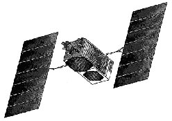
Teledesic, proposed by the company of the same name, was the first of the Mega LEO broadcast constellations and was announced in 1994. At that time, the constellation was to consist of 21 near-polar orbital planes of 40 active satellites each, making a total of 840 satellites, excluding four in-orbit spares per plane. The satellites would orbit at a 700km altitude and all were to be operational by 1999.
In April of 1997, Boeing acquired a 10 percent ownership in Teledesic and would become the prime contractor to build and launch the Teledesic Network. Boeing proposed to reduce the constellation to 288 satellites through the use of new technology. The reworked satellites would have been placed in 12 near polar planes of 24 satellites each, with three spares in each plane and an orbital altitude change to 1375km.
The major launch vehicle for the network was to be the Sea Launch Zenit 3 vehicle.
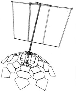
Each satellite would have resembled a flower with eight “petals” and a large boom-mounted square solar array. The deployed satellite would have been 12m in diameter and the solar array would have been 12m per side.
Each petal was to consist of three large panels containing the phased array antennas. The octagonal baseplate also supported eight pairs of intersatellite link antennas to allow the satellite to link with its nearest neighbors. The baseplate also supported two satellite bus structures that housed the engineering subsystem components and propulsion thrusters. A third satellite bus structure, containing power equipment and additional propulsion thrusters, was mounted at the end of the solar array boom.
The satellites would have operated in the Ka-band and this constellation was scheduled to start operations in 2002.
On February 26, 1998, a 45kg technology demonstrator was launched. The satellite, identified as Teledesic T-1, used a Microstar platform and carried a transponder operating in the Ka-band. The satellite was slotted into a 535 x 580km orbit, with an inclination of 97.7 degrees.
In July 1999, the Teledesic constellation was further modified to eventually consist of 30 Medium Earth Orbit (MEO) satellites as the projected market demand continued to decrease. In July of that year, Lockheed Martin was contracted to provide launch vehicles, either Proton or Atlas 5, and three launches with each of these vehicles were booked, along with five future launch options with each of these vehicles.
By then, Motorola, a company that had merged its Celestri program with Teledesic in May 1998, was seen as the main contractor for the satellites, an arrangement that lasted until October of 2000.
In February of 2002, Teledesic announced that the first two satellites would be built by Alenia Spazio—the assumption was that the remainder of the satellites would also have been manufactured by that company. However, in September of 2002, construction was halted and development was suspended on October 1, 2002. Teledesic’s staff was reduced to 10 employees. In July of 2003, Teledesic surrendered its frequency licenses.
While Teledesic may still exist as a corporate entity, there is currently no evidence of any activities.
Sativod/SkyBridge
Sativod (for Satellite Video On Demand) was a 64 satellite system using the Ku-band proposed by Alcatel Espace in 1995. The constellation would have used two overlapping constellations of 32 satellites, each consisting of four planes of eight active satellites per plane. The first 32 satellite constellation were to be placed in orbit by 2001 and the second by 2002.
The satellites would have been at an altitude of 1469km with an inclination of 54 degrees. In February of 1997, the system was redesigned as SkyBridge and the number of satellites was increased to 72, with 8 spares.
The launch of the first 40 satellites was to be handled by two Delta 3 launch vehicles carrying four satellites each, and four Delta 4 Medium+ (5,4) launch vehicles carrying eight satellites each. These launches were to occur in 2001.
Alcatel also contracted with Starsem, a Russian-European company formed in 1996, to launch 32 satellites, with ten Soyuz ST/Fregat launchers carrying three satellites each, and an 11th with only two satellites. These would have taken place in 2002/2003. It was envisaged that the system could accommodate the traffic that would be generated by more than 20 million users.
In 2001, Alcatel placed the plans on hold as it was unable to raise sufficient financing for the system. By 2003, the rights to the SkyBridge system were acquired by SES Global. The intellectual property was merged with the SES Satlynx proposal for two way satellite broadband access services.

Celestri
Celestri was a 63 communications satellite system proposed by Motorola in 1997 and was a combination of an earlier LEO constellation of 72 satellites proposed by Motorola as M-Star and a four satellite GEO constellation developed under the name Millenium.
The LEO system would have consisted of nine planes of seven satellites and placed into orbit with an altitude of 1400km, with an inclination of 48 degrees. Up to seven in-orbit spares would probably have been launched, as well. The system would have been supported by nine geostationary satellites.
Through intersatellite links, Celestri would have formed a toroidal mesh network around the Earth. Launches were envisaged to take place in 2001 and the system was to be fully operational by 2002.
The satellites themselves would have been 12.7m in length with a mass of 3100kg—based on conceptual designs. However, on May 21, 1998, Motorola sold the concept to Teledesic and became a prime contractor in that undertaking. There is evidence to suggest that the development of the satellites was outsourced.
The “Biggies”
Of the proposals for Big Systems, some of which were to operate in the Low Earth orbit, only two, Iridium and Globalstar, became operational.
Iridium started as a 77 satellite system—when the systems became operational, the constellation had been modified to 66 satellites in six polar orbits to provide global mobile communications services. The first Iridium satellite was launched on May 5, 1997. The Globalstar system, led by Loral Space & Communications, consisted of 48 satellites and the first was launched on February 14, 1998. Both companies still operate, although they have re-structured at various times.
Other systems, some less than successful and canceled, follow…
AMSC
Mention must be made of the American Mobile Satellite Corporation (AMSC) system that planned to have two satellites in geostationary orbit. This system was started in 1989 when AMSC was authorized to construct, launch and operate satellites to provide mobile services to the US and Puerto Rico. AMSC teamed with Telesat Mobile Inc., a Canadian company, and two satellites were launched and placed in geostationary orbit on April 7, 1995 and April 20, 1996. The system has also been referred to as MSat. The company has had various restructures before adopting the name SkyTerra and, ultimately, LightSquared.
Constellation
The Constellation system, proposed by a company with the same name, was to use 46 satellites to provide global coverage and would have consisted of 11 satellites in an equatorial plane to provide continuous service to tropical regions as well as 35 satellites in seven inclined planes for complete global coverage. The satellites were expected to have been built by Lockheed Martin and the system was expected to be in operation by the year 2000. The company no longer exists.
Ellipso
The Ellipso system was to be a 16 to 18 satellite network providing, principally, services to the northern latitudes (above 25 degrees North latitude) for United States, Canada, Europe, the Middle East, the former Soviet Union, China, Korea and Japan coverage. Reduced services would also have been provided down to the 50 degrees South latitude. Ellipso would have achieved this coverage by placing as many as 12 satellites in inclined elliptical orbits of 500 x 1250km, with an inclination of 63.4 degrees, and up to six satellites in an equatorial orbit.
The proposal was advanced by Ellipso Inc. (also referred to as Ellipsat Inc.) in 1997. The first two satellites were to be built by Mobile Communications Holdings, Inc. (MCHI), a subsidiary of Ellipso Inc.—MCHI entered into a construction contract with Boeing on July 17, 1998. However, by 2002, the company was struggling financially and a number of patents that the company held were put up for sale.
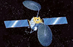
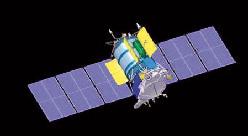
The ICO-2 satellite. Photo courtesy of Boeing.
ICO
ICO Global Communications was initially a subsidiary of Inmarsat and was later renamed New ICO, They proposed a constellation of 10 satellites in a MEO orbit of 10,390km with an inclination of 45 degrees, which would have been placed in two planes of five satellites each. The satellites were to be based on the Boeing BSS-601M platform with a mass of 2750kg and fitted with equipment to provide 163 spot beams in the 2Ghz band.
The first satellite in the system (ICO-2) was launched on June 19, 2001 (after a failure on March 12, 2000)
In April 2004, Boeing terminated the contract for the remaining ICO series satellites. Ten of the satellites (ICO-3 to -12) were scheduled to be launched on five Proton M/Briz M launch vehicles between 2009 and 2011, with the remaining three spacecraft, ICO-13, -14 and -15, to be available as spares. By then, ICO Global Communications had changed its approach and, on April 14, 2008, had a Space Systems Loral LS-1300 platform placed in a geostationary orbit at 92.9 degrees West. The 6634kg carried 7 C-band transponders and provided mobile voice and data communications throughout the United States.
The company changed its name to DBSD North America, Inc. in May 2009 and the satellite was, in turn, renamed DBSD-G1. The company failed in August of 2009 but the satellite was kept operational, albeit without usage, until March of 2012, when it was decided to abandon the satellite.
Odyssey
In 1991, TRW Inc. proposed to establish the Odyssey mobile communications satellite system consisting of 12 satellites in a 10,354km circular orbit with an inclination of 50 degrees. The satellites were to be distributed over three orbital planes. An additional two satellites would have been ground spares.
The system was to be operated by Odyssey Telecommunications International (OTI), a consortium consisting of TRW, Teleglobe and several smaller partners. The 14 satellite were to be built by TRW using the AB940 platform. The 2000kg satellites would have been fitted with an L-band uplink for 37 uplinks, and an S-band downlink for 32 downlinks. In addition, three gimbaled Ka-band antennas would have provided connectivity to the ground stations.
The first six satellites were to be launched in 1998 and the last six in 1999. The launch vehicle for the first two was to be a single Atlas 2AS—Delta II, Proton K and Ariane 4 launch vehicles would also have been capable of placing these satellites in orbit.
The project ran into financial problems and the company became involved in a patent issue with ISO. Adding to that were decreasing market prospects and the decision was made in 1998 to cancel the project. OTI was dissolved shortly thereafter.
Signal
In its effort to enter the satellite communications business, the Russian KOSS Consortium, of which NPO Energiya and Polet PO were members, proposed to establish the Signal system to provide communication facilities between small fixed and mobile terminals. The constellation would have consisted of 48 satellites in four orbital planes of 12 satellites each with an altitude of 1500 km and an inclination of 74 degrees.
Launches would have been performed by either Kosmos 3 launch vehicles with two satellites each, or Tsyklon launch vehicles with six satellites each—the first of the 310kg satellites were expected to be placed in orbit in 1994.
All major components were based on then-existing hardware and the satellites were to be built by NPO Energia. The system was to operate on the same frequencies as the Iridium system, but the spacecraft would be “silent” when passing over the United States. The proposal never gained ground.
Little LEO Systems
Of the Little LEO Systems group, the Orbcomm system has been the most successful, with their first satellite launched on April 3, 1995. This was preceded by a number of technology satellites.
E-Sat
E-Sat was a constellation of six satellites proposed by E-Sat Inc., a subsidiary of DBS industries and Echostar. The services to be provided by this system were initially targeted at the gas and electric utility industry for the firm’s subsidiary, Global Energy Metering Service, Inc. (GEMS). In particular, the service would maintain contact with hard to locate utility meters, such as gas and electricity and transmit usage devices as well as other information to the utility corporation.
For this, E-Sat Inc had a license to provide non-voice operations in the 137-138 and 148-150.5MHz frequency bands using a low-power transmitter fitted with Code Division Multiple Access (CDMA) technology. The 130kg satellites were to be built by Surrey Satellite Technology (SSTL) of the United Kingdom—the first three satellites were to be launched on a Rokot launch vehicle in early 2001. The satellites were to operate at an altitude of 1262 km, with an inclination of 100.7 degrees. E-Sat failed to meet the launch target dates and its license was canceled in April of 2003.
FAISAT
Final Analysis proposed the FAISAT system to provide low rate data and non-voice digital communications, including vehicle tracking and remote meter reading using both Time Division Multiple Access (TDMA) and Code Division Multiple Access (CDMA), allowing its system to share the spectrum with other users
The constellation was to consist of 26 satellites in LEO. The 115kg satellites would be placed in 1000km orbits, with four planes operating at 66 degrees inclination and two planes at 83 degrees inclination. The satellites would have been placed in orbit on four launches via Kosmos 3 launch vehicles, provided by the Russian AKO Polyot, which, in return for their involvement, would become the service provider in Russia.
Other references have suggested that at one stage, the system was to consist of 38 operational satellites in seven planes, as well as 32 satellites in six orbital planes. Two experimental satellites were launched—Faisat-1 was launched on January 24, 1995, and Faisat-2 was launched on September 23, 1997.
The first two satellites were to be launched before September 2002 and the operational system was to be available by 2003.
However, after a number of corporate restructures, the creditors of the company filed for bankruptcy in September of 2001 and all the company’s assets were sold in January 2002. On March 17, 2004, the appropriate licenses were canceled.
GEMnet
The Global Electronic Message network (GEMnet) was a 38 satellite system proposed by CTA Commercial Systems. The system was to provide global two-way data communications to their customers. The planned services include data and message transfer, paging, email, positioning and remote monitoring. The satellites would have been placed in a 1000km orbit. These would have been placed in five circular orbits, of which one was to be polar and the other four with a 50 degree inclination. Proposed in 1993, the system was expected to be operational by 1998.
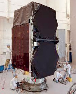
Artistic rendition of the GEO-1K 1 satellite. Image courtesy of Interfax.com
Meanwhile, CTA had been contracted to build a satellite for the Volunteers In Technical Assistance (VITA). The resulting satellite carried a transponder to test the systems and applications for GEMnet. Known as GEMStar-1, the satellite was launched on August 15, 1995, but failed to reach orbit due to the failure of the first stage of the LLV launch vehicle. The 127kg satellite was to have been placed in a 500km polar orbit.
Following this failure, the association between CTA and VITA came to an end and CTA Commercial Systems was acquired by Orbital and the GEMnet system was canceled. VITA continued its efforts and was involved in the development of the Faisat system and eventually leased bandwidth on the HealthSat-2 and UoSat-12 satellites.
Starsys
The Starsys system, proposed by the company of the same name, was to provide ultra low-cost two-way communications and positioning determination capabilities using a constellation of 24 satellites operating at 137/148MHz. The system, operating in six orbital planes, was to be operational by 1997, but by that time, the license had been surrendered. In 1998, Starsys was purchased by GE Americom who proposed a similar constellation but one that did not materialize. The name Starnet was also associated with that proposal.
Elekon
Russia, in cooperation with Germany, considered a seven satellite LEO constellation that was to be a combined communications-navigation system. The project was seeded in 1993 by a team comprised of Science and Technology International of Russia (STIR) and Elbe Space and Technology of Dresden, Germany. Named the Elekon system, the payload would consist of L-, S-, and C-band transponders. The 900kg satellites would have been in an orbit at an altitude of 1150km.
Part of the Elekon payload was tested on the GEO-IK 1 satellite that had been launched on November 29, 1994. The first operational satellite would have been launched in 1995 and full operations were expected by 1997.
IRIS
Belgium operator SAIT Systems, with the support of the European Space Agency (ESA) to meet the Agency’s Little LEO Messaging System (LLMS) requirement, advanced the Intercontinental Retrieval of Information via Satellite (IRIS) system for a world-wide electronic mail and data service using advanced communications technology. Other European concerns were also involved in the development. The system was to be operational by late 1998. The intended orbit was to be 835km with an inclination of 98.7 degrees and the number of satellites was to be dependent upon customer demand. On July 10, 1998, a LLMS payload was placed in orbit on the Russian Resurs O-2 satellite.
Leostar
Leostar was a proposed Italian mobile communications satellite system consisting of 40 satellites located in five different orbital planes and was anticipated to be operational by 1997/98—however, the proposal was not furthered.
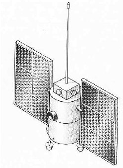
The Koskon LEO satellite.
Koskon
Koskon was a low-Earth orbit communications satellite system proposed by Russian concerns Polyet and Elas. The constellation would have consisted of 32 to 45 satellites in a 960 x 1010km orbit with an inclination of 83 degrees. The 600kg satellites were to be launched in groups of three using a Zenit 3 launch vehicle. The first satellite in the system, Informator-1, was launched on January 29, 1991. No further launches were conducted.
Kuryer
Kuryer was a constellation proposed by the Russian Elas concern and would have involved 8 to 12 satellites in a 700km orbit with an inclination of 76 degrees. The 500kg satellites would have operated in the 430-470MHz range and were to be launched by the Start 1 launch vehicle.
SPS Sputnik
Proposed by Makayev, a Russian concern, the SPS Sputnik was to provide voice, digital and fax communication services from a 510km orbit with an inclination of 70 degrees—32 to 48 satellites with a mass of 300kg each were to be launched by Shitl N1 launch vehicles from 1995.
WEST
Mata Marconi, a French company, proposed the Wideband European Satellite Telecommunication (WEST) constellation, to consist of nine satellites in MEO and two satellites in a geostationary orbit. The satellites would be based on the Eurostar 3000 platform and would use the Ka-band, with services expected to start in 2001 for Europe and neighboring areas and to then extend to other parts of the world by 2003.
KITComm
KITComm, a subsidiary of the Australian firm Kennett International Technology, proposed the use of eight or nine microsatellites for commercial security monitoring services. The satellites, which would be in a 1000km orbit, would interrogate ground based surveillance devices.
A contract for the launch of the first two satellites was placed with the US firm PacAstro, which would use its PA2 rocket to place the 230kg satellites in orbit. It is believed the first satellite was planned for launch in December of 1993, although the press release was not clear as to the status of the PA2 rocket or the launch site to be used. Eventually, launches were to take place from Darwin, Australia.

The proposal was not acted upon. Later the company considered a 21 satellite constellation with an altitude of 2800km and an inclination of 90 degrees and a mass of 3kg and fitted with L-band equipment. The first launch was envisaged for 1999.
About the author
Jos Heyman is the Managing Director of Tiros Space Information, a Western Australian consultancy specializing in the dissemination of information on the scientific exploration and commercial application of space for use by educational as well as commercial organizations. An accountant by profession, Jos is the editor of the TSI News Bulletin (http://tiros.zarya.info/) and is also a regular contributor to the British Interplanetary Society’s Spaceflight journal. Jos is also a Senior Contributor for SatMagazine.