
On October 23, 2015, at approximately 3:15 p.m., an employee for the Southern California Gas Company was conducting a twice-daily, well observation and reported the smell of natural gas around the “Standard Sensor 25” well pad at the company’s Aliso Canyon underground gas storage facility.

Orbital Sidekick’s Aurora hyperspectral satellite sensor.
Shortly following the report, a gas leak was identified. Nearly four months passed from this initial discovery to its final closure and, that time, approximately 100,000 tons of methane had escaped into the atmosphere1.
For comparison, this leak alone equates to roughly one quarter of the annual methane release across the entire Southern California basin and the long-term, environmental impact was estimated to rival that of the Deepwater Horizon oil spill2. Consequently, residents of the nearby Porter Ranch community suffered short- and long-term health effects, and many were forced to relocate3.

As of this writing, the cost to Southern California Gas from resulting lawsuits reached $1.8 billion4 — and that amount does not include the significant, direct costs for containment, clean-up and remediation.
Methane Detection: A Brief Overview
Since the first methane detection capabilities from space were realized using the European Space Agency’s SCIAMACHY sensor during 2003-2009, satellite teams have retrospectively looked back at their own data in search of evidence of methane’s unique spectral signature. Those satellites, which possess the best spectral capability for detecting the gas, typically have a spatial resolution that is not sufficient enough to pinpoint release sources.
That said,the sensors with larger spatial resolutions better enable repeated coverage on a more frequent timescale. Therefore, in recent years, teams operating the more persistent satellites have subsequently attempted to engage less-persistent but higher spatial resolution satellites — or with aerial sensors — in order to identify any leaky culprits5. Today however, technology gains are driving a significant improvement in the capability of a single satellite to persistently detect, isolate, and repair methane vapor releases.
Methane (CH4) is an odorless, colorless gas produced and emitted by a multitude of natural and anthropogenic processes. It should be noted that the “natural gas scent” often associated with natural gas or methane emissions, as was the case at the Aliso Canyon facility, is a chemical called mercaptan, or methanethiol, which is an odorizer added to enable common leak detection by smell.
Methane comprises 70-90% of the composition of produced natural gas, and a significantly higher mole % system-wide. Methane is also a trace constituent of the atmosphere (much less than 1% by volume), and accounts for a fraction of anthropomorphic greenhouse gas (GHG) emissions. Volumetrically, only 10% of these GHG emissions are methane, while carbon dioxide (CO2) accounts for closer to 80%.
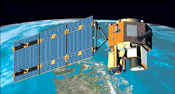
Artistic rendition of the EO-1 satellite on-orbit.
Ambient methane molecules also have a relatively short lifetime, typically decomposing after an atmospheric residence of about 12 years, compared to an indefinite period for CO2. Nevertheless, the CH4 molecule absorbs about 80 times as much heat as carbon dioxide for equivalent masses in the atmosphere, ranking it among the most important greenhouse gases6.
Considering that 50-65% of all CH4 emitted to the atmosphere comes from anthropogenic sources, and that mitigation efforts can often be mechanically implemented (whether repairing failed equipment or igniting controlled releases), many consider methane to be a “low-hanging fruit” in the effort to reduce GHG emissions. Thus, the major challenge in reducing methane releases lies in identification of those primary sources.
Currently, methane storage and by-product production facilities monitor for escaping gas using specialized equipment, either by regular employee visits and/or aerial surveys (plane/drone7). These monitoring activities can be costly and time consuming, and they are often impracticable for routine monitoring of remote infrastructure such as long distance pipelines.
However, advances in satellite technology are enabling a revolution in methane detection and monitoring. While not intentionally designed for natural gas detection, the U.S. Geological Survey (USGS) EO-1 spacecraft Hyperion imaging spectrometer detected Aliso’s Geological Survey (USGS) EO-1 space super emission on January 1st, 2016.
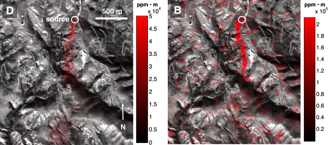
Figure 1. Comparison of airborne AVIRIS-C imagery of the Aliso Canyon emission and Hyperion imagery of the same location. (Thompson et al, 2016).
The Hyperion detection was quickly corroborated by an AVIRIS-C airborne detection on January 12th of that same year (see a comparison in Figure 1 above)8. This detection by Hyperion is seminal for the spaceborne natural gas detection community and offers a baseline for what is possible.
Figure 1: As methane is orders of magnitude lower in concentration than carbon dioxide in the Earth’s atmosphere, natural gas “hot spots” are comparatively easier to isolate from background averages using proper instrumentation. Methane has characteristic absorption features in the infrared region of the electromagnetic spectrum, which is outside of the visible range for human eyes but within range for many imaging spectrometers. It was this specific absorption feature that enabled detection by Hyperion and AVIRIS9.
Detection In Modern Times
Hyperion was decommissioned in March of 2017 and AVIRIS as an aerial platform is incapable of frequent or large-extent monitoring, owing to the inherently high cost of operation and narrow swath width. With numerous new entrants into the satellite marketplace, this persistent, targeted monitoring gap will be filled in late 2022 through the deployment of Orbital Sidekick’s (OSK) forthcoming GHOSt (Global Hyperspectral Observation Satellite) constellation. These assets will be ideal for frequent methane monitoring, alongside the broader anomaly detection capabilities of these satellites for other features.
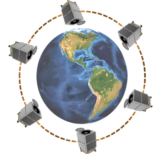
Artistic rendition of Orbital Sidekick’s GHOSt constellation.
Figure 1. Comparison of airborne AVIRIS-C imagery of the Aliso Canyon emission and Hyperion imagery of the same location. ( Thompson et al, 2016). Artistic rendition of Orbital Sidekick’s GHOSt constellation.
GHOSt will provide a comparable spectral range (400-2500 nm) and resolution (4.2nm) to Hyperion and AVIRIS and will be aided by an additional panchromatic camera for ascertaining the context of observations. In addition to the methane detection capabilities provided by GHOSt, its hyperspectral sensors offer fine spatial resolution (~8 m/pixel) and an integrated panchromatic camera (3 m/pixel). These features, when combined with a frequent targeted revisit rate (as often as daily with 6 satellites by early 2023), make GHOSt optimal for not only pinpointing the sources of methane emissions, but doing so in a rapid and persistent manner.
Innovations in image processing technology and data analytics further allow OSK to implement automated detection and reporting from space, which significantly reduces the need for human operators on the ground or in the air. This equates to shorter processing time, lower cost, and more efficient monitoring.

Methane mapping and monitoring is just one of the many applications being offered by OSK — other uses for the company’s data capture, analysis, and reporting capabilities include oil spill detection, vegetation health monitoring, right of way intrusion detection, and mineral identification. OSK’s six-satellite constellation with mid-range, spatial resolution can accomplish frequent monitoring and precise correlation to sources on the ground.
For several decades, and certainly since the early 1980s, the promise of satellite-based hyperspectral imaging and analysis to ‘see the unseen,’ has captured the imagination of countless scientists and engineers. This promise has proved elusive due to the unavailability and cost of data, combined with the impracticality of conducting rapid analysis and reporting to enable timely response. Today, this is changing as Orbital Sidekick begins delivering actionable insights to operators on methane emissions and other leaks and threats to their assets.
www.orbitalsidekick.com
References
1 https://www.cpuc.ca.gov/regulatory-services/safety/pipeline-safety/aliso-canyon-well-failure
2 https://www.independent.co.uk/news/world/americas/california-methane-gas-leak-more- damaging-than-deepwater-horizon-disaster-a6794251.html
3 https://www.kcrw.com/news/shows/greater-la/porter-ranch-health-toxins-coronavirus- art/aliso-canyon-gas-leak-residents-sick-5-years-later#:~:text=After%20the%20 blowout%2C%20the%20Los,no%20long%2Dterm%20health%20risks
4 “Southern California Gas Co. settles lawsuit alleging Prop. 65 violations in 2015 gas leak”, LA Times, Feb 3, 2022; https://www.latimes.com/california/story/2022-02-03/so-cal-gas- settles-lawsuit-alleging-prop-65-violations-in-2015-gas-leak
5 https://agupubs.onlinelibrary.wiley.com/doi/full/10.1029/2019GL083798
6 https://www.epa.gov/ghgemissions/overview-greenhouse-gases
7 https://pubs.acs.org/doi/10.1021/acscentsci.7b00292
8 Thompson, D. R., A. K. Thorpe, C. Frankenberg, R. O. Green, R. Duren, L. Guanter, A. Hollstein, E. Middleton, L. Ong, S. Ungar (2016), Space-based remote imaging spectroscopy of the Aliso Canyon CH4 superemitter, Geophysical Research Letters, 43(12), 6571–6578.
9 Thompson, D. R., A. K. Thorpe, C. Frankenberg, R. O. Green, R. Duren, L. Guanter, A. Hollstein, E. Middleton, L. Ong, S. Ungar (2016), Space-based remote imaging spectroscopy of the Aliso Canyon CH4 superemitter, Geophysical Research Letters, 43(12), 6571–6578.