
Untapped Opportunities In Earth Observation (EO)

Falling launch costs and less expensive satellites are providing a deluge of EO data.
ASTERRA’s James Perry, discusses how downstream companies are adapting their business models to take advantage of this abundance of near real-time, low-resolution imagery.
According to the Union of Concerned Scientists, as of January 1st 2022, there were 4,852 satellites orbiting Earth, of which 1,030 satellites are wholly, or partially, geared toward EO. As well as satellites being increasingly numerous, they are also increasingly likely to be small; even excluding large constellations, smallsats — those weighing less than 600 kg. — launched in 2021 was the highest number during the last 10 years. Smallsats are less expensive to produce than ever before and, combined with falling launch prices, this means it is easier today for companies to launch their sensing hardware into space.

This growth in the number of small EO satellites is creating a wave of new data, tearing down the barriers to entry for downstream data analysis companies and bringing satellite imagery ever closer to real-time. This increased accessibility to near, real-time imagery from increasingly specialized satellites is opening new markets that rely on regular, reliable and almost live data.
One such market created by EO data is monitoring critical infrastructure. Take water, for example. Traditionally, leaking water pipes — which waste billions of gallons of drinkable water each day — would be located by crews from water companies that are manually inspecting miles of pipes each day. ASTERRA adapted analytics first used to find water on Mars to detect subsurface leaks from water networks here on Earth using commercially available satellite Synthetic Aperture Radar (SAR) imagery. As SAR data becomes available at higher cadences, ASTERRA can provide more information at a higher resolution and increasingly offer close to real-time insights to customers.
ASTERRA has shown that it can take commercially available EO data and sell it as actionable insights. This approach isn’t limited to providing game-changing information to managers in the water industry. ASTERRA’s EarthWorks product applies the same technology used to detect leaking pipes to monitoring infrastructure in the mining industry, as well as roads, railways, and dams.
Subterranean water is the bane of engineered projects and tracking soil moisture content can help critical infrastructure remain healthy, safe and usable for decades. ASTERRA modeling and analysis provides a preview of damage before it occurs and allows customers modeling and analysis provides a preview of damage befor direct, preventive maintenance to where it is most needed.
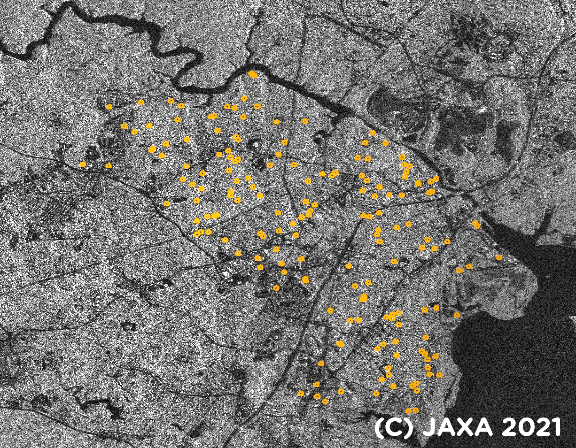
An ALOS-2 SAR image overlaid with ASTERRA Recover — likely leak
locations depicted in yellow
This proactive approach to managing infrastructure is but one example of the various sustainability benefits of satellite imagery. As sustainable development becomes increasingly crucial to companies and consumers, the insights that downstream companies can extract from satellite imagery will become increasingly valuable. Satellite imagery can help monitor emissions, make more efficient use of resources and drive smarter business decisions; downstream companies are emerging with sustainability at the forefront of their business models.
As well as being a good example of driving sustainability from space, ASTERRA’s use of satellite imagery exemplifies another wider trend in the market: generating actionable insights by combining archival imagery, ongoing monitoring, and additional layers of information. One of the benefits of satellite imagery is that reliable historical observations can be combined with other information — things such as seasonality or knowledge of catastrophic events. This can provide a good planning tool for commercial projects or can help communities recover from natural disasters. To take one example, insurance providers can use a combination of satellite imagery and ground reports to determine the impact of catastrophic events on their customers and are able to respond much more quickly than they would otherwise be able to accomplish.
Another trend transforming the downstream sector is satellite imagery increasingly being integrated into other sources of information, such as expensive ground sensors that are augmented by large-swath satellite imagery. This approach has well-established precedents — such as weather forecasts relying on detailed weather station measurements and large- scale satellite images — and will expand the customer base for satellite imagery.
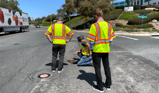
A local team checking on an identified water leak.
The growth in innovative applications for commercial satellite imagery is underpinned by greater numbers of satellites generating greater amounts of data as well as better infrastructures for accessing and disseminating this data. Rather than obtaining imagery by tasking satellites to observe specific regions, downstream companies will increasingly be able to adopt a Software-as-a-Service (SaaS) approach and provide analytics built on a huge repository of commercially available, near real-time satellite imagery.
The expanding EO marketplace is going to provide unique, unprecedented applications in the commercial and consumer sectors. It doesn’t matter how small or how big a company may be, there are opportunities for visionaries, startups or existing firms to come in with fresh ideas and capture a share of the market — particularly with the seed funding available from venture capitalists. Established well-funded players in the downstream sector are also increasingly collaborating with small start-ups to develop applications for new sectors and untapped markets.

There are other factors set to shape the EO market, including addressing regulatory compliance and increasing awareness of sustainability but there is still tremendous energy in the emerging downstream business ecosystem. The groundwork is being laid for transformative change — close to real-time satellite imagery is going to change the world in ways that we cannot even begin to anticipate.
asterra.io

James Perry
James Perry is the Executive Vice President of ASTERRA and he has demonstrable history of working in the computer software industry. He is highly skilled in Business Planning, Go-to-market Strategy, Strategic Partnerships, Management, and Solution Selling and possesses strong business development expertise. Mr. Perry graduated from United States International University.