
Innovative approaches to space-based RF data collection
With the launch of Pathfinder in 2018, HawkEye 360 became the first commercial company to use a cluster of smallsats in Low-Earth-Orbit (LEO) to detect, geolocate and characterize a broad range of RF signals.

The mission of being the world’s leading technology provider of space-based radio frequency (RF) data and analytics is only achieved by deploying an ever- evolving satellite constellation and continuously expanding ground-processing capabilities. Striking the proper balance between rapid innovation and a dedication to quality is key to providing the insights valued by our customers.
HawkEye 360 has successfully geolocated more than 200 million RF signals, offering situational awareness across a diverse range of activities. Space- based RF provides the ability to detect and monitor illicit and unintentional activities around the world, such as detecting GPS interference, illegal fishing, and illegal mining, and enhancing the efficiency of land and maritime surveillance operations.

The company’s distinctive ability to commercially identify and geolocate sources of radio frequencies from space, combined with streamlined data analysis processes, provides a highly valuable and cost-effective resource to unveil previously hidden insights into activities worldwide. This comprehensive understanding ultimately contributes to making the world a safer place to live.
Over the past four years, HawkEye 360 has focused on enhancing capacity, reducing revisit times, and increasing ground-processing capabilities to improve analytics. To achieve this, HawkEye 360 has a vision for building a satellite constellation consisting of 20 clusters, with each cluster comprising three satellites.
This constellation will feed data into ground terminals that move data back to a highly scalable, cloud-based, ground system. The clusters will be deployed in various sun-synchronous and mid-inclination orbits to achieve optimal global coverage. Currently, HawkEye 360 operates 21 satellites (7 clusters) out of the planned 60 satellite constellation. The company is on schedule to launch two additional clusters into a mid-inclination orbit at an altitude of 530 km in late 2023 using a RocketLab Electron rocket from New Zealand.
HawkEye-360 has strengthened its satellite manufacturing capabilities by establishing an in-house manufacturing facility. This facility, equipped with a clean room and electronics lab, has significantly improved the efficiency of testing, integration, and assembly processes.
The inaugural satellite built at the Herndon facility, Cluster-7, was successfully launched earlier this year aboard Transporter-7 and underwent a swift checkout process and achieved formation initialization in the shortest amount of time, yet achieved here at HawkEye 360. Currently, efforts are underway to expand the facility to include additional environmental testing capabilities, which will further accelerate the satellite production timeline.
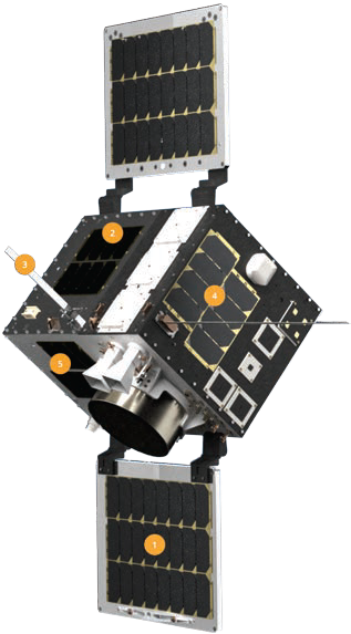
Legend
1 - Tremendous collection capability in a small size
2 - Powerful on-board computing
3 - Simultaneous collects
4 - Improved latency, frequency revisits
5 - Signal trilateration
By decreasing the production timeline, HawkEye 360 will be able to scale the constellation faster and provide continuously improving on-orbit capabilities to support their customer’s missions. With each launch, HawkEye 360 continues to extend frequency ranges and deliver streamlined data critical to their customer’s decision-making process.
“Providing RF collection capability across many frequencies on a small satellite was an ambitious goal from the beginning,” explained Eric Haengel, Director of Space Systems at HawkEye 360. “While earlier spacecraft designs made
significant progress, there were still frequency gaps in our coverage. However, through incremental improvements implemented across different clusters, we have successfully filled those gaps. I’m proud to say that the latest spacecraft design now boasts the capability to cover the entire frequency range. It’s a testament to our ongoing dedication to advancing our RF sensing capabilities.”
HawkEye 360’s space team embraces the smallsat principle of continuous innovation. Notable advancements are incrementally introduced with each new cluster launched as part of the Block-2 series of satellites. In this way, we can rely on well-proven, TRL-9 legacy designs but also incorporate new technologies for demonstration and to enhance system capabilities.

For example, adding specialized antennas has expanded range over more and more frequencies. Enhancements to the payload have improved collection flexibility, system-level redundancies, and the amount of data we can manage.
Throughout these developments, HawkEye 360 engineers remain dedicated to achieving rapid innovation without compromising reliability. The space team can deploy new hardware to orbit while maintaining the data quality customers have come to expect, making it possible to tackle a growing number of customer needs.
As constellations expand in size, it is crucial to prioritize reliability and innovation for the space-based assets as well as for the ground infrastructure. Extensive development efforts are required to ensure the seamless retrieval, processing, and delivery of data to customers in a timely manner.
HawkEye 360 has established a robust ground infrastructure consisting of multiple antennas at six partner locations to operate the company’s satellites effectively. This setup allows for multiple downlinks per orbit, significantly reducing latency. Data from the ground sites is then piped back to a cloud- based processing infrastructure — this approach was key for allowing the ground compute requirements to scale seamlessly with the constellation.
HawkEye 360 has been making significant progress in enhancing ground processing capabilities, alongside increasing capacity in space. These improvements enable the efficient handling of a larger volume of data received from satellites.

Despite the substantial increase in data, the company ensures that data products are delivered with minimal delay. Moreover, HawkEye 360 is expanding its analytics capabilities for geolocation, enabling more detailed information to be extracted from RF emissions.
This expansion allows customers to access a wider range of devices through the RFGeo product. Additionally, the company has made significant investments in using artificial intelligence and machine learning (AI/ML). This integration allows customers to gain deeper insights automatically from the RF data.
HawkEye 360 uses AI/ML modeling techniques to associate their data with automatic identification systems (AIS) datasets. This enables analysts to swiftly identify geolocations that could be linked to suspicious maritime vessels. Moreover, early research has expanded these algorithms to connect HawkEye 360 data with maritime vessels identified in imagery.
The application of AI/ML has also proven effective in extracting distinctive features from raw RF waveforms, aiding HawkEye 360’s research on unique signal recognition (USR). These advancements have significantly enhanced their capabilities in identifying and characterizing devices.
As HawkEye 360 looks ahead, the firm is actively investigating how to strike a balance between innovation and reliability in the design of the Block-3 satellites. The evolving demands of their customers have shifted the focus from capacity and revisit times to one of reduced latency. Some customers now require near real-time actionable data and that represents a fundamental departure from the store-and-forward approach of the Block-2 satellites.
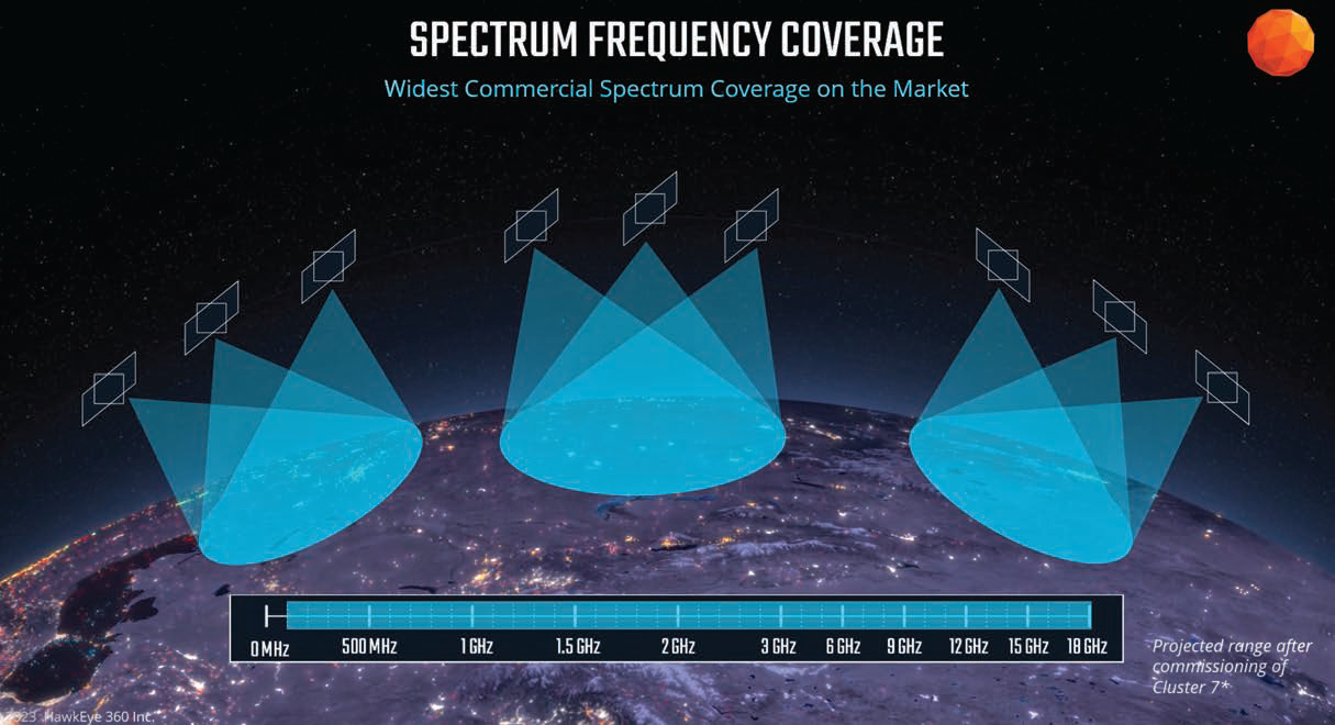
HawkEye 360’s satellite constellation: Clusters of three, geolocating global RF signals with unprecedented reach, boasting the market’s widest commercial spectrum coverage and an impressive 1,000,000 sq km footprint per pass.
Although the specific details of how this shift will manifest in the design of the Block-3 satellites have not been announced yet, HawkEye 360 remains committed to maintaining a delicate equilibrium between innovation and reliability. The firm understands the importance of incorporating advancements while ensuring that the system’s reliability and dependability are not compromised. By finding this equilibrium, HawkEye 360 will continue to meet the changing needs of its customers in an ever-evolving landscape.
HawkEye 360’s work with the U.S. government and allied governments around the world is critical to fostering a safer and more secure world, including in the Middle East and Indo-Pacific regions.
HawkEye 360 has partnered with the NRO’s Commercial Systems Program Office to assess, mature, integrate, and operationalize commercial RF intelligence to support warfighters, the intelligence community, and policymakers. In both the civil and military domains, RF intelligence plays a critical role in our everyday lives.
This expansion allows customers to access a wider range of devices through the RFGeo product. Additionally, the company has made significant investments in using artificial intelligence and machine learning (AI/ML). This integration allows customers to gain deeper insights automatically from the RF data.
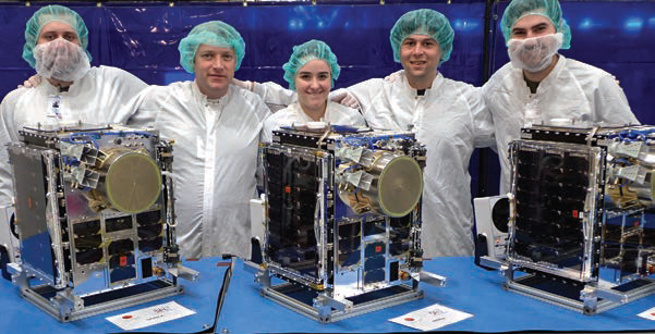 The HawkEye 360 team proudly presents their Cluster 7 satellites, advancing frequency range, revisit rates, and data delivery speed with every launch - each satellite is meticulously designed and tested in their Advanced Technology Center.
HawkEye 360 uses AI/ML modeling techniques to associate their data with automatic identification systems (AIS) datasets. This enables analysts to swiftly identify geolocations that could be linked to suspicious maritime vessels. Moreover, early research has expanded these algorithms to connect HawkEye 360 data with maritime vessels identified in imagery.
The application of AI/ML has also proven effective in extracting distinctive features from raw RF waveforms, aiding HawkEye 360’s research on unique signal recognition (USR). These advancements have significantly enhanced their capabilities in identifying and characterizing devices.
As HawkEye 360 looks ahead, the firm is actively investigating how to strike a balance between innovation and reliability in the design of the Block-3 satellites. The evolving demands of their customers have shifted the focus from capacity and revisit times to one of reduced latency. Some customers now require near real-time actionable data and that represents a fundamental departure from the store-and-forward approach of the Block-2 satellites.
Although the specific details of how this shift will manifest in the design of the Block-3 satellites have not been announced yet, HawkEye 360 remains committed to maintaining a delicate equilibrium between innovation and reliability. The firm understands the importance of incorporating advancements while ensuring that the system’s reliability and dependability are not compromised. By finding this equilibrium, HawkEye 360 will continue to meet the changing needs of its customers in an ever-evolving landscape.
HawkEye 360’s work with the U.S. government and allied governments around the world is critical to fostering a safer and more secure world, including in the Middle East and Indo-Pacific regions.
HawkEye 360 has partnered with the NRO’s Commercial Systems Program Office to assess, mature, integrate, and operationalize commercial RF intelligence to support warfighters, the intelligence community, and policymakers. In both the civil and military domains, RF intelligence plays a critical role in our everyday lives.

Satellite RF intelligence exposes patterns of life and previously undetected activity to provide a new layer of insight that both commercial and government partners leverage to make timely, effective decisions.
Through HawkEye 360’s technical capabilities, defense leaders can rest assured that provided data will deliver an advantage in executing a strategy that counters threats and efficiently achieves the mission.
www.he360.com

Glenn Richardson, the Senior Director of Space Coordination at HawkEye-360, heads a team that specializes in systems engineering and Tier-3 satellite operations. With nearly 25 years of experience, Glenn has been extensively involved in the design, construction, programming, launch, and operation of RF-sensing small satellites. His expertise and knowledge in this field contribute significantly to HawkEye-360’s satellite operations and overall mission success.

Kate Zimmerman, HawkEye 360’s first-ever, Chief Data Scientist, develops the company’s analytics strategies and enhancements to grow its RF data analysis capabilities while harnessing the power of artificial intelligence to enable the public sector, commercial, and humanitarian customers to create a better world.
HawkEye 360 is a defense technology leader providing ubiquitous knowledge of human activity, behavior, and situational trends derived from revolutionary radio frequency (RF) geospatial intelligence. The company’s innovative space-based technology was developed to detect, characterize, and geolocate a broad range of RF signals. These RF data and analytics provide an information advantage allowing analysts to detect the first glimpse of suspicious behavior, trace the first sign of hostile activities, and reveal the first sighting of ships attempting to vanish. HawkEye 360’s RF intelligence presents a quicker grasp of critical events and patterns of life, providing early warnings to drive tip-and-cue efforts, and providing global leaders the insights needed to make decisions with confidence. HawkEye 360 is headquartered in Herndon, Virginia.