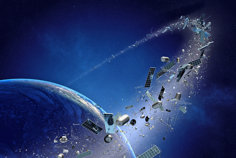
The space environment has changed drastically over recent years, with ever more satellites being launched at an astounding pace. This is, of course, leading to an ever more congested space environment and an increase in close approaches.

The Space Data Center was developed to be able to make the space environment safer, warning operators of close approaches. It is having a great effect and has alerted operators to many potential collisions. However, with the skies getting more crowded, there is a growing need for even more accurate data and operational actionable information.
The Risk of Collision
The risk of collision is always at the forefront of all satellite operators’ minds and it is something that we invest heavily in to avoid. Of course, it is not just about avoiding collisions in your own fleet, as any collision could have a catastrophic result for all of us. As well as causing yet more debris that itself can cause damage to other satellites, any collisions would likely result in profound political, business, legal, and practical consequences which would impact our ability to access this precious resource. In the worst case, they could even deny its use by future generations.
The Space Data Association (SDA) is focused on improving space situational awareness for the entire industry and is therefore constantly evaluating and re-evaluating the environment, the tools in place, and the risks to all those operating in space.
Recently, we have undertaken extensive analysis into these factors and the operators that make up the SDA collectively concluded that the collision risks are increasing and are higher than previously understood. Following this analysis, it was clear that something needed to be done to improve the accuracy of the data and hence reduce the risk for us all.
Improving Accuracy
Current systems are in place to track satellites and debris. However, tracking small enough objects at high accuracy has historically been a challenge.
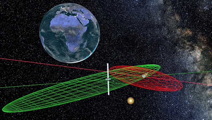
The problem is that orbital debris as small as 20 cm in size can cause catastrophic, debris-generating collisions. This will, of course, make the environment yet more crowded and increase risk of further collisions. Current services track objects down to only around 1 meter in size for collision warnings in the geostationary arc. There is clearly a need for better and more sensitive observations of objects in the geostationary regime.
As well as being able to track smaller objects, it is vital we can track all debris effectively and allow the orbits to be accurately determined. Ultimately, this should lead to less frequent, but actionable, collision warnings.
That, of course, saves time and money for the operator in terms of not having to review inaccurate warnings and also makes the space environment safer by ensuring genuine collision risks are flagged in time for satellite operators to implement avoidance maneuvers.
Securing the Future
At the SDA, we have spent the past year conducting a comprehensive review to better understand the risks and mitigate them by developing a plan to cost-effectively acquire independent, transparently-derived, high-quality information to provide actionable safety of flight services.
Having undergone a comprehensive process to determine key requirements, conduct extensive market research, and following a competitive procurement process, we have entered into an agreement with Analytical Graphics Inc (AGI) to build an updated version of the Space Data Center, SDC 2.0.
SDC 2.0 has a highly accurate, independently generated, catalog of space objects which will grow to include objects larger than 20 cm in and traversing the geostationary arc. This catalog will allow for transparent and actionable collision warnings, enabling the operator to know what action is going to be required.
The service also features functionality to combat Radio Frequency Interference (RFI), including the construction of geolocation scenarios and a Carrier ID database. This will be vital to reducing the impact of interference, something which causes considerable problems for our industry, costing operators valuable time and money on a daily basis.
A Collaborative Approach
In the UK, at least, it is often the case that safety measures are only introduced after a serious accident occurs. Currently, we have the opportunity to act before a major collision occurs in the geostationary arc, but we need the entire industry to be working together to mitigate these risks.
SDC 2.0 is a major step forward in allowing potential collisions to be timely identified, thereby reducing the risk for the entire industry. The more operators that sign up for this important and informative catalog, the more satellites will be protected and the risk lowered of something going wrong.
space-data.org/sda/