
First Partner For Thuraya’s North American M2M Service Is Named... X2nSat

Global satellite communications solutions provider X2nSat is partnering with Thuraya Telecommunications Company to offer an innovative, new, M2M service in North America.
Thuraya announced in March the launch of their M2M service and FT2225 terminal.

The gap in the market between the current ‘store and forward’ and IP broadband services will now be addressed by the X2nSat solution, according to the CEO of the company, Garrett C. Hill.
“X2nSat will offer the new Thuraya FT2225 fixed terminal, which offers exceptionally efficient bandwidth usage, low latency IP networking and high levels of security. The FT2225 always on connectivity enables real time monitoring and control to support applications in the government, utilities, remote banking, O&G and mining sectors,” he said.
Bilal El Hamoui, Chief Commercial Officer at Thuraya, is extremely confident of this partnership and that this agreement will further enhance the company’s commitment to provide end users with the best solutions, no matter where they are located across the globe. Additionally, he added that the launch of this new service will address the M2M / IoT market Working in partnership with X2nSat, Thuraya will now be able to further extend its reach into US markets.
The gap in the market between the current ‘store and forward’ and IP broadband services will now be addressed by the X2nSat solution, according to the CEO of the company, Garrett C. Hill.
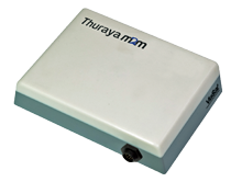
Thuraya’s FT2225 terminal.
“X2nSat will offer the new Thuraya FT2225 fixed terminal, which offers exceptionally efficient bandwidth usage, low latency IP networking and high levels of security. The FT2225 always on connectivity enables real time monitoring and control to support applications in the government, utilities, remote banking, O&G and mining sectors,” he said.
Bilal El Hamoui, Chief Commercial Officer at Thuraya, is extremely confident of this partnership and that this agreement will further enhance the company’s commitment to provide end users with the best solutions, no matter where they are located across the globe. Additionally, he added that the launch of this new service will address the M2M / IoT market that requires a highly efficient, low latency, IP network.
www.x2nsat.com
www.thuraya.com
Outerlink Global Solutions Obtains FAA STC Okay For IRIS
Outerlink Global Solutions now has FAA STC approval of the company’s fully integrated IRIS voice, video, flight data and broadband SATCOM system in the Bell model 206L and 407 series helicopters—the IRIS solution promotes safer operations as well as delivers immediate cost savings and reduced downtime.
IRIS combines multiple features currently available from various vendors into one single solution at a fraction of the cost that an operator would pay for each of the components it replaces. The two onboard boxes, a control head and processor provide continuous aircraft and internal data, audio and video recording. The system can record up to 1,000 hours of data received from over 200 sources, depending on model type, giving the operator unprecedented insight into the operation of the aircraft. The system also includes internal, always-on wireless connectivity for electronic flight bags (“EFB’s”) or for continuous data downloads.
With an open architecture and push-to-talk solution, IRIS gives operators the latest communication technology with just one installation. From the ground, crews can monitor aircraft data and receive immediate alerts and warnings when an aircraft exceeds a defined parameter. In addition, pilots and crew can communicate via talk groups using push-to-talk technology.
The software suite accompanying IRIS provides the only integrated time-synced playback of audio, video and flight data, giving operators insight into how their fleet is being flown. Due to its software-based configuration, IRIS is protected against obsolescence. If satellite providers come up with faster service in other bands, IRIS users can adapt by simply changing their antennas. The adaptability is another cost saving factor for operators to consider when choosing a communication and data-monitoring tool.
IRIS is compatible with a full range of aircraft, from older analog models to the newest on the market. Even with a mixed fleet, IRIS provides an integrated monitoring and communications system for operators. In addition, IRIS meets all aspects of the FAA 135.607 ruling.
outerlink.com/?q=IRIS
ETL Systems To Showcase New Technologies At CommunicAsia2016

ETL Systems will be showcasing their new RF distribution technologies at this year’s CommunicAsia in Singapore.
ETL will be exhibiting the smallest matrix of its kind on the market. The new 64 x 64 Hurricane boasts inclusive LNB powering in a 4U compact, modular chassis.
Hurricane’s flexible design offers optimized performance and a range of customizable options to suit a particular set of RF needs, such as fiber inputs, variable gain and variable slope which can be individual to each feed.
ETL has also designed new functionality and increased benefits into a series of advanced products.
These new features may be found in the firm’s StingRay RF over Fiber and Dextra splitters and combiners.

ETL Systems Dextra splitter front panel.
New StingRay models on display at the show will include redundancy systems for reliability and standalone component modules.
ew Dextra models now include options with integrated DC & 10MHz pass.
If attending CommunicAsia2016, take the opportunity to visit the ETL Systems at Stand 1V3-03.
etlsystems.com/
India’s Seventh & Final IRNSS Satellite Launched
In its 35th flight (PSLV-C33), ISRO’s Polar Satellite Launch Vehicle successfully launched the 1425 kg IRNSS-1G, the seventh satellite in the Indian Regional Navigation Satellite System (IRNSS) on April 28, 2016, from Satish Dhawan Space Centre SHAR, Sriharikota—this is the 34th consecutively successful mission of PSLV and the thirteenth in its ‘XL’ configuration.
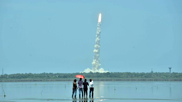
The launch of IRNSS-1G. Photo is courtesy of R Satish Babu/EPS.
After the PSLV-C33 lift-off at 1250 hrs (12:50 pm) IST from the First Launch Pad with the ignition of the first stage, the subsequent important flight events, namely, strap-on ignitions and separations, first stage separation, second stage ignition, heat-shield separation, second stage separation, third stage ignition and separation, fourth stage ignition and satellite injection, occurred as planned.
After a flight of 19 minutes 42 seconds, IRNSS-1G was injected into an elliptical orbit of 283 km X 20,718 km inclined at an angle of 17.867 degree to the equator (very close to the intended orbit) following which the satellite successfully separated from the PSLV fourth stage.
After separation, the solar panels of IRNSS-1G were deployed automatically. ISRO’s Master Control Facility (MCF) at Hassan, Karnataka took over the control of the satellite.
Over the coming days, four orbit maneuvers will be conducted from MCF to position the satellite in the Geostationary Orbit at 129.5 degrees East.

IRNSS-1G is the seventh of the seven satellites constituting the space segment of the Indian Regional Navigation Satellite System.
IRNSS-1A, 1B, 1C, ID, IE and 1F, the first six satellites of the constellation, were successfully launched by PSLV on July 02, 2013, April 04, 2014, October 16, 2014, March 28, 2015, January 20, 2016 and March 10, 2016 respectively. All the six satellites are functioning satisfactorily from their designated orbital positions.
IRNSS is an independent regional navigation satellite system designed to provide position information in the Indian region and 1500 km around the Indian mainland. IRNSS provides two types of services, namely, Standard Positioning Services (SPS)—provided to all users and Restricted Services (RS)—provided to authorized users.
A number of ground facilities responsible for satellite ranging and monitoring, generation and transmission of navigation parameters, etc., have been established in 18 locations across the country.
This successful launch of IRNSS-1G, the seventh and final member of IRNSS constellation, signifies the completion of the IRNSS constellation.
India is now one of five countries with its own navigational system, meaning the nation is free of dependence upon other countries for their navigation needs.
The name, NAVIC (Mariners), is in honor of India’s mariners and fisherman who have been navigating using the sun and the stars as waypoints for hundreds of years.
isro.gov.in/
Telesat To Obtain Two Ka-Band Satellites
Telesat has procured two prototype Ka-band satellites for operation in Low Earth Orbit (LEO) that the company anticipates launching mid-to-late 2017 as part of a test and validation phase for an advanced, global LEO satellite constellation that Telesat is developing.

Through an authorization issued by Innovation, Science and Economic Development Canada (ISED), Telesat has secured priority rights to certain Ka-band spectrum in non-geostationary orbits (NGSO) at the International Telecommunications Union (ITU) to operate such a constellation.
Telesat has contracted with Space Systems Loral (SSL) of Palo Alto, California, and Surrey Satellite Technology Limited (SSTL) for the procurement of the prototypes.
By drawing on the advanced technologies and expertise of these leading manufacturers, Telesat will test and demonstrate two distinct spacecraft in LEO, a key step in optimizing the design and performance of Telesat’s contemplated LEO constellation.
With this contract, SSL currently has 21 LEO satellites in production. SSL also has two GEO satellites in production for Telesat.
According to John Celli, the President of SSL, the prototype spacecraft SSL is providing to Telesat demonstrates the versatility of the company’s LEO capabilities, and because of the firm’s focus on low cost production, a growing range of satellite contracts are now in SSL’s “win” column.
Dave Wendling, Telesat’s Chief Technical Officer, offered the fact that the firm’s Anik F2 satellite was the first to provide Ka-band high throughput satellite capacity, and that Telesat’s global constellation development of advanced, high throughput LEO satellites, which will operate in Ka-band, will offer a number of important advantages for the global delivery of high capacity broadband services.
www.telesat.com/
www.sslmda.com/
sstl.co.uk/