Satellite-based communications systems are poised to provide a revolutionary class of service: low-cost, narrow-band, two-way, ubiquitous connectivity which is often called Satellite IoT. Affordable pricing will attract a broad new consumer base, expanding accessibility from a privileged minority to entire populations. ‘Low-cost’ in this context means total-costs-of-ownership in the range up to, say, $1/month. That is, device costs will match those of terrestrial IoT (a few dollars), and data cost will be pennies per month.
Applications abound as described in the websites of the many contenders for this technology1. Examples include industrial, government, and consumer use cases:
• Asset Tracking: vehicles, boats, planes, rolling stock, pets, farm animals
• Metering and Control: electricity, water, gas, fuel, solar panels, agriculture
• Text Messaging: vehicles, smart phones
Satellite IoT Architectures
Satellite system architectures that are vying to provide low-cost, global connectivity fall into two categories.
• LEO (Low Earth Orbit) low-cost satellites: This category centers around the use of small LEO satellites, typically Cubesats. Many companies2 are pursuing this approach, with varying configurations in terms of altitude, one-way or two-way transmission, satellite size, frequency band, and means for connecting to gateway stations.
• GEO (Geosynchronous Earth Orbit) conventional MSS (Mobile Satellite System) satellites: This category uses a class of satellites that has provided ubiquitous connectivity over several decades for applications ranging from voice calls to internet access to video transmission.
Approximately 25 companies are currently developing architectures targeting Satellite IoT. With one exception these companies use LEO, low-cost satellites.
The exception is eSAT Global. Although intuition might suggest that low-cost satellites would lead to low-cost IoT-type connectivity, the numbers tell a different story. Quantitative comparison of LEO vs. GEO performance reveals clear and possibly surprising conclusions, as summarized in the chart shown above. That is, in the key areas of cost-per-bit (in both directions), terminal transmit power, capacity, and spectral efficiency, GEO satellites offer a multiple of around 100x better performance.
While the many issues that drive these estimates vary across the range of applications and satellites, the general conclusion regarding the advantages of GEO remains consistent. This possibly counter-intuitive result arises from a combination of factors. The most significant of these relates to the ability of GEO satellites to direct power and sensitivity to relatively small areas on the Earth’s surface (despite their altitude). Typical GEO MSS spot beams are many times smaller than the beams synthesized by cubesat-class satellites, an advantage that flows to all the metrics shown in Figure 1.
The map in Figure 2 illustrates the concept, where the red LEO satellite beam is much larger than the hexagonal GEO beams. Given a fixed band of spectrum, the same satellite transmission power, and similar modulation and coding, the GEO system could provide the same data throughput in each of the hexagonal smaller beams as the LEO system could in the larger red beam.
In addition to these quantifiable advantages, the following benefits reinforce the position of GEO satellites as the better platform for IoT:
• GEO MSS satellites are already in place. Hence, new constellations of satellites don’t need to be developed, launched, and supported. Capital expenditure and development times are much lower.
• The GEO MSS spectrum is licensed and allocated, so (a) interference is managed and (b) the regulatory framework is set.
• The GEO communications channel is benign, i.e., the modest Doppler frequency shifts are easily tracked. For LEO operation, the complexity and overheads associated with high, rapidly varying Doppler are daunting, especially in the forward link (where the terminals must address the issue in their receivers). Perhaps in consideration of this challenge, several LEO systems only support one-way transmission (terminal-to-network), impacting both their communications reliability and their range of supportable applications.
• Mobility management is simpler for GEO. Handoffs typically aren’t happening every few minutes.
The continuous presence of the satellite link enables:
a. Efficient service modes, such as Scheduled Transmissions
b. Low latency, as delay is not impacted by gaps between moving LEO satellites
c. Maximized efficiency in the use of satellite resources, i.e., satellites are not idle while passing over areas on the Earth’s surface without service.
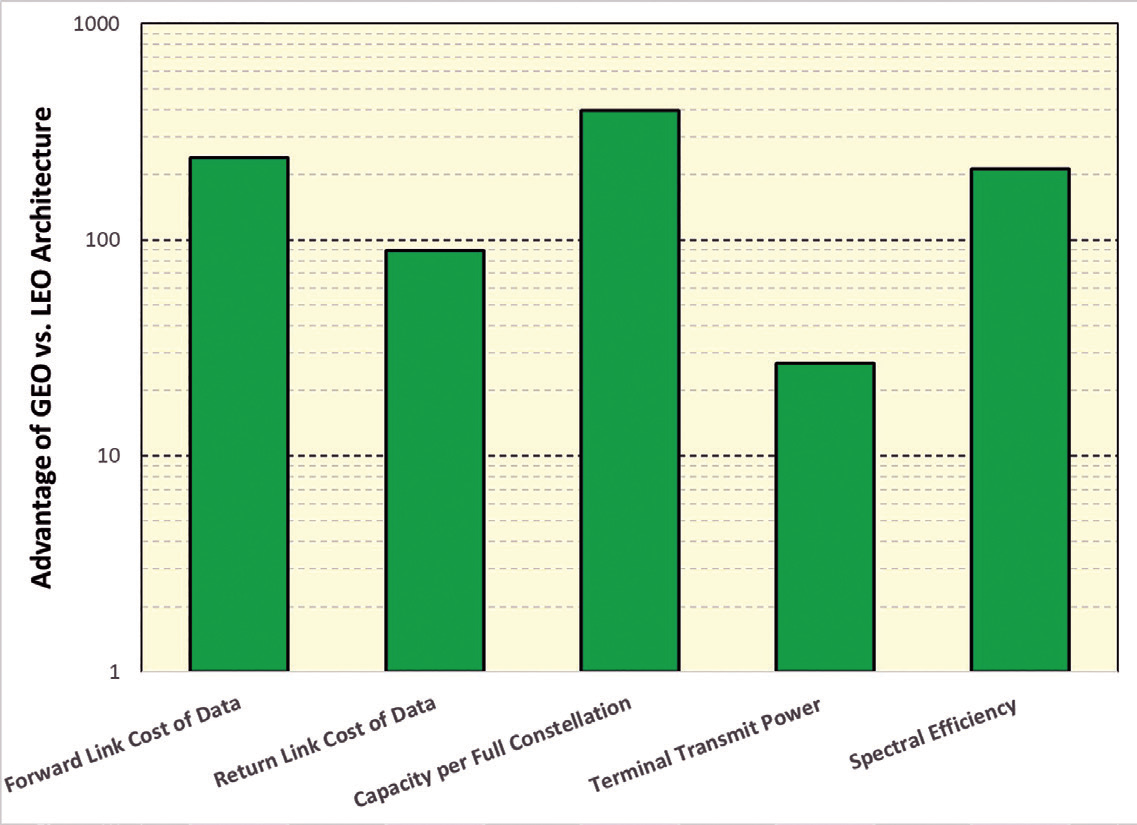 Figure 1. Comparison of LEO and GEO Metrics
GEO MSS satellite operators can integrate narrowband connectivity with legacy services, improving efficiency in use of their resources. For example, IoT status reporting could be concentrated at the times of day when legacy activity is light.
LEO systems do have at least one advantage: the potential for coverage at the Earth’s poles. With the exception of service in these areas, though, GEO satellite systems consistently provide significant advantages as a platform for Satellite IoT. A detailed report comparing the LEO and GEO alternatives is available from the author.
eSAT Global Design Drivers
The air interfaces currently used with GEO MSS satellites are poorly suited to low-cost IoT. They have high overheads when communicating small quantities of data and they require high terminal transmission power.
GEO MSS satellites are bent pipe, — this means they enable the implementation of new air interfaces. eSAT Global has developed an air interface specifically oriented to GEO MSS satellites. The central objectives are (a) to target IoT type connectivity, and (b) to do so with waveforms that can coexist efficiently with legacy air interfaces over GEO MSS satellites.
The eSAT system design is driven by the question, “What is the least-total-cost approach to communicating modest quantities of data to and from remote locations?”. Key elements of the approach can be viewed from the perspective of a terminal.
• Terminal Size, Weight, and Power (SWaP) and cost should be minimized.
• Energy per transmitted bit should be minimized, enabling longer battery life, i.e., satellite links supporting the lowest possible terminal energy-per-bit should be used.
• The cost of providing terminal sensitivity should be balanced against the cost of satellite power directed at that terminal.

Transmission bit rates vs. terminal power requirements represent a key trade-off. Bit rates should be high enough to support a broad range of applications. For example, asset tracking location reports and meter reading reports (where the number of bits may be in the range from ~100 to ~1,000 bits) would typically have acceptable latency in the order of minutes. Alarms, on the other hand, where information such as an intrusion alert (requiring, say, 10s of information bits) might be better served by delays in the order of 1-2 seconds.
A separate constraint on the minimum bit rate arises due to the physics of the links in the form of phase noise. As bit rates decrease, the period of transmission of each bit increases. As that period increases, the extent of the random variation in the phase of the carrier waveform over that period also increases. Eventually this (uncorrectable) phase variation impacts the performance of the reception of the information, placing a limit on the lowest bit rate.
eSAT Global is grateful for the support of the National Science Foundation enabling evaluation of the impact of phase noise3. This investigation, which included testing through GEO satellites, concludes that the bit rates described in the following are well-matched to transmission through existing GEO satellites.
Suitable transmission power can be derived as follows:
• The bit transmission rate impacts power but not the energy-per-bit. Hence, there is no benefit associated with reducing power below that easily provided by low-cost ASICs.
• RF ASIC energy consumption is impacted by (a) fixed-level, non-transmission-related power (e.g., enabling frequency synthesis and receiver linearity), and (b) the output power sent to the antenna. Therefore, transmission power should not be so low that the non-transmission-related power dominates, and not so high that it requires external amplification. Allowing margin for line losses, etc., Effective Isotropic Radiated Power (EIRPof 10 dBm is readily achievable.
• Modulation and coding should be selected to minimize required transmit energy per information bit, i.e., close to the theoretical limits to performance4.
• Given desired link margin of 15 dB, say, and satellite G/T of 12 dB/K, the bit rate achievable with 10 dBm EIRP is ~20 bps. Note that satellites range in G/T from ~12 dB/K to ~21 dB/K (in their smallest supported beams). Hence, a data rate of 20 bps is suitable for existing and anticipated future satellites.
Burst length is another key design choice. Drivers include typical minimum information quantities, and the total energy required to enable robust acquisition, where these bursts can arrive at any time at the network receiver.
Peak efficiency is achieved when detection can be based on the waveform already in place to support estimation. The transmitted waveform contains a pilot signal that is typically between 3 dB and 4 dB below the traffic signal.
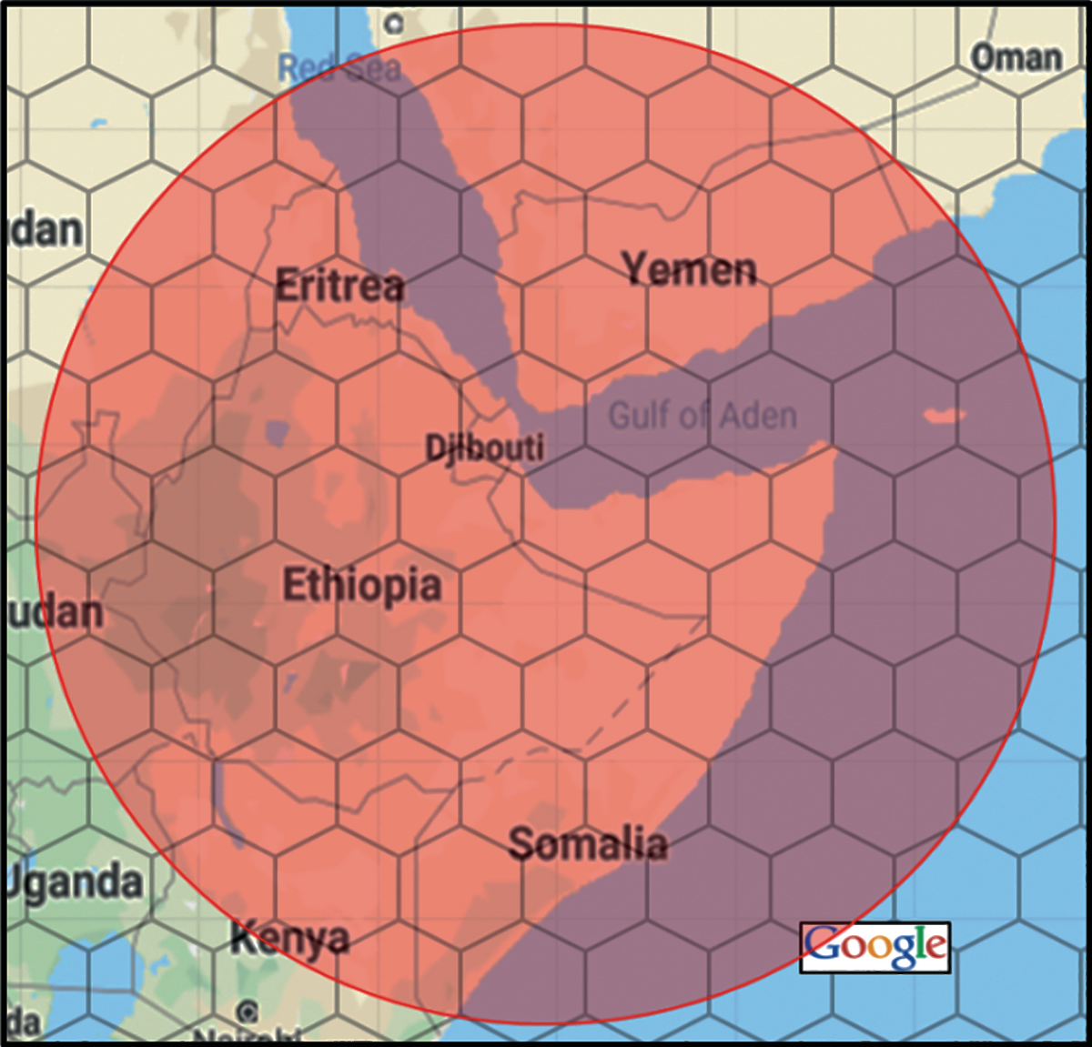 Figure 2. Comparison of beam sizes for different satellites.
The pilot enables estimation of the time, frequency, and phase of the received samples. The same pilot can be used as the basis for reliable detection of the burst if it contains enough energy. The point at which the waveform will have sufficient energy is when the burst’s length exceeds ~100 information bits. Hence a burst length of 128 bits is used. This length is well matched to transmission of information such as terminal locations (~40 bits) and meter readings (several 10’s of bits).
These key foundations underlie a system that provides a variety of connectivity modes. All modes (other than broadcast) include acknowledgement.
• Scheduled Transmissions of data from the terminals, e.g., meter readings, and location reports.
• Terminal-originated (alarm) connectivity, including
◊ Rapid Alarms: where terminal status is communicated to the network within 1-2 seconds.
◊ Baseline Alarms: where a terminal establishes connectivity and information can be exchanged in both directions using multiple bursts.
• Network-originated (paged) connectivity, including
◊ Rapid Page: network information is communicated to a terminal also within ~1-2 seconds.
◊ Baseline Page: the network establishes connectivity — information can be exchanged in both directions using multiple bursts.
• Broadcast from the network to terminals within a beam, e.g., transmission of a news feed or weather information.
Scheduled Transmissions illustrate efficient communication of small quantities of data. Messages can be sent from terminals with single burst transmissions, zero overhead related to terminal identity, and with robust acknowledgements from the satellite that correspond approximately to transmission of a single bit every 100 messages. The resulting satellite power savings enable operation of around a billion terminals per satellite. The concept of applying GEO satellites to IoT-type applications has generated significant interest among the MSS satellite operators. For example, Inmarsat and eSAT have tested the air interface over real satellite links, confirming both the robustness of the approach and compliance to the anticipated link performance.
In summary, GEO MSS satellites offer a platform for ubiquitous IoT connectivity with:
• Terminals with lower cost, size, weight, and power than both all existing services, and all envisaged LEO systems
• Capacity that greatly exceeds that of LEO systems
• Capital expenditure that is much lower than LEO systems
• Applicability to a broad range of applications at costs below $1/month
References
1Example small LEO system websites: https://www.astrocast.com/, https://hiber.global/, https://www.fleet.space/, https://helioswire.com/, http://lacuna.space/, https://myriota.com, https://www.swarm.space/, https://www.kineis.com/en/
2The 2018 summer of satellite IoT – 18 startups, over 1,600 satellites, July 4, 2018, https://www.spaceitbridge.com/the-2018-summer-of-satellite-iot-18-startups-over-1600-satellites.htm
3eSAT Global NSF Grant, https://seedfund.nsf.gov/awardees/phase-1/details/?company=esat-global-inc

4Code Performance as a Function of Block Size, S. Dolinar, D. Divsalar, and F. Pollara, TMO Progress Report 42-13, May 15, 1998, https://ipnpr.jpl.nasa.gov/progress_report/42-133/133K.pdf
Mike Parr is the CTO at eSAT Global. He has been a system engineer in the satellite industry for more than 30 years — most of that experience has been in the mobile satellite area. His email is michael.parr@esatglobal.com