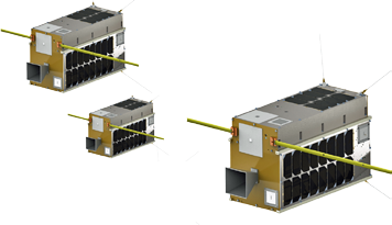
The world is entering a renaissance age for the smallsat.

Technological advancements of all types, including those observed by Moore’s Law, coupled with greater speed and agility in smallsat manufacturing, have helped to reduce barriers to entry in space and allowed the space industry to increase processing power at a fraction of the cost. This increased power allows new access to untapped sources of data about the radio frequency (RF) portion of electromagnetic spectrum—and presents opportunities for improving the quality of life here on Earth.
Much of today’s global economy uses the RF spectrum, from consumer electronics such as cell phones to communications networks that first responders rely on for emergency situations. However, there is currently no cost-effective way to monitor, locate, and visualize the use of this important, yet finite, resource whose channels are congested, competitive, and contested. Understanding and visualizing RF spectrum usage is critical to making decisions about future spectrum allocations and use. To develop the Big Data analytic capabilities needed to dynamically manage spectrum, the first step must be to efficiently collect the RF source data.
The need for a system that collects and analyzes information associated with RF spectrum utilization helped to inspire the formation of HawkEye 360 in September of 2015. Thanks to the recent evolution of smallsats, the company has been able to develop a new, space-based global intelligence network that will help to make visible what was once invisible about the RF spectrum and unlock the true value of Big Data.
HawkEye 360 is developing a Pathfinder Cluster mission of three smallsats that is scheduled to launch to Low Earth Orbit (LEO) by the end of 2017. Within two years of that launch, the company plans to have an operational constellation deployment of another six, three-ship clusters.
Each of the smallsats will have receive-only software-defined radios running proprietary software, allowing us to detect, characterize, and geolocate a wide range of RF emitters. HawkEye 360’s ground-based analytics platform will then fuse open-source data, commercial satellite imagery, digital terrain elevation data, and RF data to generate tailored analytics reports for customers.
The HawkEye 360’s satellite constellation is being designed to be able to detect a wide range of signals with a high degree of precision and minimal latency. Once operational, it will be able to provide visualization and tracking of a variety of activities on Earth, support to RF signal geolocation efforts, and add resiliency to today’s space infrastructure.
Making The HawkEye 360 Possible
Smallsat Propulsion: A Key Enabler
One of the challenges facing smallsat designers is developing a propulsion system that is on par with those in operation on larger spacecraft. For HawkEye 360, finding the appropriate propulsion solution was just as important as the microelectronics going into the software-defined radios and was a key decision point for selecting Deep Space Industries (DSI) and their partner, Space Flight Laboratories, as the prime spacecraft supplier.
The DSI Comet-1™ electrothermal micropropulsion system provides the necessary thrust and stored delta-v to support HawkEye 360’s station-keeping requirements throughout the planned, three-year smallsat design lifespan with enough of a margin to surpass that estimate as well as to de-orbit the satellites, if necessary, for debris mitigation compliance. The use of water as the propellant in the Comet-1™ also greatly simplifies the satellites’ pre-launch ground processing and launch procedures.
Open Standard Software-Defined Radios
Another important enabling technology was advancement in the open-standard software-defined radios (SDR). Using GNU Radio as the foundation for the RF receiver payload, HawkEye 360 is combining proprietary code with advanced Field Programmable Gate Arrays (FPGA), allowing for signal detection, characterization, and geolocation capabilities updates throughout each spacecraft’s three-year design lifetime.
Big Data: A Revolution In Situational Awareness
As interesting as the spacecraft are, the real value of the HawkEye 360 system will be in distilling RF spectrum utilization data into actionable information that customers can use to solve hard problems. Over time, the expectation is that the satellites will become increasingly autonomous through the development of robust machine learning capabilities. This will, for example, allow the system to predict future behavior and trigger commercial satellite imagery or receive similar tip-off information from the imaging systems. Ultimately, an integrated machine-to-machine (M2M) system that facilitates new levels of situational awareness in the transportation, maritime and wireless communications (terrestrial and satellite) markets is expected.
A Different Way To View The World
Thanks to the growth and availability of remote sensing systems and their data, the geospatial industry is thriving and evolving beyond only images of objects. Activity Based Information (ABI), looking at why something is happening in addition to where it’s happening, is driving new methodologies for observing activity on Earth. Combining various data sources allows the geospatial analyst to infer additional insights beyond just the static snapshot of the scene.
HawkEye 360’s RF data will take ABI a step further by creating contextualized activity-based information (CABI). For example, if there is a commercial satellite image of various ships in a specific maritime economic exclusion zone (EEZ), several questions would come to mind:
1. Who are the ships?
2. What are they doing?
3. Are they supposed to be there?

The static image, depending on resolution and cloud cover, may allow for answers to some of these questions—HawkEye 360’s data analytics are being developed to provide those answers and more.
The company’s Maritime Domain Awareness line of analytic products is designed to determine a ship’s identity and self-reported location from the Automatic Identification System (AIS) broadcast. This ability is differentiated from other commercial sources of AIS data by also providing an independent geolocation of the AIS broadcast itself to verify that the ship is at the reported location. This is important as a nefarious actor could easily spoof that
reported location.
What occurs if the AIS-identified ship is not on the EEZ owner’s authorized list and the ship’s captain turns off AIS believing such would enable avoidance of detection? At HawkEye 360, the planned system will be well positioned to address this real scenario.
In addition to AIS, the system has been designed to collect and geolocate other sources of RF data, such as from the ship’s navigation radar or satellite communications. This information, can be used in combination with AIS if available, to dynamically observe the ship’s heading, speed, and course, thereby allowing for an inference as to the nature of a vessel’s activity and to provide the missing context of that original satellite image.
Tip-off messaging will also be supplied to commercial space imaging partners in order for them to provide a current image of a suspect ship. HawkEye 360’s watch center will take the updated image, combine that image with the RF track data, and produce data analysis that the customer could then use to pursue legal recourse against the trespasser.
Assisting the fishing, shipping and other transportation-related industries with geolocation services is just one example of potential applications for the HawkEye 360 system. Others include:
Emergency Response/Search and Rescue: Minutes matter in an emergency. With the incorporated data analytics, Search and Rescue teams will be able to better pinpoint people in distress. HawkEye 360’s technology will be able to collect information from emergency locator beacons and independently locate those beacons to account for a damaged GPS receiver or locations with poor GPS reception. The HawkEye 360 team will work with First Responders and emergency government agencies to quickly gather critical intelligence and offer multiple services to support Emergency Response and Search and Rescue efforts.
In the chaotic aftermath of a natural disaster such as a hurricane landfall, one of the necessary tasks is to establish reliable lines of communications between First Responders, disaster response agencies, rescue organizations, and survivors. HawkEye 360’s RF mapping design is being developed to quickly identify what wireless communications technology (e.g. radio towers) are still working and what the available communication mechanisms are.
Spectrum sustainability and security: Today’s global communications systems are plagued by a variety of interference, both intentional and unintentional. The ability to respond quickly and efficiently to such interference is often critical to avoid a negative impact to operations and human lives. Existing methodologies to determine the location and source of the interference can be expensive to use and generally take a long time to produce precise location data on the interference source. HawkEye 360 seeks to improve this process with precision geolocation algorithms. This capability has the potential to increase the global resiliency and operational efficiency of communications systems with the development of a broadband monitoring satellite with a high revisit rate and low latency to combat growing interference issues.
Spectrum management: New concepts, such as shared spectrum usage, can change quickly based on demand and availability. These types of systems require special tools and data to efficiently operate in a dynamic spectrum environment. Emerging tools for managing these dynamics typically utilize ground-based RF sensing systems which have very limited range and high operating costs. They must also be physically present in the location in question. HawkEye 360’s approach essentially takes that limited ground-sensing system to orbit. The satellites are designed to collect RF signal information over an area that is hundreds of miles in diameter. This will allow services that offer cost effective, rapid spectrum usage data.
Because the satellites can be updated on a regular basis as technologies change via their SDRs, HawkEye 360 will be able to efficiently and accurately collect the necessary information to visualize RF spectrum usage in near real-time. This data can be used to create one of the first-ever global spectrum inventory and mapping processes that will have the ability to provide accurate and cost-effective utilization data to government regulators. This tool could help accelerate spectrum knowledge and enable broader and more rapid adoption of spectrum sharing policies.
The demand for access to additional RF spectrum will continue to grow and HawkEye 360 plans to be there to support that growth with capabilities that have the potential to redefine how governments and industries view and use the RF spectrum, with a cost-effective approach to precisely mapping spectrum usage. That knowledge is a key enabler and could bring about a renaissance in spectrum allocation and use.
A Bright Future
At HawkEye 360, the future is exciting. The firm thrives on solving big problems in collaboration with industry and government partners. With successful airborne demonstrations this year to the planned Pathfinder Cluster launch next year, HawkEye 360 is moving forward at a rapid pace in an effort to bring commercial RF sensing from space to market and to help change the way we all look at the world.
www.he360.com

As Vice President of Sales, Russ develops and manages relationships with commercial, government, and international clientele. He is a retired US Air Force Lieutenant Colonel with more than 25 years of space, satellite, and aeronautics experience. During his military career, he led teams on world-wide deployments, integrating space-based solutions into tactical environments; routinely briefed high-level military and civil officials on complex national security issues; and managed high-budget aerospace technology programs. Since his retirement from active duty in 2011, Russ has served in key business development positions with SAIC and Northrop Grumman, and owns his own consulting firm focused on aerospace technology market analysis. An accomplished competitive sailboat racer, he also enjoys songwriting and playing his guitar in church.
HawkEye 360’s Vice President Russ Matijevich's Insights...
HawkEye 360 is developing a space-based global intelligence network that will use radio frequency (RF) technology to help monitor transportation across air, land and sea and assist with emergencies. The company’s envisioned constellation of smallsats in LEO will collect information on specific radio signals worldwide to provide high-precision radio frequency mapping and analytics that can be customized to clients’ needs.
What applications do you see as most valuable to HawkEye 360’s business?
Matijevich: Initially, our Maritime Domain Awareness application will be of primary interest because it directly addresses many of the hard problems facing the maritime industry, such as illegal fishing. But in the long term, we expect the data analytics that we’ll distill down from this massive amount of RF-related data we’ll be collecting will be helpful to a variety of industries — from wireless carriers to emergency responders and transportation and logistics providers. Ultimately, we believe that our system will help change the way folks look at the world.
You’ve alluded to parallels about what HE360 is trying to achieve with advances in the satellite imagery market. Can you elaborate?
Matijevich: When commercial satellite imagery first became available, most folks looked at it as nothing more than an unclassified version of Government-produced imagery. And in the early days, commercial satellite imagery was mostly used in unclassified settings, filling a basic need for images. Since that time, we’ve seen a revolution in the applicability and usability of commercial satellite imagery bolstered by the widespread use of geospatial information. In the RF signal collection world, I think we’ll see a similar evolution. We’ll begin by performing traditional observation tasks of “this signal was active at this time from this latitude and longitude,” but eventually we’ll see advances in data analytics and machine-to-machine automation.
Please discuss how a service like HE360’s can help with recent policy discussions at the FCC about new ways to dynamically share spectrum.
Matijevich: RF spectrum is a finite resource that is becoming increasingly congested, competitive and contested. As the FCC and other regulatory agencies work to manage it, they’re lacking a key piece of information: How is the spectrum truly being used? They have databases of license holders, but they don’t have a cost-effective way to verify that the license holders are using the spectrum in accordance with their license. And they don’t have a cost-effective way to independently determine what spectrum is available in any given area. One of our goals at HawkEye 360 is to provide them with that cost-effective mechanism to develop a national spectrum inventory.
You mentioned how smallsat speed and agility are changing the face of commercial space. How does HawkEye 360 plan on harnessing those qualities?
Matijevich: Our pathfinder mission is on a schedule to go from on-contract to ready to launch in 12 months. The goal is to have our follow-on missions go even faster, combining speed with the agility of updating our payload, either through hardware for a new satellite or via our on-board software-defined radios. Let’s think about it in terms of cost savings while still being able to perform a mission. For a full-size government-sponsored satellite, those programs tend to take upwards of 10 years to get on orbit and can cost close to $1 billion over that decade. By comparison, we expect to be ready to launch in 12 months with cost savings by an order of magnitude of 100x.
Why did you select DSI for your satellite manufacturing?
Matijevich: DSI initially impressed us with the propulsion systems they’ve developed. We anticipate needing a good amount of on-demand, impulsive delta V during our three-year design life, and the DSI system really stood out. As we got to know the teams at DSI and Space Flight Labs, we realized that we all shared a vision of using smallsats to conquer hard problems in space — and the relationship just clicked. We’re working well together and excited about what the future will bring.


