
Radio frequency interference (RFI) has long been an issue that has to be managed by the satellite communications industry. This is an issue that will continue to grow as the demand for satellite bandwidth increases, driven by technology advances that, in turn, create new bandwidth-hungry applications. The issue was certainly of concern in 2014 and will definitely present a crucial challenge in 2015.
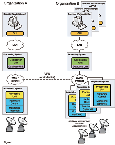
By separating the main system capability from the data acquisition sites, the data acquisition sites can actually be shared by multiple entities.
Operators and industry groups report that signal interference significantly impacts profit margins, quality of service and operational efficiency. As our Year In Review offering, we’d like to take a closer look at satellite interference and how such can be remediated.
The first step toward neutralizing the disruptive effects of satellite interference is the rapid detection of that interference via effective monitoring. Today, there are numerous carrier signal monitoring systems and services that can be of significant help in this regard. The next step is to geolocate the interfering signal; however, satellite signal geolocation systems have often been considered expensive, difficult to use, and often thought of as a scientific tool, as opposed to an operational one. Because of this perception (and in the past, some reality), a satellite signal geolocation system was often the solution of last resort.
Recent advancements in geolocation systems have changed this situation. Changes in architecture have resulted in global systems that are much more affordable than in the past, and increases in usability have enabled systems that are much easier to use.
Greater Affordability=Greater Accessibility
By taking a modular approach to the architecture, the logic and control components are separated from the acquisition capability. This allows for deployment of logic and control components in a central operations center, thereby minimizing hardware and software requirements at data acquisition sites—this makes multiple site deployments more affordable.
In addition to less expensive deployment costs for multiple data acquisition sites, usage at each site can be maximized. By separating the main system capability from the data acquisition sites, the data acquisition sites can actually be shared by multiple entities. When two organizations share a deployment, they reduce costs through the deployment of a single geolocation acquisition system.
Additionally, there is a potentially significant saving on antennas, which are often more costly than the geolocation system. These shared acquisition systems contain only non-proprietary data, ensuring operations from both organizations are completely separate.
A typical scenario might be where organization (A) has a geolocation system and one or more acquisition sites but needs temporary acquisition capability at another site. If organization (B) has acquisition capability at that site, and has the willingness and capacity to share, organization (A) can access organization (B) site via establishment of a WAN connection and then transmit the data to its geolocation system. (See Figure 1 above.)
This new modular architecture is designed for hardware acquisition sharing, making data sampling interleaving possible. This feature also enables sharing of the acquisition hardware on a sample interval timeframe and it is handled automatically. Whether the acquisition site is shared by multiple operators within a single organization, or by multiple organizations, the hardware can be used more efficiently.
Today’s geolocation systems are generally integrated with carrier signal monitoring (CSM) capability. Integration with CSM capability, at a minimum, saves the cost of hardware common to both capabilities.
Ease-Of-Use
Modern geolocation systems have new features and capabilities that are designed to save operator effort and cost. Features such as scenario templates, higher levels of automation, improved reporting capability and integrated operator notebooks enable geolocation to be performed by more operators with less experience. This not only improves the efficiency and return from the system but can represent a significant financial savings to the organization.
Geolocation scenario templates are designed to allow a Level 1 geolocation operator to perform the scenario investigation, determine the secondary satellite, best reference signals and other settings to use for a given scenario. All of this information can be saved in a template. Later, when an operator has an interfering signal to geolocate, s/he simply provides the satellite, transponder and frequency of the interference to the template in which all other parameters were previously loaded. The operator can then start taking geolocation samples within seconds.
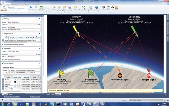
This “Diagram View” of the satID user interface shows the current measurement scenario. This includes the signals being measured, the satellites being used, and the ground station(s) used to receive those signals
Improved operator documentation functions within the geolocation product also improve ease-of-use and efficiency. When novice operators perform a geolocation, they can more easily take notes and save screenshots from the process within the geolocation session. This has some benefits: the information is saved with the session so it can be recalled, instead of in a paper notebook or separate documentation. As the information and notes are within the session, they can be included in a geolocation report at the completion of the campaign. Operators can generate a report of the geolocation results and have their work reviewed by a geolocation expert. This helps to distribute the geolocation responsibilities among more people within the organization, increasing the effectiveness of the system.
Many geolocation systems have increased the amount of automation within the system and geolocation process. Recent advances in automation include sampling and processing, such as ephemeris correction and result averaging. By automating more of the process, operators are less likely to make mistakes and the overall geolocation process is performed more quickly. A geolocation of an interferer can be started as soon as possible following the identification of the interference. When the tools are easy and efficient to use, operators will take advantage of them, and the system becomes more efficient.
No Longer A Solution Of Last Resort
Developments such as these in geolocation system affordability and ease of use have made satellite signal geolocation systems more accessible, enabling more operators to better manage increasingly congested bandwidth. Geolocation systems are no longer considered the tool of last resort.

Dr. Rob Rideout is the Director of Strategic Planning for SAT Corporation, a subsidiary of U.S.-based Kratos Defense and Security Solutions and a leading supplier of innovative satellite monitoring and interference geolocation systems for the space and aerospace industry.
Rob spent 12 years working in the U.K. defence sector before moving to SAT Corporation and to-date has dedicated the last 16 years of his career investigating and developing technologies to combat the ever increasing and disruptive effects of interference to satellite communications. Rob has promoted the benefits of interference detection and mitigation techniques around the world to military, government and commercial satellite operators at international forums, and has regularly been called upon to advise government departments and their key advisors, and regulators.
Rob obtained a Ph.D. from the University of Birmingham (UK) in the field of high energy astrophysics in 1995.
ID’ing Interference
Powerful, flexible, and modular, satID from SAT Corporation, a Kratos Company, is an easy-to-use package for locating and identifying sources of RF interference. Now, with its unique antenna sharing capability, operators can reduce capex by distributing antenna capacity with another party who has extra capacity and the willingness to share that capacity.
New, innovative scenario templates created by higher level operators can be used by lower level operators to ensure the accuracy of results. In most cases, scenarios can be created and begin receiving pinpointed geolocation results displayed on a map within minutes.
satID employs a map-driven user interface to giving operators the ability to perform geolocation scenarios more efficiently and effectively. Geolocation operations can be conducted directly from the map, removing the reliance on less intuitive menu selections for geolocation scenarios.
The satID infosite is located at http://www.sat.com/products/satid