
The space around Earth is filled with debris from hardware leftover from thousands of launches since mankind first ventured into space in 1957. Estimates vary, but more than 21,000 debris fragments are currently tracked, and there are an estimated half million to one million fragments between one and ten centimeters in size.
At a recent AIAA ASCEND Space Traffic Coordination and Management (STCM) special session, Dan Oltrogge of COMSPOC Corporation presented results from an STCM demonstration with participants SES and the SDA. This comprehensive demonstration clearly showed the dramatic space flight safety improvements possible by applying advanced data fusion and analytical techniques across diverse data from multiple data sources (including government, spacecraft operators, and commercial SSA service providers).

As I mentioned in that session, I noted that achieving effective SSA and STCM will require satellite operators to contribute as a strict minimum up-to-date ephemeris and planned maneuver information. This need was recognized ten years ago by the major Geosynchronous Earth Orbit (GEO) operators, who also realized that STCM should not be geographically limited as any accidents in any one part of the GEO belt would quickly affect the entire global space environment.
This recognition led to the formation of an international organization to handle SSA on a global level, the Space Data Association. The operational arm of the SDA, the Space Data Center (SDC), has been operated by Analytical Graphics Inc. (AGI) and COMSPOC Corporation for more than a decade.
How do we ensure the correct SSA processes are in place in the current climate? Currently, there are two key elements of the SDC that significantly improve SSA:
The SDC uses a Data Lake construct that “meets the operators where they are,” normalizing each operator’s unique raw data formats to allow multi-source data to be combined to enhance safety of flight analyses. The SDC is closely monitored for data quality by experts at Analytical Graphics Inc and COMSPOC Corporation. Over the years, the team has revealed many discrepancies in SSA and operator-owned space data products.
Since inception, the SDC has revolutionized SSA by using these processes to ensure that SSA information is as good as possible. But even that is no longer sufficient for effective STCM due to the sheer volume of spacecraft and debris in orbit today, coupled with the continuing rapid continued growth in operational spacecraft in this New Space era.
Current Situation
The space environment is becoming more and more crowded and complex. During the ASCEND session, Mark Daley from the US Department of Commerce commented, “The space environment continues to grow more complex and diverse as activities accelerate and new space missions emerge. We have seen prominent near-misses, and the continuing fragmentation of historical debris creates new hazards. Space debris could potentially reverse some of the commercial efficiencies that are fueling growth.”
As further evidence of increased collision risk, COMSPOC and SDA drew upon the CelesTrak “Satellite Orbital Conjunction Reports Assessing Threatening Encounters in Space (SOCRATES)1” and SDC conjunction data archives going back to 2005 and 2017, respectively.
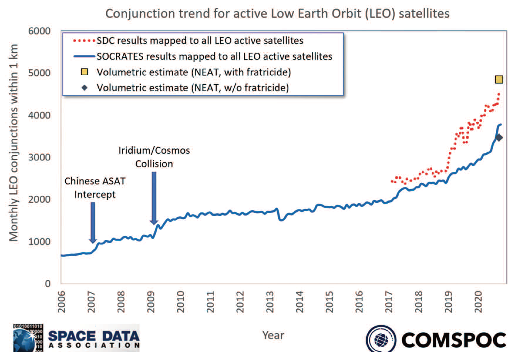 Click to enlarge.
The results were sobering. Dan Oltrogge of COMSPOC Corporation observed that, “Prior to 2017, the rate of conjunctions experienced by Low Earth Orbit (LEO) spacecraft was largely in a quiescent period with little change. But since 2017, this rate (and accompanying collision risk) has increased dramatically, as much as double the rate observed just three years ago. Talking to space agencies from around the world, they are experiencing a lot more conjunctions with the new large constellations and the growing space debris population.”
What More do we Need for Effective SSA?
Over recent years, we have been championing the need for more, and better quality, data, as well as better tools to help us greatly improve collision avoidance measures. The challenge has always been getting financial backing to improve systems to track that data without an immediate return on investment or definitive threat. However, more and better data and the tools to process them will be vital to ensuring effective safety of flight. We believe that operators should be looking to contribute additional raw measurements such as:
• Standard tone ranging and azimuth / elevation measurements, transponder ranging
• On-board GPS measurements
• More advanced measurements like PaCoRa passive RF data, which relies on time difference of arrival of the satellite payload signal at different ground stations
• Optical or radar observations, if available
These raw measurements support effective data quality control and comprehensive data fusion to identify potential measurement biases and yield the best predictive information needed to assess collision risk and avoid confirmation bias.
If these are also coupled with satellite dimensions and attitude information, it would enable much more accurate probability of collision assessments.
The Proof is in the Pudding
Together with AGI, COMSPOC, the SDA and the 18th Space Control Squadron, we set out to prove how comprehensive data sharing, data fusion, and advanced analytics can lead to orbit solutions that are sufficiently accurate to support STCM and long-term space sustainability. The observed steep increase in conjunction rates helped motivate us to jointly conduct the STCM demonstration.
The idea was to demonstrate what could be achieved by bringing all the data together in a comprehensive way. The demonstration itself fused data from twelve different companies.
Dan explained, “We picked 17 spacecraft. These were handpicked to try and get some orbit regime diversity. We wanted some satellites in LEO, some in MEO, and some satellites in GEO. We also wanted some that had GPS and Wide-Area Augmentation System (WAAS) data so that very accurate reference orbits could be formed, as well as to include some of the GEO spacecraft clusters that are out there.”
This was, of course, just a small sample of today’s active spacecraft population, but goes some way to demonstrating STCM possibilities and processes.
The Analysis Covered Five Categories of SSA Information:
1.Two Line Elements sets (TLEs) formed from optical and radar observations. These do not include planned maneuvers.
2. SP data, similar to TLEs.
3. Operator data, which includes active ranging and planned maneuvers, and in some instances passive RF, GPS observations.
4. GPS navigation solutions (NavSol).
5. Fused solutions, which incorporated optical, radar, passive RF, active ranging, and planned maneuvers.
Results showed that for this limited set of spacecraft, the fused orbit solutions were typically two times more accurate in LEO than non-fused solutions, and ten times more accurate in GEO. Importantly, the fused solutions were often able to meet collision probability-based accuracy requirements, while the non-fused solutions typically were not.
The Future of SSA

What this demonstration showed above all else is that the more data you can input, the more accurate your predictions and warnings become. This in turn yields more actionable alerts to spacecraft operators that can guide them in the best course of action. As space continues to get more and more crowded, it is imperative that we improve the amount of data and the data fusion and analysis tools that process it. Doing so will require some level of investment, either from the commercial operators or, ideally, from government organizations. But the result will be a safer environment for all.
www.space-data.org
Author Pascal Wauthier is the SDA Executive Director. He joined SES in 1990. His role in the Technology organization is to lead SES Space Operations. This function is responsible for safely operating the SES GEO and MEO (O3b) satellites.