
Maritime Domain Awareness (MDA) is critical to the safety and security of the U.S. and allied nations, having a profound impact on environmental and economic interests. Advanced intelligence capabilities at sea empower navies and coast guards with vital insights to effectively combat illegal, unreported, and unregulated (IUU) fishing, smuggling, sanctions evasion, and other illicit activities. As the number of vessels navigating the waters globally continues to rise, our reliance on tools and technologies to gain insights into vessel whereabouts and maritime activities has significantly increased.

HawkEye 360 has developed an exceptional suite of Maritime Analytics based on radio frequency (RF) technology, offering unparalleled insights into extensive data sets. With our RF satellites, HawkEye 360 provides a broad field of view that spans millions of square kilometers, enabling comprehensive monitoring of vast areas. This expansive coverage, combined with a consistent area monitoring schedule, establishes a robust baseline of activity and facilitates the detection of anomalous behaviors for in-depth investigation.
RF signal geolocations offer a streamlined analysis process, distinguishing them from other satellite-based earth observation modalities and facilitating the extraction of valuable insights from the data. RF data in the maritime domain provides a broad and comprehensive snapshot of all activities in a given region. This large-scale survey offers valuable insights into vessel movements, patterns, and anomalies, enhancing situational awareness and providing a holistic understanding of maritime activities.
Locating ship traffic from their RF emissions offers a unique and powerful marine data set to fill the gaps in traditional methods of vessel tracking. The HawkEye 360 constellation independently geolocates a diverse set of signals emitted by ships, such as marine radars, push-to-talk radios, satellite phones, emergency beacons, and automatic identification systems (AIS).
RF intelligence is a non-negotiable foundation of defense missions. It expands our reach into remote areas and across territorial borders. It penetrates any darkness and weather obstruction. It uncovers adversary installations and activities.
HawkEye 360’s space-based RF delivers superior global situational awareness. In this heightened global security environment, it is important for analysts to quickly parse, analyze, and deliver intelligence in support of each mission. Leading with this RF intelligence offers analysts a quicker grasp of critical events, early warning, which drives tip-and-cue efforts, delivering a unique advantage to counter threats with greater precision and speed.
Filling The Gaps Of AIS Intelligence
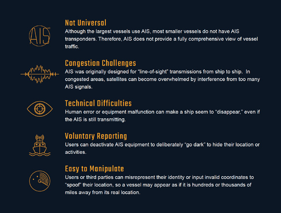
AIS data has proven very useful in monitoring ship traffic, but AIS alone is not a comprehensive maritime domain awareness tool. AIS receivers along the coastline receive AIS transmissions, mapping vessel locations as far as 20 to 50 miles from the coast. Satellites gather AIS from vessels in the deep ocean, helping to fill the rest of the map. But AIS relies on voluntary and accurate reporting from vessels, making it possible for individuals to circumvent the system and operate in secret. Vessels engaged in sanctions evasion, smuggling, piracy, illegal fishing, and human trafficking often deactivate AIS transponders to become “dark ships,” or they self-report false positions, otherwise known as “spoofing.”
While AIS is a valuable data source, its capabilities are inherently limited due to the nature of the technology and reporting methodology. AIS faces the following limitations:
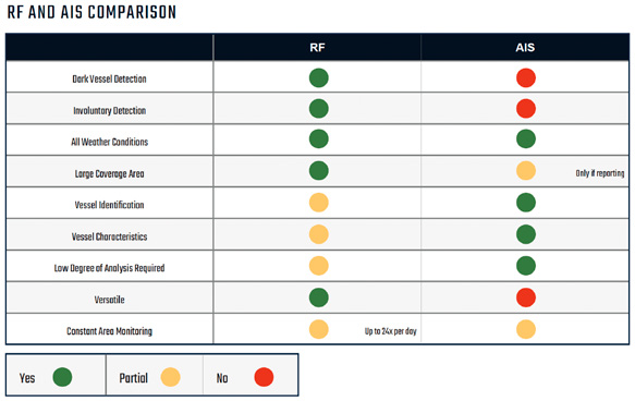
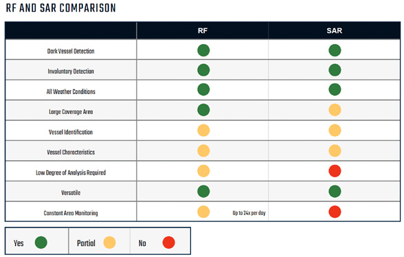
AIS data alone can be an incomplete and unreliable source for monitoring maritime activity. For AIS data to be collected by satellite and terrestrial sensors, vessels must voluntarily report their position and identification information via their AIS system. The largest gap in AIS data comes from the intentional termination of this transmission by vessels. In contrast, HawkEye 360 relies upon RF signal data, captured from a diverse set of sources including marine radars, satellite phones, and push-to-talk radios, to detect and monitor vessels at sea. Because vessels routinely radiate to navigate and communicate, collection of those essential operations creates involuntary data that counters most efforts to “hide” at sea.
RF data is valuable in maritime applications when a vessel turns off its AIS transponder or falsifies (“spoofs”) its AIS signal to try to hide its true location. HawkEye 360’s constellation of satellites collects and analyzes a wide range of RF signals to fill the gaps in AIS dark ship detection. We ‘connect the dots’ by fusing our data with that of global AIS to locate vessels in which the AIS signal is dark and others where RF signals can be correlated to a vessel.
Imagery Intelligence Made Stronger With RF
Imagery intelligence gathered using either satellites or airplanes provides information about the location and physical characteristics of an environment. Imagery is a widely used source of information concerning key terrain features, installations, and infrastructure used to build detailed intelligence reports.
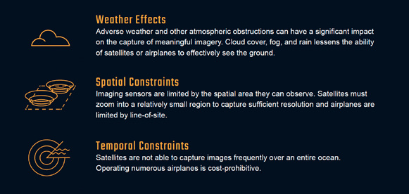
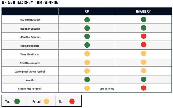
Analysts engaged in maritime domain awareness rely on imagery for ship detection, identification, and classification, as well as to corroborate maritime activity detected through other modalities. But imagery intelligence captures a narrow field, is usually just a ‘snapshot’ in one specific time and place, and is costly to deploy. Imagery alone has several shortcomings:
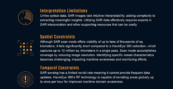
HawkEye 360’s RF technology provides extensive coverage, spanning millions of square kilometers with up to 24 daily data collections. This global RF data acquisition enables diverse applications, particularly in busy maritime areas. In contrast, SAR imaging has a smaller footprint, requiring more collections to achieve comparable coverage to RF satellites. Implementing an RF-driven workflow enhances efficiency and accuracy in SAR operations.
By combining SAR and RF data, we leverage the strengths of both modalities to enhance maritime monitoring and intelligence. SAR’s detailed radar imaging complements RF’s wide coverage, enabling precise vessel detection and classification. This collaboration offers a more comprehensive view of maritime activities, enhancing situational awareness.
While SAR requires more collections to match the coverage of a single pass by RF satellites, the fusion of SAR and RF data provides a complete understanding of maritime environments. This integration optimizes intelligence gathering, empowering users with actionable insights for maritime security and operational decision-making.
Together, SAR and RF technology create a powerful synergy, leveraging RF’s coverage efficiency and SAR’s detailed imaging capabilities. This collaborative approach delivers enhanced awareness of the maritime domain, enabling effective responses to challenges and emerging threats.
Multi-Int Data Fusion
Decision-makers mitigate risk by leveraging assessments built on multi- intelligence (Multi-INT) data fusion. Fused intelligence establishes trust and confidence between analysts and decision-makers, providing crucial context for high-risk scenarios with limited resources and time constraints. Analysts rely on diverse intelligence sources daily to construct assessments and earn this trust. RF geolocation data plays a significant role in uncovering hidden mission insights, optimizing resource allocation, and saving valuable time and resources. Recognizing the strengths of each modality, RF emerges as a vital initial insight that empowers analysts to further explore the situation using additional intelligence sources.
For example, an intelligence analyst uses RF signal data as a starting point to detect a suspicious vessel involved in potential illegal fishing activities. Comparing the RF signals with AIS data reveals that the vessel is not transmitting AIS information, potentially indicating an intentional attempt to avoid detection. By incorporating electro-optical (EO) or SAR imagery, the analyst not only confirms the presence of the vessel but also strengthens the theory of a dark vessel engaged in illicit activities.
This Multi-INT fusion provides a holistic and robust approach to intelligence gathering and target identification in the maritime domain.
Conclusion
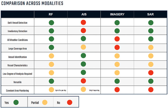
It’s evident that AIS, Imagery Intelligence, and SAR each offer invaluable contributions to enhancing maritime domain awareness, despite their individual limitations. They each bring a unique perspective, adding layers to our understanding of the maritime landscape.
Yet, HawkEye 360’s RF-based Maritime Analytics takes this understanding a step further. It not only fills the gaps left by traditional methods, but it also provides a significantly broader coverage and data collection frequency. This offers an unmatched ability to survey maritime activities on a global scale.
When these technologies come together in a Multi-INT approach, their combined power truly shines. This integration forms a collaborative, all- encompassing intelligence-gathering system that greatly boosts maritime security operations. This unified approach paints a holistic picture of the maritime domain, providing analysts with a robust and comprehensive tool for threat detection and assessment. With the collective strengths of these systems at our disposal, we can navigate the maritime landscape with greater confidence, security, and efficiency.
The success of our maritime security efforts is not solely reliant on advanced technology, but also on our ability to work together. HawkEye360 data and analysis unlocks insights that can be shared more quickly and easily than other information. That advantage shortens the timeline from assessment to decision when working with partners, which in turn builds trust across those relationships. By fostering a positive and collaborative atmosphere amongst all stakeholders, we can maximize the potential of these technologies, elevating Maritime Domain Awareness to new heights, and ensuring the safety and security of our seas for future generations.
www.he360.com

Author Stacey Bruzzese has experience in regulated industries and NGOs and drives brand awareness and strategic growth. She harnesses her marketing, communications and publishing expertise to craft compelling content aligned with business goals. She is the Managing Editor for a technical journal and has exhibited leadership as the president of two, regional, commerce chambers. Stacey stays attuned to industry shifts and shares her insights on change management, particularly in the high-stakes defense and intelligence sectors.